Sold20201671 Montanus/Ogilby Map of Chile -- ChiliTitle/Content of Map: 1671 Montanus/Ogilby Map of Chile -- Chili Cartographer: Montanus/Ogilby Year/Place: 1671, London Size: 11.2 X 14.2 in. This is a very attractive map covering the coastal regionSee Sold Price
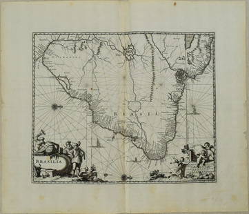
Sold20231671 Ogilby Map of Brazil -- BrasiliaTitle: 1671 Ogilby Map of Brazil -- Brasilia Cartographer: J Ogilby Year / Place: 1671, London Map Dimension (in.): 11.3 X 13.8 in. This is an excellent map of the eastern part of Brazil. There is anSee Sold Price
Sold20231671 Ogilby Map of Panama and Northern South America -- Terra Firma et Novum Regnum Granatense etDescriptionTitle: 1671 Ogilby Map of Panama and Northern South America -- Terra Firma et Novum Regnum Granatense et PopayanCartographer: J OgilbyYear / Place: 1671, LondonMap Dimension (in.): 11.3 X 1See Sold Price
Sold2017Nova Mexico folding map from American 1671 by OgilbyOgilby, John, 1600-1676, Montanus, Arnoldus, 1625?-1683, Nova Mexico from Novissima et Accuratissima Totius Americae Descriptio.11 x 21.25 inches, America: Being The Latest, And Most accurate DescriptSee Sold Price
Sold2023Colton's Argentine Republic, Chili, Uruguay & Paraguay. Argentina Chile 1863 mapTitle: Colton's Argentine Republic, Chili, Uruguay & Paraguay. Argentina Chile 1863 map Description: Colton's Argentine Republic, Chili, Uruguay & Paraguay' by Joseph Hutchins Colton (1863). Antique eSee Sold Price
Sold2023Colton's Argentine Republic, Chili, Uruguay & Paraguay. Argentina Chile 1869 mapTitle: Colton's Argentine Republic, Chili, Uruguay & Paraguay. Argentina Chile 1869 map Description: Colton's Argentine Republic, Chili, Uruguay & Paraguay' by Joseph Hutchins Colton (1869). Antique eSee Sold Price
Sold2018Montanus / Ogilby Novi BelgiMontanus, Petrus (1595-1638) & Ogilby, John (1600-1676). Nova Belgii Quod Nunc Novi Jork Vocatur... Engraved map with original color. J. Ogilby, 1671. 11 ½" x 14 ½" sheet. Centering on Long IslaSee Sold Price
Sold2017Montanus / Ogilby: Antique Map of Central America, 1671Map: Yucatan . . . et Guatimala Cartographer: Montanus / Ogilby Place & Date: Amsterdam / 1671 Size: 14 1/4" x 11 1/4" Condition: b&w; overall age toning and some spotting The detailed map of southeasSee Sold Price
Sold2019Montanus / Ogilby: Antique Map of Central America, 1671The detailed map of southeastern Mexico and Central America from Ogilby's English edition of Montanus' influential history of America. The map encompasses the Mexican heartland, the Yucatan peninsula,See Sold Price
Sold2019Map Chile Paraguay Uruguay 1860REPUBLIQUES DES PROVINCES UNIES (OU LA PALATA) DU CHILI DU PARAGUAY ET DE L’URUGUAY Beautiful coloured map of 1860 circa featuring Chile, Paraguay and Uruguay. Decorated frame. Date: 1860 circaSee Sold Price
Sold2019Map Chile La Plata part Bolivia 1840 HallCHILI LA PLATA AND PART OF BOLIVIA Beautiful big map of 1840 circa featuring Chile, La Plata and part of Bolivia Date: 1840 circa Author: S. Hall Technique: Copper etching Leaf Dimension: 44x29,5 cm (See Sold Price
Sold2018Bellin: Antique Map of South America, 1758TITLE OF THE MAP: 'Carte de l'Amerique Meridionale Pour l'Histoire Générale des Voyages in 8o.' A map of South America. Marked are Chili (Chile), Patagons (Patagonia), Buenos-Ayres 7 Tucuman (ArgentSee Sold Price
Sold20211857 Colton Map of Argentina, Paraguay, Uruguay andTitle: 1857 Colton Map of Argentina, Paraguay, Uruguay and Chile -- Argentine Republic, Chili, Uruguay & Paraguay Cartographer: J Colton Year / Place: 1855, New York Map Dimension (in.): 14.6 X 11.6 iSee Sold Price
Sold20201855 Colton Map of Argentina, Paraguay, Uruguay andTitle/Content of Map: 1855 Colton Map of Argentina, Paraguay, Uruguay and Chile -- Argentine Republic, Chili, Uruguay & Paraguay Cartographer: J Colton Year/Place: 1855, New York Size: 15.7 X 12.8 in.See Sold Price
Sold2023Ogilby / Montanus Map of the AmericasOGILBY, John (1600-1676) / MONTANUS, Arnoldus (c. 1625–1683). Insulae Americanae in Oceano Septentrionali cum Terris adiacentibus. Engraved map. London, 1671 (Second state). 16" x 20 1/2" sheet, 33"See Sold Price
Sold2017Hondius: Antique Map of Chile, 1635Title: Chili. Rare English edition of the Mercator-Hondius map of Chile Map maker: Henricus Hondius Place and Year: Amsterdam, c. 1635 Dimensions: 48. 3 x 36.8 cm (19 x 14.5 in) Technique: CopperplateSee Sold Price
Sold2024John Ogilby 1671 Antique "Nova Virginiae Tabula" Pencil Signed Hand Colored Virginia MapAntique 1671 hand-colored and pencil-signed "Nova Virginiae Tabula" map of Virginia and Chesapeake region. In good overall condition, with age-appropriate wear. Approx. image size 11 1/4" x 14". ApproSee Sold Price
Sold20241822 MAP of CHILI GEOGRAPHICAL STATISTICAL HISTORICAL antique 17.5x 22" CHILE1822 MAP of CHILE GEOGRAPHICAL STATISTICAL HISTORICAL # 51 from Carey & Lea’s Complete Historical, Chronological, and Geographical American Atlas. Overall size 17 1/2 by 21 3/4" Very good conditionSee Sold Price
Sold2015Map of Chile Patagonia Uruguay Paraguay. 1830.Victor Lavasseur. Map of Chile Patagonia Uruguay Paraguay. 1830.Print of hand colored steel engraving titled Chili Patagonie La Plata Uraguay Paraguay“.Author Victor Lavasseur.Engraved by unknown.FrSee Sold Price
Sold2021Tallis, John (Pub) 1852 Map. Chili and La Plata. ChileSteel Engraved Map with Original Outline Hand Color Published 1852-56 by John Tallis, London for "The Universal Pronouncing Dictionary" by Thomas Wright. Drawn & Engraved by John Rapkin. Centre fold aSee Sold Price
Sold2017Two Antique Maps Chili (sic) & Caribbean C. 16671) "Chili" (Chile), no publishers information, sight size 14.25" x 11.5", by Montanus A., C. 1670. (together with) 2) "Isles D'Amerique dites Caribes ov Cannibales et de Barlovento, by P. du Val d'abbSee Sold Price
Sold2020Map, John OgilbyJohn Ogilby (British, 1600-1676), "Nova Hispania Nova Galicia Guatimala (with part of Florida and Cuba)," 1671, hand-colored engraving, sight (image): 14"h x 11.5"w, overall (with mat/unframed): 17.5"See Sold Price
Sold2023Peru, Chili & La Plata Viceroyalty. Argentina Chile Bolivia. THOMSON 1830 mapTitle: "Peru, Chili & La Plata" Viceroyalty. Argentina Chile Bolivia. THOMSON 1830 map Description: Peru, Chili and La Plata' by Drawn & engraved for John Thomson's "New General Atlas" (1830). AntiqueSee Sold Price
Sold2017Thomson: Map of Peru Chili & La Plata, 1817TITLE/CONTENT OF MAP: 'Peru, Chili and La Plata' Viceroyalty. Argentina Chile Bolivia. This map is folding hence the centrefold line may show on the image below DATE PRINTED: 1817 IMAGE SIZE: Approx 6See Sold Price
4 days LeftJasper521671 Ogilby Map of Venezuela -- Venezuela, cum Parte Australi Novae Andalusiae$160
5 days LeftJasper52La partie méridionale du Brésil et du Perou. SANTINI/D'ANVILLE 1784 old map$80
5 days LeftJasper52SOUTH AMERICA. 'La Plata, Chili, Paraguay, Uruguay & Patagonia'. LOWRY 1862 map$35
5 days LeftJasper52SOUTH AMERICA. La Plata & Chilé. Chile Argentina Uruguay Bolivia. SDUK 1851 map$40
5 days LeftJasper52SOUTH AMERICA.La Plata and Chilé.Chile Argentina Uruguay Bolivia.SDUK 1844 map$40
Featured5 days LeftJasper52Johnson's Venezuela, New Granada, Ecuador, Peru, Bolivia, Chile, Guiana 1861 map$85
5 days LeftJasper52S AMERICA. Bolivia-Paraguay Gran Chaco border dispute. Chile Argentina 1920 map$20
5 days LeftJasper52La Partie la plus Méridionale de l’Amérique'. Patagonia. Chile. BELLIN 1753 map$50
5 days LeftJasper52LA PLATA. Banda Oriental del Uruguay. Paraguay w/o Gran Chaco.Argentina 1882 map$10
5 days LeftJasper52LA PLATA. Banda Oriental del Uruguay. Paraguay w/o Gran Chaco.Argentina 1886 map$10