Sold20222 Southern Maps: Kentucky, 1800 and Southern U.S. 17971st item: THE STATE OF KENTUCKY WITH THE ADJOINING TERRITORIES FROM THE BEST AUTHORITIES 1800, engraved by John Scoles for "New Encyclopaedia" by John Payne, published by John Low, New York, 1800. CopSee Sold Price
Sold20221800 Payne Map of Scandinavia -- Sweden Denmark & Norway from the Latest AuthoritiesTitle: 1800 Payne Map of Scandinavia -- Sweden Denmark & Norway from the Latest Authorities Cartographer: J Payne Year / Place: 1800, New York Map Dimension (in.): 7.4 X 8.4 in. This is a lovely map oSee Sold Price
Sold2017Anderson - Virginia from the Best AuthoritiesJohn Payne (active 1800), The State of Virginia from the best Authorities 1799, John Low (1763-1809) publisher, Alexander Anderson (1775-1870) engraver, black and white line engraving, 7-3/8 x 10 inSee Sold Price
Sold2022DATED 1799 MAP OF THE PROVINCE OF MAINEThe PROVINCE of Maine/From the best Authorities/1799Published by LEWIS, SAMUEL / PAYNE'S GEOGRAPHY in 1799.Folded, as issued, laid down, in stick frame, matted and glazed, OPS: 15 3/4" x 12 1/2", SS:See Sold Price
Sold2021[MAPS] A LOT OF 7 MAPS OF NORTH AMERICA[MAPS] A lot of 7 maps of North America, including: Barlow, *. North America from the BestAuthorities. Circa 1800. Hand coloured. 18cm X 22cm. Framed. ** Marshall, John. A Map of the Country which wasSee Sold Price
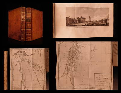
Sold20201787 1st ed Voyages in Syria & EGYPT Africa Illustrated1787 1st ed Voyages in Syria & EGYPT Africa Illustrated MAPS Sphinx 2v Volney “The best expose of Ottoman Empire at the end of the 18th-century!” (Blackmer) Constantin-François Volney, an 18th-ceSee Sold Price
Sold2018Pierre Tardieu Atlas, Twenty-Six Maps 1799-1800Pierre Tardieu Atlas with all maps dated 1799 or 1800. Contains twenty-six engraved maps on individual pages with blank backs. Sheet sizes are 10 13/16" x 16" (27.5cm x 41.5cm). Includes Egypt, FrenchSee Sold Price
Sold20231800 Payne Map of Poland -- PolandTitle: 1800 Payne Map of Poland -- Poland Cartographer: J Payne Year / Place: 1800, New York Map Dimension (in.): 7.5 X 8.5 in. This is a handsome map of poland. The claims of part of its lands by PruSee Sold Price
Sold20231800 Payne Map of England and Wales -- England and WalesTitle: 1800 Payne Map of England and Wales -- England and Wales Cartographer: J Payne Year / Place: 1800, New York Map Dimension (in.): 7.2 X 8.3 in. This is a lovely map of England and Wales. IdentifSee Sold Price
Sold2016The World Map from The Best Authorities 1799Map: The World from The Best Authorities. Rollinson Fct. Maker: William Rollinson Size: Double Octavo - 7.5 inches wide Date: 1799 Engraved for the New Encyclopedia. World in joined hemispheres. ZodiaSee Sold Price
Sold2018Tanner / Reid Map of South Carolina, 1796Tanner, Benjamin (1775-1848). State of South Carolina from the Best Authorities. Engraved map. J. Reid, 1796. 15" x 17" sheet. Published by John Reid New York. A very early and scarce folio map of SouSee Sold Price
Sold2018Africa from the Best Authorities.Title/Content of Map: Africa from the Best Authorities. Date: 1790 Cartographer: KITCHIN, T. Size: 7.25X8.8 Illustration map from Guthrie's Geography. Rather detailed. Polar projection Please note thaSee Sold Price
Sold2018Morse Map of GeorgiaMorse, Jedidiah (1761-1826). Map of Georgia, Also the Two Floridas, from the Best Authorities. Engraved map. Thomas & Andrews, 1796. 7¼" x 21⅛" sheet.See Sold Price
Sold2018Asia from the Best Authorities. by Tho. Kitchin Geo.Title/Content of Map: Asia from the Best Authorities. by Tho. Kitchin Geo. Date: 1762 Cartographer: KITCHIN, THO. Size: 5.8X7.3 From an English geography. Modern coloring. Light browning. Please noteSee Sold Price
Sold2018Kitchin: Antique Map of Africa, 1790Title/Content of Map: Africa from the Best Authorities. Date Printed: 1790 Cartographer: KITCHIN, T. Size (inches): 19x25.3 Illustration map from Guthrie's Geography. Rather detailed. Polar projectionSee Sold Price
Sold2018Africa, from the Best Authorities.Title/Content of Map: Africa, from the Best Authorities. Date Printed: 1806-01-01 Cartographer: BARLOW, J. sculp. Size: 7.25x8.1 Polar projection. From Rev. E. Blomfield's geography, A general view ofSee Sold Price
Sold2022AN ANTIQUE MAP OF SUFFOLK from the best authorities by Cary. 72 cm x 58 cm.AN ANTIQUE MAP OF SUFFOLK from the best authorities by Cary. 72 cm x 58 cm.See Sold Price
Sold2023Antique Map - West Indies - European Settlements - North & South America"The West Indies Exhibiting the English French Spanish Dutch & Danish Settlements with the adjacent Parts of North & South America from the best Authorities 1777". Interesting map of Florida, the CariSee Sold Price
Sold20231806 Hand Colored Map of Cornwall, John Cary1806 Map of Cornwall, England by John Cary (1755-1835). Copper plate map titled "A Map of Cornwall from the Best Authorities". Detailed hand colored map with Scilly Islands inset. Good condition, setSee Sold Price
Sold2021Guthrie, William 1798 Map. Canada North America"British Colonies in North America from the best Authorities" Copper Engraved Map Published 1798, London for "A New Geographical, Historical and Commercial Grammar..." by William Guthrie. The maps areSee Sold Price
Sold2017Russell: Antique Map of Europe, 1799Map: Europe, Drawn from the Best Authorities... Publication Date: 1799-04-07 Authors: C. DILLY/G.G. & J. ROBINSON, RUSSELL, J./RUSSELL JR. Publisher: C. DILLY/G.G. & J. ROBINSON Size: Folio – 15.25See Sold Price
Sold2021Guthrie, William 1798 Map. General Map of North America"A General Map of North America from the best Authorities" Copper Engraved Map Published 1798, London for "A New Geographical, Historical and Commercial Grammar..." by William Guthrie. The maps are bySee Sold Price
Sold2017Carey: Geographical & Statistical Map of Europe, 1822Geographical and Statistical Map of Europe. M. Carey, Young & Delleker 1822. Restriking of map, Europe: drawn from the best authorities for the illustration of Lavoisne's genealogical, historical, chrSee Sold Price
Sold2018West Indies from the Best Authorities.Reserve Reduced! Title/Content of Map: West Indies from the Best Authorities.Date: 1807 Cartographer: BARLOW, sculp. Material/Medium: C. BRIGHTLY & J. KINNERSLEY Size: 7.5 x 12.25 inches From Rev. E.See Sold Price
Jun 23Claydon Auctioneers LtdMap: A 19thC engraved map titled Gloucestershire from the Best Authorities, after John Cary. Approx.£20
5 days LeftJasper521801 Cary Map of Austria -- A New Map of the Circle of Austria from the Best Authorities$95
Jun 23Claydon Auctioneers LtdMap: An 18thC engraved map of England and Wales, laid on linen and sectionalised with slip cover.£60
BonhamsSPILSBURY (FRANCIS B.) Picturesque Scenery in the Holy Land and Syria, FIRST EDITION, Edward Orm...£600(1 bid)
Jun 27Rail & Road AuctionsChicago, North Shore & Milwaukee Railroad North Shore Line Playing Cards$50
Jun 23Schilb Antiquarian Rare Books1848 Emory Military Reconnaissance 1ed California MAP Indians Texas New Mexico$4(4 bids)
2 days LeftBazaar of PersiaCANAL ZONE block (US Stamp) 1904 Map of Panama Ovpt. 5c blue Sc#12 MNH$400
2 days LeftPalmyra Heritage GalleryAncient Egyptian Bronze Osiris 26th-30th Dynasty, ca. 664-342 B.C.$1,200
BonhamsEGYPT - ANTIQUITIES [Description de l'Égypte, ou recueil des observations et des recherches...£400


![[MAPS] A LOT OF 7 MAPS OF NORTH AMERICA: [MAPS] A lot of 7 maps of North America, including: Barlow, *. North America from the BestAuthorities. Circa 1800. Hand coloured. 18cm X 22cm. Framed. ** Marshall, John. A Map of the Country which was](https://p1.liveauctioneers.com/1124/208511/106199204_1_x.jpg?height=310&quality=70&version=1624388585)