Sold2017RARE AND IMPORTANT KENTUCKY FOLK ART SCHOOL GIRL MAPS,RARE AND IMPORTANT KENTUCKY FOLK ART SCHOOL GIRL MAPS, LOT OF FIVE, descended in the Cowan and Craig families of Central Kentucky, including "A Map of the United States Drawn by Mary H. L. Craig at thSee Sold Price
Sold20231799 United States MAP 1ed Rochefoucauld Voyages in Canada INDIANS Saratoga1799 United States MAP 1ed Rochefoucauld Voyages in Canada INDIANS Saratoga La Rochefoucauld-Liancourts account of his voyage to the New World is an important perspective on America and Canada prior tSee Sold Price
Sold20241844 Harper Library United States Poland Navigation MAPS 14v Voyages RARE LOT1844 Harper Library United States Poland Navigation MAPS 14v Voyages RARE LOT The Harper Family Library consists of hundreds of volumes of iconic and important history books – a set designed for schSee Sold Price
Sold20181846 1st ed Plymouth PILGRIMS Colonial Americana1846 1st ed Plymouth PILGRIMS Colonial Americana Mayflower Indians MAP William Russell’s account of early, Colonial Americana is an important look into United States history. “Guide to Plymouth”See Sold Price
Sold20211849 Wilkes Pacific US Expedition FIJI MAP Pacific1849 Wilkes Pacific US Expedition FIJI MAP Pacific Islands Australia Illustrated The ‘Wilkes Expedition’ was one of the most important exploration voyages ever taken on by the United States. It heSee Sold Price
Sold20191855 Plymouth Pilgrims Memorial Colonial Americana1855 Plymouth Pilgrims Memorial Colonial Americana Mayflower Indians War MAP William Russell’s account of early Colonial America is an important look into United States history. “Pilgrim MemorialsSee Sold Price
Sold20191862 1ed War with South CIVIL WAR Military Tomes1862 1ed War with South CIVIL WAR Military Tomes Illustrated Gettysburg MAPS The American Civil War played an important role in the expansion and growth of book publication in the United States, as peSee Sold Price
Sold2024Ohio copy of Mathew Carey’s 1796 GENERAL ATLASCarey, Mathew (publisher). CAREY’S GENERAL ATLAS. Philadelphia: Printed by Mathew Carey, May 1, 1796. FOLIO (14.75 x 9.5 inches), COMPLETE AS PUBLISHED (including a Rare Map of The United States bySee Sold Price
Sold2016JOHN MELISH (SCOTLAND/AMERICAN 1771-1822), EARLY ANDJOHN MELISH (SCOTLAND/AMERICAN 1771-1822), EARLY AND RARE MAP OF THE UNITED STATES OF AMERICA, C.1813. ENTERED AS THE ACT DIRECTS AND PUBLISHED BY JOHN MELISH, PHILADELPHIA, JUNE 1813. SIGHT 13 X 17 1See Sold Price
Sold2024Rare Hand-coloured Map - Florida - Louisiana - United States - BellinIts finely engraved, hand-coloring engraved map from the Dutch edition of acques Nicolas Bellin "Histoire General of Travel". Published in Amsterdam, 1770 year. Carte de la Floride de la LouSee Sold Price
Sold2020Minnesota territory, showing a large area of the upperTitle: Minnesota territory, showing a large area of the upper Midwestern states. RARE & important map 1850 by Thomas Date/Period: c1850 Materials: Hand colored steel engraved Size: 16 1/2 x 13 1/2 incSee Sold Price
Sold2021Fascinating 1852 map of U. S. w/western territoriesImportant transitional map of the United States showing terrific western territorial borders including the important territorial acquisitions of the Mexican-American War, pre-Gadsden Purchase. Inset mSee Sold Price
Sold2021Rare c1780s U. S. map showing FrankliniaRare and unusual map of the United States showing early borders of various states. The seller has not been able to locate another copy of this map. The map appears to either be a source for, or copy oSee Sold Price
Sold20201873 Geological Map of the United States Compiled byThis colorful map of the United States was compiled by Professors C.H. Hitchcock and W.P. Blake and is one of the most important early geological maps of the United States, one which would be copied bSee Sold Price
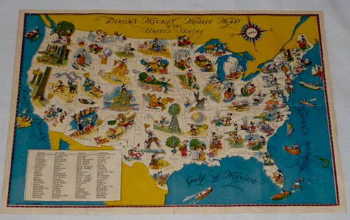
Sold2022Walt Disney Dixon's Mickey Mouse Map of United StatesEarly Disneyana collectible map. Copyright Walt Disney Enterprises 1935. Rare early pictorial map of the United States , richly illustrated with Disney character vignettes in each of the 48 states, MiSee Sold Price
Sold20191872 1st ed Report on Ku Klux Klan Conspiracy US1872 1st ed Report on Ku Klux Klan Conspiracy US Congress Racism American South An extremely rare and important history of the United States Congressional reports on the Ku Klux Klan. These reports, wSee Sold Price
Sold2023WWII 1944 United States Army Air Forces AAF Installations RARE Restricted MapWWII 1944 Army Air Forces AAF Installations Main Bases and Sub Bases in the Continental United States. RARE Restricted Map. Approximate size is 32 x 20 inches. Nice condition for its age.See Sold Price
Sold2023Rare 19thc Census Map, U.S. Agricultural ProductionExtremely rare, original 1876 atlas map of the United States Agriculture Production - five agricultural maps (in inset form) of the production of wheat, hay, corn, cotton and tobacco. Each map distingSee Sold Price
Sold2018Benjamin Warner Map of United States Philadelphia, 1820Benjamin Warner's map of the United States of America corrected and improved from the best authorities, 1820. Published by B.Warner, Philadelphia. Dimensions: Framed: 21 inches x 28.5 inches, Sight: 1See Sold Price
Sold20221864 Civil War MAP United States Statistics Commerce1864 Civil War MAP United States Statistics Commerce American Trade Gold Silver The United States Department of Treasury published this Civil War-era report analyzing the commerce of the US GovernmentSee Sold Price
Sold20221872 Vermont Directory MAP United States Constitution1872 Vermont Directory MAP United States Constitution Government Color The Directory, Rules Constitutions and Manual of Parliamentary Practice was a regularly published government periodical from VermSee Sold Price
Sold20211849 President Zachary Taylor on INDIANS Navajo1849 President Zachary Taylor on INDIANS Navajo Seminole Florida Gold Rush MAP United States Congressional reports and messages have long been a popular and highly desirable commodity, especially thosSee Sold Price
Sold20211873 Geography ATLAS MAPS United States Weather Owned1873 Geography ATLAS MAPS United States Weather Owned by Communist Spy ‘An Elementary Treatise on Physical Geography’ is a late 19th-century atlas and geography treatise. Collected by D.M. Warren,See Sold Price
Sold20231894 ALASKA California 18 MAPS United States Geodetic Surveys State Boundaries1894 ALASKA California 18 MAPS United States Geodetic Surveys State Boundaries Throughout the 19th-century, the United States government published countless reports and surveys on natural history of ASee Sold Price
Jun 13Swann Auction Galleries(UNITED STATES.) John M. Atwood. Phelps's National Map of the United States, A Travellers Guide.$450
4 days LeftTrillium Antique Prints & Rare BooksKohler & Weigel - Map of Louisiana Territory or Eastern United States (extends from New Mexico to$120(4 bids)
Jun 23Schilb Antiquarian Rare Books1888 Civil War 1st ed General Sheridan Personal Memoirs Union Native Americans$20(5 bids)
4 days LeftSimpson Galleries, LLC.JULIUS BIEN (1826-1909) AN AMERICAN CIVIL WAR RECONNAISSANCE MAP, "Map of Texas and Part of New$100
4 days LeftEarly American History Auctionsc 1797 Extremely Rare JOHN ADAMS President of the United States, Liverpool Creamware Bowl Choice EF$2,400
4 days LeftEarly American History Auctionsc 1797 JOHN ADAMS, President of the United States of America. Historical Liverpool Creamware Pitcher$2,000
4 days LeftEarly American History Auctions1837-Dated, Rare Small Size Martin Van Buren Indian Peace Bronze Medal NGC MS-64$400
Jun 12Dan Morphy AuctionsGEOLOGY OF THE BLACK AND GRAND RAPIDS OF TEXAS INCLUDING THE EASTERN AND WESTERN CROSS TIMBERS,$100
2 days LeftHolabird Western Americana CollectionsExploratory Travels Western Territories of North America, 1889 [181935]$200
4 days LeftTrillium Antique Prints & Rare BooksWilson - Flamingo, Wood Ibis, Scarlet Ibis, & White Ibis. 66$75


![Nevada Ore Deposit Map, 1866 [173205] (1 of 1)](https://p1.liveauctioneers.com/2699/331499/178846263_1_x.jpg?height=282&quality=70&version=1717095214)
![Exploratory Travels Western Territories of North America, 1889 [181935] (1 of 5)](https://p1.liveauctioneers.com/2699/331494/178785474_1_x.jpg?height=282&quality=70&version=1717094654)


