Sold2023Map of 1859 Prussia and Saxony by ColtonTitle: Map of 1859 Prussia and Saxony by Colton Date/Period: 1859 Materials: Steel engraved Size: 17 1/2 x 14 1/2” Prussia and Saxony. 1859. By J. H. Colton & G. W. Colton. From "General Atlas".See Sold Price
Sold2023Map of 1859 Switzerland by ColtonTitle: Map of 1859 Switzerland by Colton Date/Period: 1859 Materials: Steel engraved Size: 17 1/2 x 14 1/2” Switzerland. 1859. By J. H. Colton & G. W. Colton. From "General Atlas". Published inSee Sold Price
Sold20241859 Map of Netherlands & Belgium by ColtonTitle: 1859 Map of Netherlands & Belgium by Colton Date/Period: 1859 Materials: Steel engraved Size: 17 1/2 x 14 1/2” Netherlands & Belgium. 1859. By J. H. Colton & G. W. Colton. From "General ASee Sold Price
Sold2023Map of 1859 Brazil and Guyana’s by ColtonTitle: Map of 1859 Brazil and Guyana’s by Colton Date/Period: 1859 Materials: Hand colored steering engraved Size: 17 1/2 x 14 1/2” Brazil & Guyana’s. 1859. By J. H. Colton & G. W. CSee Sold Price
Sold20231859 Map of Florida by ColtonTitle: 1859 Map of Florida by Colton1859 Materials: Steel engraved Size: 17 1/2 x 14 1/2” Florida with Florida keys in the insert. From before the civil war. By J. H. Colton & G. W. Colton. From "GeSee Sold Price
Sold20231859 Map of Illinois, with Chicago, insert by ColtonTitle: 1859 Map of Illinois, with Chicago, insert by Colton Date/Period: 1859 Materials: Steel engraved Size: 17 1/2 x 14 1/2” Illinois with an insert of Chicago. By J. H. Colton & G. W. Colton.See Sold Price
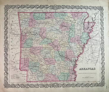
Sold20231859 Map of Arkansas by ColtonTitle: 1859 Map of Arkansas by Colton Date/Period: 1859 Materials: Steel engravedSize: 17 1/2 x 14 1/2” Arkansas. From before the civil war. By J. H. Colton & G. W. Colton. From "General Atlas".See Sold Price
Sold20231859 Map of England and Wales by ColtonTitle: 1859 Map of England and Wales by Colton Date/Period: 1859 Materials: Steel engraved Size: 17 1/2 x 14 1/2” England & Wales. By J. H. Colton & G. W. Colton. From "General Atlas". PublishedSee Sold Price
Sold20231859 Map of New Jersey by ColtonTitle: 1859 Map of New Jersey by Colton Date/Period: 1859 Materials: Steel engraved Size: 17 1/2 x 14 1/2” New Jersey. By J. H. Colton & G. W. Colton. From "General Atlas". Published in New YorkSee Sold Price
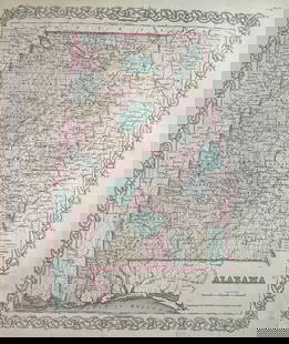
Sold20231859 Map of Alabama by ColtonTitle: 1859 Map of Alabama by Colton Date/Period: 1859 Materials: Steel engravedSize: 17 1/2 x 14 1/2” Alabama. From before the civil war. By J. H. Colton & G. W. Colton. From "General Atlas". PSee Sold Price
Sold20231859 Ireland by ColtonTitle: 1859 Ireland by Colton Date/Period: 1859 Materials: Steel engraved Size: 17 1/2 x 14 1/2” Ireland. 1859. By J. H. Colton & G. W. Colton. From "General Atlas". Published in New York. Hand-See Sold Price
Sold20231859. Canada east. By Colton>Title: 1859. Canada east. By Colton Date/Period: 1859 Materials: Hand colored steering engraved Size: 17 1/2 x 14 1/2” Canada east, or lower Canada. Insert of Montreal. 1859. By J. H. Colton & G. WSee Sold Price
Sold20231859 Iowa by ColtonTitle: 1859 Iowa by Colton Date/Period: 1859 Materials: Steel engraved Size: 17 1/2 x 14 1/2” Iowa. By J. H. Colton & G. W. Colton. From "General Atlas". Published in New York. Hand-colored, steSee Sold Price
Sold20231859 Michigan by ColtonTitle: 1859 Michigan by Colton Date/Period: 1859 Materials: Steel engravedSize: 17 1/2 x 14 1/2” Michigan. By J. H. Colton & G. W. Colton. From "General Atlas". Published in New York. Hand-colorSee Sold Price
Sold20231859 Georgia by Colton>Title: 1859 Georgia by Colton Date/Period: 1859 Materials: Steel engraved Size: 17 1/2 x 14 1/2” Georgia. From before the civil war. By J. H. Colton & G. W. Colton. From "General Atlas". PublishedSee Sold Price
Sold20231859 Mississippi by Colton>Title: 1859 Mississippi by Colton Date/Period: 1859 Materials: Steel engraved Size: 17 1/2 x 14 1/2” Mississippi. From before the civil war. By J. H. Colton & G. W. Colton. From "General Atlas". PuSee Sold Price
Sold20231859 Indiana by ColtonTitle: 1859 Indiana by Colton Date/Period: 1859 Materials: Steel engravedSize: 17 1/2 x 14 1/2” Indiana. By J. H. Colton & G. W. Colton. From "General Atlas". Published in New York. Hand-coloredSee Sold Price
Sold20241859 Missouri with St. Louis insert by ColtonTitle: 1859 Missouri with St. Louis insert by Colton Date/Period: 1859 Materials: Steel engraved Size: 17 1/2 x 14 1/2" Missouri with St. Louis insert. By J. H. Colton & G. W. Colton. From "General AtSee Sold Price
Sold20231859. St. Louis and Chicago by ColtonTitle: 1859. St. Louis and Chicago by Colton Date/Period: 1859 Materials: Steel engraved Size: 17 1/2 x 14 1/2? St. Louis and Chicago. By J. H. Colton & G. W. Colton. From "General Atlas". Published iSee Sold Price
20231859 Map of Florida by ColtonTitle: 1859 Map of Florida by Colton Date/Period: 1859 Materials: Steel engraved Size: 17 1/2 x 14 1/2” Florida with Florida keys in the insert. From before the civil war. By J. H. Colton & G. WSee Sold Price
Sold2016J. H. Colton: Oregon WashingtonMap: Colton's Washington and Oregon Maker: Joseph Hutchins Colton Publisher: G.W. & C.B. Colton & Co Size: Quarto, 12.75 inches high x 16 inches wide Date: 1857 Please note that this lot has a reserveSee Sold Price
Sold20191856 Map of Germany No.1 Colton Germany No. 1. (with) two inset maps: Hamburg and Bremen. Published By J.H. Colton & Co. No. 172 William St. New York. Entered ... 1855 by J.H. Colton & Co. ... New York. No. 12. Author: GW ColtoSee Sold Price
Sold2022Three Maps, Isle of Wight, East Indies, RussianComprising, Colton's East Indies, published by G.W., C.B. Colton & Co., Jeremiah Greenleaf's map of the Russian Empire, and J. Watt's map of Isle of Wight. Overall: 22-1/4"h x 25-1/2"w, 19"h x 21-3/4"See Sold Price
2023ANTIQUE 1854 J. H. COLTON s MAP of IOWA, HAND COLORED w HARD COVER FOLDERANTIQUE 1854 J. H. COLTON s MAP of IOWA, HAND COLORED w HARD COVER FOLDER Description 1854 Hand Tinted Watercolored Map of IOWA by J. H. COLTON. Map folds into hard covered folder. Printed census of ISee Sold Price
4 days LeftHolabird Western Americana CollectionsCalifornia Map by Colton in Frame, 1855 [180767]$150(1 bid)
4 days LeftHolabird Western Americana CollectionsPyramid Lake Print Pair & 1885 NM & UT Territory Map [179398]$150
5 days LeftConnoisseur AuctionsRare 19thc Colton Map, Argentine Republic, Chile, Uruguay, Pataguay$50
3 days LeftRapid Estate Liquidators and Auction Gallery1856 Mississippi Map & Info Published By J.H. Colton & Co. No.172 William St. New York$5
3 days LeftPiguet Hôtel des VentesHubert Robert (1733-1808), Vue du forum d'Auguste à Rome, sanguine sur papier, signée, localiséeCHF 12,000
23 hrs LeftHeritage Auctions61129: Joseph Foxcroft Cole (American, 1837-1892) Lands$500
4 days LeftCapitoliumart s.r.l.MARIO BELLINI Amanta pair of lounge chairs and coffee table for B&B Italia.€200
5 days LeftBrzostek’s Auction Service, Inc.Antique Seneca-Cayuga Wall map 1859 by Arz Dawson, Philadelphia$10
5 days LeftBrzostek’s Auction Service, Inc.Antique Seneca-Cayuga Wall map 1859 by Arz Dawson, Philadelphia$10(1 bid)
Jun 25Liberty & 33rd Furniture Co.L. & J. G. Stickley Antique Mission Oak Arts & Crafts Buffet Server or Writing Desk, Circa 1900$500
Jun 25Liberty & 33rd Furniture Co.L. & J. G. Stickley Antique Mission Oak Arts & Crafts Drop Front Secretary Desk, Circa 1900$500
2 days LeftJasper52NORTHERN AFRICA. Morocco Tunisia Algeria. Caravan routes. RAPKIN/TALLIS 1851 map$45
2 days LeftJasper52NORTHERN AFRICA. Morocco Tunisia Algeria. Caravan routes.TALLIS/RAPKIN 1851 map$45


![California Map by Colton in Frame, 1855 [180767] (1 of 3)](https://p1.liveauctioneers.com/2699/331495/178785753_1_x.jpg?height=282&quality=70&version=1717094933)

![Pyramid Lake Print Pair & 1885 NM & UT Territory Map [179398] (1 of 2)](https://p1.liveauctioneers.com/2699/331495/178785761_1_x.jpg?height=282&quality=70&version=1717094933)


![Arizona Library (5) 1915-67 [182280] (1 of 9)](https://p1.liveauctioneers.com/2699/331494/178785508_1_x.jpg?height=282&quality=70&version=1717094654)


