Sold20211861 Map of GermanyAuthor: Johnson Title: 1861 Map of Germany Medium: Ink on Paper Dimensions: 18"X13.5" Map of Germany dated 1861. Engraved by A.J. Johnson dated 1861. Published by Johnson and Ward in New York. CaptureSee Sold Price
Sold2018Germany's north central region. Insert of Hamburg &Germany's north central region. Insert of Hamburg & Bremen 1861 J.H. Colton 17 1/2" x 13 3/4" Hand colored steel engraved Map. From 'Colton's General Atlas.' Published in New York. Please note that thSee Sold Price
Sold20211861 MAP OF COAST OF SOUTH CAROLINAOriginal 1861 Frank Leslies Illustrated News Coast of South Carolina Wood Engraving with later hand coloring. Professionally framed. In frame measures 28"x31"x1". Weight 9 pds. NO IN HOUSE SHIPPING. PSee Sold Price
Sold20231861 Map of the United StatesAn oversize hanging map of the United States printed in Washington DC and dated 1861 showing the state boundaries, major cities and geographic features. These maps were used particularly in the earlySee Sold Price
Sold2019WILHELM HARSING (b. 1861, Germany) LandscapeOil on board 12 3/4 x 9 in., 16 x 12 in. (framed). Some provenance written on the back.See Sold Price
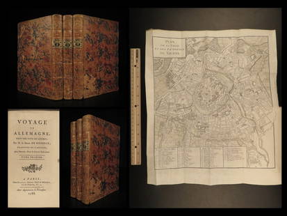
Sold20221788 Voyages Germany MAP Johann Riesbeck Letters Munich Vienna Austria 3v SET1788 Voyages Germany MAP Johann Riesbeck Letters Munich Vienna Austria 3v SET Johann Kaspar Riesbeck was a 18th-century German travel writer best-known for his book Letters from a French traveler in GSee Sold Price
Sold2021Antique Germany mapAntique Germany map depicting harbor scene with castles, 10.85"x15.5"See Sold Price
Sold2018Large/scarce 1861 map of New York BayReserve Reduced! Large and scarce 1861 coastal map of New York City and its harbor. One of the earliest 19th century charts to depict New York City as we know it today. It shows Manhattan, Brooklyn anSee Sold Price
Sold2024Johnson's South America. Bolivia with Littoral. Navigators' routes 1861 mapCAPTION PRINTED BELOW PICTURE: 'Johnson's South America' DATE PRINTED: 1861 IMAGE SIZE: Approx 65.5 x 45.5cm, 25.75 x 18 inches (Large); Please note that this is a folding map. TYPE: Large, decorativeSee Sold Price
Sold2023Johnson's Brazil, Argentine Republic, Paraguay & Uruguay. South America 1861 mapTitle: Johnson's Brazil, Argentine Republic, Paraguay & Uruguay. South America 1861 map Description: Johnson's Brazil, Argentine Republic, Paraguay and Uruguay' by Alvin Jewett Johnson (1861). Large,See Sold Price
Sold20201861 Map of MaineAuthor: Johnson Title: 1861 Map of Maine Medium: Ink on Paper Dimensions: 14.5"X18" Map of Maine dated 1861. Engraved by A.J.Johnson. Published by Johnson and Ward in New York. Map key located lower rSee Sold Price
Sold2017Fimbiae Vulgo Femeren, Island Germany Map, Blaeu, 1667TITLE/CONTENT OF MAP: 'Fimbiae vulgo Femeren delineatio geometrica [Fimbiae commonly known as Fehmarn (Femern)]' Other places marked or shown on the map include Borg (Burg auf Fehmarn), Peterstorp (PeSee Sold Price
Sold2023Johnson's Central America. Guatemala Honduras Nicaragua Costa Rica 1861 mapTitle: Johnson's Central America. Guatemala Honduras Nicaragua Costa Rica 1861 map Description: Johnson's Central America // Isthmus of Panama // Harbor of San Juan de Nicaragua // The "Nicaragua RoutSee Sold Price
Sold2023Johnson's Cuba, Jamaica & Porto Rico. Puerto Rico. Bahamas Florida Keys 1861 mapTitle: Johnson's Cuba, Jamaica & Porto Rico. Puerto Rico. Bahamas Florida Keys 1861 map Description: Johnson's Cuba, Jamaica and Porto Rico' by Alvin Jewett Johnson (1861). Large, decorative hand coloSee Sold Price
Sold20171861 Map of Kansas, Nebraska & Colorado, Mitchell, Jr1861 Map of Kansas, Nebraska and Colorado, showing also the southern portion of Dacotah. S Augustus Mitchell, Jr. 11.5 x 14.5 inches. A beautiful example of S. A. Mitchell Junior's 1866 map of KanSee Sold Price
Sold20221861 Map of Western US -- Reduced Section of NorthTitle: 1861 Map of Western US -- Reduced Section of North America Including all the Recent Geographical Discoveries Cartographer: US Government - Senate Date/Place: 1861, Washington Dimensions: 7.1 XSee Sold Price
Sold20231861 Map of Kentucky & Tennessee. By Johnson and BrowningTitle: 1861 Map of Kentucky & Tennessee. By Johnson and Browning Date/Period: 1861 Materials: Steel engraved Size: 26 x 18” 1861, by Johnson and Browning. From ‘New Illustrated Family AtlaSee Sold Price
Sold2024Johnson's Asia. Bod or Tibet. Toorkistan Cabool Birmah Persia Corea 1861 mapCAPTION PRINTED BELOW PICTURE: 'Johnson's Asia' DATE PRINTED: 1861 IMAGE SIZE: Approx 33.5 x 41.5cm, 13.25 x 16.25 inches (Large) TYPE: Large, decorative hand coloured 19th century atlas map CONDITIONSee Sold Price
Sold20201861 Germany (3). Southern German regions of BavariaTitle: 1861 Germany (3). Southern German regions of Bavaria and Wurttemberg. By Johnson Date/Period: 1861 Materials: Steel engraved. Size: 18x13” 1861. By A. J. Johnson & J. H Colton. From 'Johnson'See Sold Price
Sold20231861 Map of Italy by Johnson and BrowningTitle: 1861 Map of Italy by Johnson and Browning Date/Period: 1861 Materials: Steel engraved Size: 26 x 18” This 1861 map by Johnson and Browning depicts Italy, soon to be unified, in two partsSee Sold Price
Sold2022Germany Map; Handwritten Album; BookVintage map of Germany 1944; album with illustrated decals pasted in; and Die Denkmaler Berlins book. If lot is absent of a condition report one may be requested via email. Condition report is provideSee Sold Price
Sold20231861 Map of New Jersey. By Johnson and BrowningTitle: 1861 Map of New Jersey. By Johnson and Browning Date/Period: 1861 Materials: Steel engraved Size: 18x13” 1861, by Johnson and Browning. From ‘New Illustrated Family Atlas, with DescSee Sold Price
Sold20231861 Map of Illinois, by Johnson and BrowningTitle: 1861 Map of Illinois, by Johnson and Browning Date/Period: 1861 Materials: Steel engraved Size: 18x13” With an image of Chicago’s court house. 1861, by Johnson and Browning. From &#See Sold Price
Sold20241861 Map of Iowa and Eastern Nebraska. By Johnson and BrowningTitle: 1861 Map of Iowa and Eastern Nebraska. By Johnson and Browning Date/Period: 1861 Materials: Steel engraved Size: 18x13” 1861, by Johnson and Browning. From ‘New Illustrated Family ASee Sold Price
10 hrs LeftJasper521861 Map of Western US -- Reduced Section of a General Map of North America, Drawn from the Best$40
Featured1 day LeftJasper52Afrique…Nord-Ouest' & 'Inde' by Meissas. N Africa India Singapore 1861 old map$20
Featured1 day LeftJasper52Colonial West Africa. Nigeria Cameroon Congo. British German. TIMES 1900 map$20


![Fimbiae Vulgo Femeren, Island Germany Map, Blaeu, 1667: TITLE/CONTENT OF MAP: 'Fimbiae vulgo Femeren delineatio geometrica [Fimbiae commonly known as Fehmarn (Femern)]' Other places marked or shown on the map include Borg (Burg auf Fehmarn), Peterstorp (Pe](https://p1.liveauctioneers.com/5584/102908/52607369_1_x.jpg?height=310&quality=70&version=1492721880)


![Micrometer Calipers & Compass [181387] (1 of 6)](https://p1.liveauctioneers.com/2699/331494/178785671_1_x.jpg?height=282&quality=70&version=1717094654)


![Map of German Empire, c1800's [180903] (1 of 1)](https://p1.liveauctioneers.com/2699/331495/178785779_1_x.jpg?height=282&quality=70&version=1717094933)


