Sold20241875 Map of Harrisburg, PALarge 1875 city map of Harrisburg, PA in 400 feet to 1 inch scale. Map is matted and framed measuring approx 59.25" W x 39.35" H OD. Some loss, creases, and foxing are present on the map.See Sold Price
Sold20211875 Map fo the Eire Canal, West -- Map and Profile ofTitle: 1875 Map fo the Eire Canal, West -- Map and Profile of the Western Division of the Erie Canal Cartographer: New York State Government Year / Place: 1875 Map Dimension (in.): 24 X 58.6 in. ThisSee Sold Price
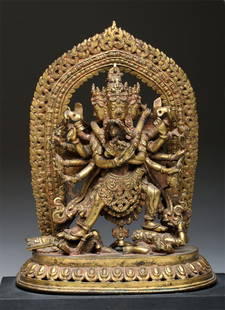
Sold201519th C. Nepalese Gilt Bronze Yab-Yum, Ex-Sotheby'sNepal, ca. 1875 CE. This incredibly detailed bronze gilded statue depicts Samvara, a protective Buddhist deity, embracing his shakti (female consort), Vajravarahi. They represent the concept of Yab-YuSee Sold Price
Sold2016Published 19th C. Mexican Painting - La AllegoriaLatin America, Mexico, ca. 1875 CE. A free standing, oil on wood retablo of La Alegoria de la Redencion (Allegory of the Redemption ). This superb rendition is painted on sabino, a very desirable woodSee Sold Price
Sold2015Published 19th C Mexican "La Allegoria de la Redencíon"Latin America, Mexico, ca. 1875 CE. A free standing, oil on wood retablo of La Alegoria de la Redencion (Allegory of the Redemption ). This superb rendition is painted on sabino, a very desirable woodSee Sold Price
Sold201718th C. French Map w/ Oiled Paper, ex-Sotheby'sEurope, France, map from 1709 CE, oiled paper overlays from 1756 to 1763 CE, owned by Louis-Alexandre Berthier (1753 to 1815 CE), Marshal, Vice-Constable of France, and Chief of Staff (Major general)See Sold Price
Sold2016[Map of Chatham County State ofGeorgia] by Charles G. Platen Savannah, 1875, a rare map of Chatham County, Georgia, one of the only maps on the county published in the 19th century, originally designed to promote agricultural develSee Sold Price
Sold20221820 MAP OF SALEM and 1875 of SALEM HARBOR28 x 36 inches and smaller Condition: Good, stiff, tearsSee Sold Price
Sold2022Boucheron, Les cinq sens, bracelet circa 1875 composé de 5 éléments ovales en or 750La fondation Horovitz a pour objectif d’accompagner les talents dans l’industrie de la joaillerie et de soutenir la formation continue en ce domaine. Elle est créée en 2020 pourSee Sold Price
Sold2022Atlas of PhiladelphiaAtlas of Philadelphia, 5th, 7th and 8th Wards, 1908, compiled and published by Elvino V. Smith, C.E., Philadelphia linen lacked paper, hardbound, features colored street maps with names and address foSee Sold Price
Sold2022JOSEF KOHLSCHEIN D.J. WINTER AM NIEDERRHEINJOSEF KOHLSCHEIN D.J. 1884 Duesseldorf - 1958 Neuss Winter at the Lower Rhine Oil on canvas. 56 x 66 cm (F. 64 x 74 cm). Signed lower right 'J. Kohlschein d.Jg.'. Part. abraded. Frame. JOSEF KOHLSCHEISee Sold Price
Sold2022John Smith Map of New England, Extremely Rare 2nd StateSMITH, John (1580-1631). New England the most remarqueable parts thus named by the high and mighty Prince Charles, Prince of great Britaine. Observed and described by Captayn John Smith... CopperplateSee Sold Price
Sold2015Colorado Springs, CT - Ch. 2179 - $5 Series 1875Here is the highlight of today's auction. Per territorial expert Peter Huntoon's article in the October Bank Note Reporter, this is the best and most exciting territorial discovery of the year. It couSee Sold Price
2021GREAT NORTHERN’S 2 GREAT TRAINS SYSTEM MAP.Huge dramatic reverse glass advertising Great Northern's two great trains, Empire Builder and Western Star. In script just below Great Northern logo it states "Steamliners twice a day, each way, betweSee Sold Price
Sold2022[STREETER COPY] SEARCY, I. G. Map of Florida constructed principally from authentic documents in the[STREETER COPY] SEARCY, I. G. Map of Florida constructed principally from authentic documents in the Land office at Tallahassee by I. G. Percy. Published by I.G. Searcy Tallahassee & F. Lucas Jr., BalSee Sold Price
Sold2023RARE Cheyenne Quilled & Beaded War Shirt Ca. 1875This is an astounding, rare and authentic circa 1875 hide painted war shirt with quillwork and beadwork from the Southern Cheyenne Native American Indians. This is truly a masterpiece of American IndiSee Sold Price
Sold2017Exceptional COWDEN & WILCOX / HARRISBURG, PA StonewareExceptional Five-Gallon Stoneware Jar with Profuse Bird-and-Floral Motif, Stamped "COWDEN & WILCOX / HARRISBURG, PA", circa 1865, large-sized, ovoid jar with tooled shoulder, applied lug handles, andSee Sold Price
Sold2022Kuba Corridor Carpet, Caucasus, ca. 1875Kuba Corridor Carpet, Caucasus, ca. 187515 ft. x 4 ft. 4 in.Provenance: The Collection of the late Peter H. Tillou, Litchfield, Connecticut.See Sold Price
Sold2020Gastaldi Map of Africa*** START PRICE IS THE RESERVE *** [Africa]. GASTALDI, Giacomo (1500-1566) & FORLANI, Paolo (fl. 1560-1571). La Descrittione dell'Africa. Engraved Map. Venice: Paolo Forlani, 1562. 19 x 25 1/4 inchesSee Sold Price
Sold2024Queen Marie of Romania (1875 - 1938) - a pair of gift cufflinksQueen Marie of Romania (1875 - 1938) - a pair of gift cufflinksFiligrane Fertigung aus 14-karätigem Gold (getestet, ungestempelt) mit Rubinbesatz. Chiffre in ovalem Rahmen, Maße mit Krone 18 x 16 mmSee Sold Price
Sold2016T-O World Map.- Lucanus (Marcus Annaeus) Pharsalia,Lucanus (Marcus Annaeus) Pharsalia, manuscript on paper, [Northern Italy (possibly Padua), first half of the fifteenth century]. 294 x 217mm., I + 149 + I leaves (including defective leaves and 3 blanSee Sold Price
Sold2024Petrus Plancius, Engraved World MapOrbis Terrarum Typus de Integro Multis in Locis Emendatus. Petrus Plancius (1552-1622). Copper-plate engraving with original hand color in full. Amsterdam, 1594. Some stains, creases, folds. Sight sizSee Sold Price
Sold2015A Fine & Rare Map of New York.Bernard Ratzer "Plan of the City of New York". Signed lower right in the plate "T. Kitchin Sculpt" (Kitchin recorded the cartographer's name as Ratzen (sic) rather than Ratzer). The map backed, rolledSee Sold Price
Jun 08Early American History AuctionsLot of Miscellaneous Printed Articles and Reproduction Souvenier Continental Army USA Design Buttons$100
1 day LeftJasper52La partie méridionale du Brésil et du Perou. SANTINI/D'ANVILLE 1784 old map$80
1 day LeftJasper52L'Amérique Méridionale by BRION DE LA TOUR. South America 1777 old map$35
4 days LeftLink Auction GalleriesDry, Camille, N. Pictorial St. Louis: The Great Metropolis of the Mississippi Valley. A$1,500
1 day LeftCedarburg Auction & Appraisals LLCSet of Four Maps Showing All of Spain and Portugal c. 1700's$450(2 bids)
1 day LeftCedarburg Auction & Appraisals LLCRare 1877 Double sided map of Milwaukee and Wisconsin$100(6 bids)


![[Map of Chatham County State of: Georgia] by Charles G. Platen Savannah, 1875, a rare map of Chatham County, Georgia, one of the only maps on the county published in the 19th century, originally designed to promote agricultural devel](https://p1.liveauctioneers.com/33/93309/47638095_1_x.jpg?height=310&quality=70&version=1472853562)


![[STREETER COPY] SEARCY, I. G. Map of Florida constructed principally from authentic documents in the: [STREETER COPY] SEARCY, I. G. Map of Florida constructed principally from authentic documents in the Land office at Tallahassee by I. G. Percy. Published by I.G. Searcy Tallahassee & F. Lucas Jr., Bal](https://p1.liveauctioneers.com/292/250642/130213737_1_x.jpg?height=310&quality=70&version=1654271664)


![Gastaldi Map of Africa: *** START PRICE IS THE RESERVE *** [Africa]. GASTALDI, Giacomo (1500-1566) & FORLANI, Paolo (fl. 1560-1571). La Descrittione dell'Africa. Engraved Map. Venice: Paolo Forlani, 1562. 19 x 25 1/4 inches](https://p1.liveauctioneers.com/1968/163248/82424552_1_x.jpg?height=310&quality=70&version=1583340284)

![T-O World Map.- Lucanus (Marcus Annaeus) Pharsalia,: Lucanus (Marcus Annaeus) Pharsalia, manuscript on paper, [Northern Italy (possibly Padua), first half of the fifteenth century]. 294 x 217mm., I + 149 + I leaves (including defective leaves and 3 blan](https://p1.liveauctioneers.com/5458/94966/48431616_1_x.jpg?height=310&quality=70&version=1476369049)


