Sold2022Scarce early Cram RR map of New YorkExceedingly scarce New York state map from the last Cram atlas to feature hand colored maps. “New Railroad and County Map of New York” from the very scarce 1882 Cram’s Unrivaled FamSee Sold Price
Sold2024Crams Railroad Map of New York-1881This is a Crams Railroad Map of New York dated 1881, Has a great fold-out full color map of the state of New York showing all railroad lines. Has almost no tears or frays. Booklet has 36 pages of counSee Sold Price
Sold2024Crams Township and Railroad Map of New York-1890This is a Crams Township and Railroad Map of New York dated 1890. Contains an excellent multi-paneled fold-out color map of the state with all railroads listed. Only a few very minor tears/frays at thSee Sold Price
Sold2019Early Roll-Up New York MapEarly roll-up New York map, "SCARBOROUGH'S / NEW / RAILROAD, POST OFFICE, TOWNSHIP / AND COUNTY MAP OF / NEW YORK". Imperfections. 48" x 41"See Sold Price
Sold2016scarborough's map of new york 19031903 Scarborough's new railroad, post office, township and county map of New York with distances between stations. Tears; stained; needs repair. 49 1/2 inches wide x 40 inches high.See Sold Price
Sold2021Antique New York State Map 1903 Color Roll Up RR Map1903 Scarborough's New Railroad, Post Office, Township and County Map of New York. Color map, compiled from the latest government and state surveys and original sources of the era. Insets: Map of NewSee Sold Price
Sold20231902 National Publishing Company Wall Map1902 roll down wall map printed by the National Publishing Company New Railroad, Post office, Township, and County Map of New York which measures approximately 48" by 41". Condition - fine.See Sold Price
Sold20201889 Map of New YorkAuthor: Cram Title: 1889 Map of New York Medium: Ink on PaperDimensions: 11.5"X14.5" Map of the lower half of New York City dated 1889. Engraved and published by George Cram in Chicago. Part of his StSee Sold Price
Sold2016RAILROAD MAPAMENDED LINE OF NEW YORK, SUSQUEHANNA & WESTERN RAILROAD - SUSSEX COUNTY, NEW JERSEY 48"X16"See Sold Price
Sold2022FRAMED 1914 RAILROAD MAP OF MAINEPresented by the Railroad Commissioners of Maine, showing steam railroad lines only, engraved and printed by George F. Cram of New York and Chicago. In modern black bullnose frame, under glass, 42" xSee Sold Price
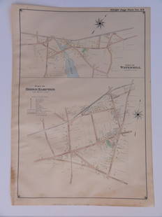
Sold2016Bridgehampton & Watermill, Long Island, 1902Original engraving published by E. Belcher Hyde from "Atlas of Suffolk County, Long Island, New York," Philadelphia, 1902. Map features family names, historic buildings and railroad routes. DimensionsSee Sold Price
Sold2015Town of Dover in Dutchess County, Atlas of New York byOriginal steel engraving by Augustus Mitchell, 1881. Map features city streets & railroads. Dimensions: 15” x 12”See Sold Price
Sold20211898 Cram Map of New York City -- Map of New York City…Title: 1898 Cram Map of New York City -- Map of New York City… Cartographer: G Cram Year / Place: 1898, Chicago Map Dimension (in.): 21.4 X 13.7 in. This is an excellent double-page map of ManhattanSee Sold Price
Sold20211898 Cram Map of New York City -- Map of New York andTitle: 1898 Cram Map of New York City -- Map of New York and Vicinity Cartographer: G Cram Year / Place: 1898, Chicago Map Dimension (in.): 18.8 X 12.2 in. This is an excellent double-page map of ManhSee Sold Price
Sold20211870 Mitchell Map of New York -- County Map of theTitle: 1870 Mitchell Map of New York -- County Map of the State of New York Cartographer: S Mitchell Year / Place: 1870, Philadelphia Map Dimension (in.): 13.7 X 21 in. This is an excellent map of theSee Sold Price
Sold20181876 Mitchell Map of New York -- County Map of theReserve Reduced! Title/Content of Map: 1876 Mitchell Map of New York -- County Map of the State of New York Date: 1876 Philadelphia Cartographer: S Mitchell Size: 13.5 x 21.3 in. A very nice, large maSee Sold Price
Sold2023M. Dripps 1860 Map New York City County & Vacinity By M. DrippsM. Dripps 1860 Map New York City County & Vacinity By M. Dripps 22.5" x 30"See Sold Price
Sold2017George Cram: Map of New York, 1906Map of New York. George Cram, Cram's Unrivaled Family Atlas of the World Indexed. 1906. 24 x 14.5 inches. Two sheets Please note that this lot has a confidential reserve. When you leave a bid in advanSee Sold Price
Sold2017George Cram: Map of New York, 1902New York, 1902 Original engraving from Pictoral Atlas of the World by George Cram, 1902. Dimensions: 14 1/2" x 22" inches. Please note that this lot has a confidential reserve. When you leave a bid inSee Sold Price
Sold20211878 Map of the New York Railroads -- Map of the RailTitle: 1878 Map of the New York Railroads -- Map of the Rail Roads of the State of New York Horatio Seymour Jr. Edward D. Smalley Cartographer: Seymour / Smalley Year / Place: 1878, Albany Map DimensiSee Sold Price
Sold20171875 Railroad Map Of New York1875 Railroad map of New York. Revised map of the railroads of State of N.Y.. Prepared under the direction of S.H. Sweet & D.M. Greene 1875. Hand colored. Folds as issued. 28 1/2" x 34 3/4".See Sold Price
Sold2022Scarce 1850 railroad map of New York by CowperthwaitSharp and colorful map of New York State with railroads highlighted by hand in orange-red to make them stand out. It is a testament to the importance of rail travel in the mid-19th century. Maps issueSee Sold Price
Sold20231894 Rand McNally Railroad Map of New YorkThis is an 1894 Rand McNally and Company Railroad Map of New York. Excellent condition for a 128 year old item! 63 inches by 51 inches. Paper on linen with vibrant colors! Comes with original metal seSee Sold Price
Sold2022Uncommon Railroad map of New York City, Rand McNallyHighly detailed map of Manhattan and the surrounding boroughs with special attention to Elevated Railroads, Metropolitan Railroads, Steamboat Piers and Railroad Piers. Steamship lines located and nameSee Sold Price
Jun 13Swann Auction Galleries(NEW YORK -- ADIRONDACK MOUNTAINS.) Seneca Ray Stoddard. Map of the Adirondack Wilderness.$375
Jun 13Swann Auction Galleries(PICTORIAL MAPS.) Annie Olmstead Peet; and Roscoe W. Smith. Orange County Before 1810.$300
Jun 13Swann Auction Galleries(NEW YORK.) Amos Lay. Map of the State of New York with Part of the States of Pennsylvania, New$500
Jun 13Swann Auction Galleries(NEW YORK CITY.) David Burr. Map of the City and County of New York with the Adjacent Country.$2,200
Jun 13Swann Auction Galleries(NEW YORK -- CATSKILL MOUNTAINS.) Edwin E. Howell. Relief map of Catskill Mountains.$450
Jun 13Swann Auction Galleries(MAINE.) J.H. Colton; and C.C. Hall. Railroad & Township Map of the State of Maine with Portions$375
3 days LeftEarly American History Auctions1836 Hand-Colored Map, Country Twenty Five Miles Round The City Of New-York Published by D.S. Stone$260
Jun 13Swann Auction Galleries(NEW JERSEY.) William Kitchell; and Robert Pearsall Smith. Topographical Map of the State of New$600
7 days LeftDan Morphy AuctionsPHELPS’S TRAVELERS GUIDE THROUGH THE UNITED STATES; CONTAINING UPWARDS OF SEVEN HUNDRED$1,000
JG AutographsRussell Sage - 19th Century Financier, Railroad Executive & Partner of Jay Gould - Autographed Card$25(1 bid)
2 days LeftHolabird Western Americana CollectionsCalifornia Eastern Extension Railroad Company Bond, 1859 [155354]$170
Jun 13Swann Auction Galleries(NEW YORK.) Ferdinand Mayer & Sons; [after Joseph H. Hidley?] Rensselaer Ville, N.Y.$450


![California Eastern Extension Railroad Company Bond, 1859 [155354] (1 of 1)](https://p1.liveauctioneers.com/2699/331495/178786281_1_x.jpg?height=282&quality=70&version=1717094933)


![(NEW YORK.) Ferdinand Mayer & Sons; [after Joseph H. Hidley?] Rensselaer Ville, N.Y. (1 of 1)](https://p1.liveauctioneers.com/199/332329/179231821_1_x.jpg?height=282&quality=70&version=1717450360)

