Sold20231876 Atlas of Illinois- Cook County Map Framed PagTravel back in time to the late 19th century with this enchanting Framed Map Page from the 1876 Atlas of Illinois by Warner & Beers. This exquisite piece showcases the detailed cartography of Cook, DuSee Sold Price
Sold2020Map of Cook and Dupage Counties, ChicagoMap of Cook and Dupage Counties in the city of Chicago bu Rufus Blanchard, dated 1872, There is a small tear on the bottom, In fair condition, Approx Size is 23" inches by 18" inchesSee Sold Price
Sold20171875 Map Cook, duPage, Kane, Kendall and Will Counties1875 Map Cook, duPage, Kane, Kendall and Will Counties - Atlas of Illinois Counties of Cook, duPage, Kane, Kendall and Will Counties Warner & Beers 1875 Chicago 20 x 23 in. Handsome map of the greaterSee Sold Price
Sold2018Antique Map - LondonAntique folding map "London in Miniature With The Surrounding Villages, An Entire NEW PLAN …." by Edward Mogg, published by Edward Mogg, No 51 Charing Cross, London made up of 20 paper panels laid dSee Sold Price
Sold2021Map, "London in Miniature with the SurroundingMap, "London in Miniature with the Surrounding Villages. An Entire New Plan in which the Improvements both present and intended are actually reduced (by permission) from the surveys of the Several ProSee Sold Price
Sold2021Vintage Pull Down Map Hearne Brothers Official ChicagoVintage 1960s Retractible Pull Down Map Hearne Brothers Official Chicago and Southern Cook County . Measures approx 48" x 68" Condition: Map is partially disconnected from the bottom rod. PleSee Sold Price
Sold2024Map Of New York City, 1839 Silk ScreenA silk screen print of a Map of New York City, 1839, showing surrounding villages, farms and estates. Prepared by Deans Who Were Established in that year. Approx 15,25 x 24.25 inches Moderate discolorSee Sold Price
Sold2019MAP - Indiana. MendenhallIndiana. Edward Mendenhall, A New Map of Indiana Exhibiting the Counties, Townships, Cities, Villages, and Post Offices. Rail Roads, Canals, and Common Roads, 1869 (dated). Hand Color. An attractive,See Sold Price
Sold2023TRAVEL 1926 SOUTHEAST ASIA w MAP, MALAYSIA & INDOCHINA by THOS. COOK & SONTRAVEL 1926 SOUTHEAST ASIA w MAP, MALAYSIA & INDOCHINA by THOS. COOK & SON TRAVEL 1926 SOUTHEAST ASIA w MAP, MALAYSIA & INDOCHINA by THOS. COOK & SON Description Old antique book titled; "MALAYSIA ANDSee Sold Price
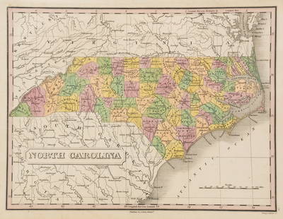
Sold2023Anthony Finley North Carolina Counties MapA Anthony Finley (American, 1784-1834) handcolored engraving depicting the counties within North Carolina and the surrounding areas. Stamped 'Published By A. Finley Phliad.' lower center. Presented inSee Sold Price
Sold2016MAP OF IOWA AND WISCONSIN, J.N. NICOLLET, 1844Hand tinted lithograph map from the map of J.N. Nicollet, 1844. Measures 13.75 x 18 inches overall. Depicts the Minnesota and Iowa territories, counties, native villages and trails.See Sold Price
Sold2021BRITISH MAP OF ENGLAND AND WALES NEEDLEWORK SAMPLERBRITISH MAP OF ENGLAND AND WALES NEEDLEWORK SAMPLER, silk on linen, oval vignette featuring the map of England and Wales with counties outlined and named, surrounding areas named including Scotland, ISee Sold Price
Sold2021Large Antique Hanging Map of Columbia County NY 1858Large Antique Hanging Map of Columbia County New York from 1858. Shows details and insets of towns and villages in Columbia county. Has a top piece made to hang on the wall. Has a beautiful patina andSee Sold Price
Sold2019MAP - Lake Geneva, Switzerland. Mercator/HondiusLake Geneva, Switzerland. Mercator/Hondius, Lacus Lemanus, 1610 (published). Hand Color. Handsome map of Lake Geneva with good detail of surrounding towns and villages. The large compass rose orientsSee Sold Price
Sold20231859 Map of Connecticut by ColtonTitle: 1859 Map of Connecticut by Colton Date/Period: 1859 Materials: Steel engraved Size: 17 1/2 x 14 1/2” Connecticut. Shows, rivers, lakes, counties cities, towns, villages, roads, and rail lSee Sold Price
Sold2018Group of New York State Historical MapsGroup of New York State Historical Maps. Map of Orleans County, NY, 1852 (40" x 47"); Map of Village of Albion, NY, 1857 (40" x 47"); Map of the State of New York, 1833 (21" x 25 1/2").. The RochesterSee Sold Price
2017Village of Scarsdale Westchester County NYMap: The Village of Scarsdale Westchester County New York Size: 28 x 22 inches Not framed Please note that this lot has a reserve. When you leave a bid in advance of the auction, submit your maximum.See Sold Price
Sold2022LINCOLNSHIRE Directories, etc:LINCOLNSHIRE Directories, etc: LINCOLNSHIRE Directories, etc: White, W: The History and Directory of the Towns and Principal Villages in the County of Lincoln. Leeds, 1826. No map present. Cont. fullSee Sold Price
Sold20231701 map of Ireland by Herman MollScarce and authentic map of Ireland. Coach roads and counties are shown. Towns and villages located and named. Bays, islands and other coastal features delineated. From Moll’s very scarce “A SysteSee Sold Price
Sold2017Jeremiah Greenleaf: Michigan MapMap: Michigan Description: This is a map of the young Michigan with Greenleaf's keyboard-style border, detailing the topography, color-coded counties, roads, towns and villages, and more. The countiesSee Sold Price
Sold2020Real estate for sale in Portola Valley, Cal.Heading: (California - San Mateo County) Author: Title: Map of Brookside Park near Stanford, San Mateo County, California Place Published: Palo Alto, CA Publisher:Aust Realty Co. Date Published:See Sold Price
Sold2020National Geographic Magazine July to Dec 1926National Geographic Magazine July to December 1926 Bound in one volume. Map is present. Blue cloth with leather spine title bands. Includes articles on Icebergs, WateSee Sold Price
Sold2022(NEW YORK -- WESTCHESTER COUNTY.) John Bute Holmes. Map of Edge-Water, Delancey's Neck, Long Island(NEW YORK -- WESTCHESTER COUNTY.) John Bute Holmes. Map of Edge-Water, Delancey's Neck, Long Island Sound Between the Villages of New Rochelle & Mamaroneck. To Be Sold at Auction by Anthony J. BleekerSee Sold Price
Sold2021Lovely 1854/56 Colton map of GeorgiaImpressive and clean 1854 map of Georgia from Colton's 1856 Atlas of the World. Highly detailed and hand colored by counties. Shows roads, railroads, towns, villages, post offices, rivers, lakes, statSee Sold Price
Featured2 days LeftJasper521878 Mitchell Map of Virginia and West Virginia [verso] New Jersey, Maryland and Delaware -- County$45
Jun 08Early American History Auctions1753 Map of the County of Lancaster Divided into its Hundreds, by Royal Mapmaker Emanuel Bowen$280
Jun 08Early American History Auctions1720 Colonial Northumberland County Virginia Manuscript Deed and Map Plot$400
2 days LeftThomaston Place Auction GalleriesEARLY 17TH C. ELIZABETHAN ENGRAVED MAP OF CORNWALL BY WILLIAM KIP AFTER WILLIAM SAXTON$150


![1878 Mitchell Map of Virginia and West Virginia [verso] New Jersey, Maryland and Delaware -- County (1 of 2)](https://p1.liveauctioneers.com/5584/329422/177662152_1_x.jpg?height=282&quality=70&version=1715717898)


