Sold2020Illustrated Van Loon Hand-Colored World Map, 1932Hendrik Willem Van Loon (Dutch-American, 1882-1944). Illustrated World Map, 1932. A hand colored outlined pictorial map of the world on Mercator projections with topographical relief shown pictoriallySee Sold Price
Sold2022Nat. Encyclo. C1875 Map. World HemispheresLithograph Map Published C1868-81 by William Mackenzie, London for "The National Encyclopedia: A dictionary of Universal Knowledge" Centre Fold as issued. Paper Size: 12 x 9.5 inch (31 x 24cm) Good CoSee Sold Price
Sold2023Nat. Encyclo. 1890's Large Map. World on Mercator's ProjectionSteel Engraved Map Published 1891-1901 by William Mackenzie, London for "The National Encyclopedia: A dictionary of Universal Knowledge" Folds as issued. Paper Size: 20.5 x 13.5 inch (52 x 33cm) A couSee Sold Price
Sold2022Nat. Encyclo. 1891 Antique Map. World HemispheresLithograph Map Published 1891-1901 by William Mackenzie, London for "The National Encyclopedia: A dictionary of Universal Knowledge" Centre Fold as issued. Paper Size: 12 x 9.5 inch (31 x 24cm) Good CSee Sold Price
Sold2022Wolters (Pub) 1932 LG World Hemisphere & Poles MapLithograph Map Published 1932 by J. B. Wolters, Groningen, Netherlands for "Bos-Niermeyer Schoolatlas der Geheele Aarde" by B. A. Kwast. Paper Size: 18 x 15 inch (46 x 38cm) Good ConditionSee Sold Price
Sold2022NATGEO Vintage Atlas of The World BookNATGEO Vntg Atlas of The World Book, copyright to 1981, measures 12 1/4 x 18 1/2 inches. Books, literature, coffee table looks, literature, adult literature, coffee table literature, NATGEO, NationalSee Sold Price
Sold20245 World & US Atlas Set Nat Geo, Rand McNallyNational Geographic Society Atlas Folio, 1958. National Geographic Atlas of the fifty United States, 1960. Firestone World Atlas, softcover, prepared by Rand McNally, 1942. Rand McNally's The World AfSee Sold Price
Sold2021Collection of 9 World History BooksCollection of 9 large historical books, coffee table sized. Includes atlases, Nat Geo. books, and a desert photography book by David Muench. *Books will be boxed and shipped Media Mail.See Sold Price
Sold2020Atlas - Kwast, Berend 1932 Schoolatlas, 45 Folio Maps"Bos-Niermeyer Schoolatlas der Geheele Aarde" by Berend Albertus Kwast. Groningen: J. B. Wolters, 1932. Folio (390 x 250mm) Complete with 455 Folding Lithograph Maps from around the World. ContemporarSee Sold Price
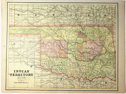
Sold2020Indian Territory 1891Title/Content of Map: Indian Territory 1891 Date Printed: 1891 Material/Medium: Paper Size: approx 10.5x14.5 inches Additional Info: Cram's Atlas of the World. Geo. F. Cram, Chicago Reserve: $20.00 SSee Sold Price
Sold2021Spain & Portugal 1891Title/Content of Map: Spain & Portugal 1891 Date Printed: 1891 Material/Medium: Paper Size: approx 11.5x14.5 inches Cram's Atlas of the World. Geo. F. Cram, Chicago Reserve: $30.00 Shipping: DomesticSee Sold Price
Sold2020Africa 1891Title/Content of Map: Africa 1891 Date Printed: 1891 Material/Medium: Paper Size: approx 21.5x14.5 inches Additional Info: Cram's Atlas of the World. Geo. F. Cram, Chicago Reserve: $25.00 Shipping: DSee Sold Price
Sold2020Italy 1891Title/Content of Map: Italy 1891 Date Printed: 1891 Material/Medium: Paper Size: approx 11x14.5 inches Additional Info: Cram's Atlas of the World. Geo. F. Cram, Chicago Reserve: $20.00 Shipping: DomeSee Sold Price
Sold2020Egypt, Arabia, Nubia 1891Title/Content of Map: Egypt, Arabia, Nubia 1891 Date Printed: 1891 Material/Medium: Paper Size: approx 11x14.5 inches Additional Info: Cram's Atlas of the World. Geo. F. Cram, Chicago Reserve: $20.00See Sold Price
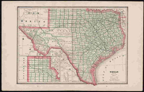
Sold2022Clean 1883 RR map of Texas, Geo. F. CramInteresting cerographic map of Texas from Cram’s Unrivaled Family Atlas of the World. Predates subdivision of Tom Green, Pecos, Crockett and Presidio Counties. Shows rail system throughout statSee Sold Price
Sold2022Wolters (Pub) 1932 Lot of 24 Vintage MapsIncl Europe, Netherlands, Scandinavia, World, UK, Spain/Portugal, Italy, Balkans, Asia, Alps, Germany, Switzerland, etc. Lithograph Maps Published 1932 by J. B. Wolters, Groningen, Netherlands for "BoSee Sold Price
Sold2023Nat. Encyclo. 1890's Mixed Lot of 32 Antique MapsIncl Sweden/Norway, Eastern USA, British Isles Geological, North America X 2, South America, Russia in Europe, Scotland, Britannia Antiqua, Suez Canal, China Proper, England and Wale, World HemisphereSee Sold Price
Sold2017Tallis World Map World on Mercator's Projection 1851Tallis World Map The World on Mercator's Projection 1851 . J. Tallis, 1851 London, 10.5 X 14 In.. This Is a Decorative and Striking Steel Engraved World Map That Was Produced from the Same Plate UsedSee Sold Price
Sold2016Map of Cleveland, Cram's Unrivaled Atlas of the WorldMap: Map of Cleveland Maker: George Franklin Cram From: Cram's Unrivaled Atlas of the World Map Origin: Chicago Date: 1889 Medium: Original lithograph printed in color Size: 11.5 x 14.5 inches PleaseSee Sold Price
Sold2016T-O World Map.- Lucanus (Marcus Annaeus) Pharsalia,Lucanus (Marcus Annaeus) Pharsalia, manuscript on paper, [Northern Italy (possibly Padua), first half of the fifteenth century]. 294 x 217mm., I + 149 + I leaves (including defective leaves and 3 blanSee Sold Price
Sold2024Petrus Plancius, Engraved World MapOrbis Terrarum Typus de Integro Multis in Locis Emendatus. Petrus Plancius (1552-1622). Copper-plate engraving with original hand color in full. Amsterdam, 1594. Some stains, creases, folds. Sight sizSee Sold Price
2022Blaeu, Johannes (Netherlands, 1596-1673) "The New World Map" Double Hemisphere World Map C. 1664Nova et Accuratissima Totius Terrarum Orbis Tabula Translated "The New World Map", Hand Colored w/ Elaborately Decorated Spandrels.   Sight View 16" x 21-1/2", Overall View 21" x 25-1/2"See Sold Price
Sold2018Ortelius' 1570 world mapHeading: Author: Ortelius, Abraham Title: Typus Orbis Terrarum Place Published: Antwerp Publisher: Date Published: 1570-[1584?] Description: Copper-engraved map, hand-colorSee Sold Price
2018Important World Map from the Nuremberg Chronicle, 1493Title/Content of Map: World Map from the Nuremberg Chronicle. One of the most important world Maps ever produced Date Printed: 1493 Cartographer: Hartmann Schedel Material/Medium: Paper Size: 18" x 25See Sold Price
13 hrs LeftJasper521833 Woodbridge World Map -- Map of the World Adapted to Woodbridge's Geography$40
13 hrs LeftJasper521881 Vuillemin World Map with French Colonies Shown -- Planisphere: Indiquant les Colonies Francises$30
2 days LeftActivity AuctionsRare 1976**Franklin Mint*Sterling Silver**925/Gold World Map Old Art Piece$1,100
5 days LeftWorthington Galleries19th c. Hemisphere World Map, Hohen und Tiefen der Erde in Lambert’s Zenithal-Projection von$10
Jun 15Fine Arts OutletYoung Couple Reviewing a World Map Bronze Statue - Size: 32"L x 47"W x 42"H.$3,150
Jun 13Swann Auction Galleries(WORLD.) Group of 6 eighteenth-century engraved double-hemispheric world maps.$900
5 days LeftWorthington Galleries18th c. Map OBSERVATIONS SUR LES POINTS CARDINAUX. LIGNES, ET CIRCLES DE LA SPHÈ$10


![T-O World Map.- Lucanus (Marcus Annaeus) Pharsalia,: Lucanus (Marcus Annaeus) Pharsalia, manuscript on paper, [Northern Italy (possibly Padua), first half of the fifteenth century]. 294 x 217mm., I + 149 + I leaves (including defective leaves and 3 blan](https://p1.liveauctioneers.com/5458/94966/48431616_1_x.jpg?height=310&quality=70&version=1476369049)


![Ortelius' 1570 world map: Heading: Author: Ortelius, Abraham Title: Typus Orbis Terrarum Place Published: Antwerp Publisher: Date Published: 1570-[1584?] Description: Copper-engraved map, hand-color](https://p1.liveauctioneers.com/642/127929/65081054_1_x.jpg?height=310&quality=70&version=1537227236)


