Sold20221960 Hawaiian Airlines Pictorial Route Map -- The Hawaiian IslandsTitle: 1960 Hawaiian Airlines Pictorial Route Map -- The Hawaiian Islands Cartographer: Hawaiian Airlines Year / Place: 1960 Map Dimension (in.): 8.9 X 20.2 in This is an attractive pictorial airlineSee Sold Price
Sold20181978 Hawaiian Airline Pictorial Map of Hawaii -- HawaiiTitle/Content of Map: 1978 Hawaiian Airline Pictorial Map of Hawaii -- Hawaii Date Printed: 1978 Cartographer: Hawaiian Airline Size: 12 x 18 in. A very nice pictorial map of Hawaii with air routes ofSee Sold Price
Sold20231950s Hawaiian Airline Route Map of Hawaii -- Hawaiian Airline Map of the State of HawaiiTitle: 1950s Hawaiian Airline Route Map of Hawaii -- Hawaiian Airline Map of the State of Hawaii Cartographer: Hawaiian Airline Year / Place: mid 1950s Map Dimension (in.): 9.2 x 24 in This is a verySee Sold Price
Sold20181957 Hawaiian Airlines Convair 340 Route Map --Title/Content of Map: 1957 Hawaiian Airlines Convair 340 Route Map -- Hawaiian Airlines Route Map Date: 1957 Cartographer: Hawaiian Airlines Size: 8.5 x 11.2 in. This is an attractive advertising showSee Sold Price
Sold2018Vintage Hawaiian Airline Route Map of Hawaii, 1953Title/Content of Map: 1953 Hawaiian Airline Route Map of Hawaii -- Hawaiian Airline Map of the State of Hawaii Date Printed: 1953 Cartographer: Hawaiian Airline Size: 9.2 x 21 in This is a very nice mSee Sold Price
Sold2017VINTAGE 1960's HAWAIIAN AIRLINES MAP OF HAWAII, GOODVINTAGE 1960's HAWAIIAN AIRLINES MAP OF HAWAII, GOOD VINTAGE CONDITION, FRAMED SIZE 16.75" X 12.5", SKU7540See Sold Price
Sold2018Hawaiian Airlines "See All Hawaii" Map and BrochureHawaiian Airlines "See All Hawaii" map and brochure.ÂSee Sold Price
Sold2022[MAPS]. -- [AIRLINES]. A dozen mid-20th century airline[MAPS]. -- [AIRLINES]. A dozen mid-20th century airline maps. Brochures for Air France, Air Rhodesia, American Airlines, British Airways, Hawaiian Airlines, Mexicana de Aviacion, Northwest Orient AirlSee Sold Price
Sold20231937 color pictorial map of Hawaiian IslandsHeading: (Hawaii) Author: Title: The Dole Map of the Hawaiian Islands, U.S.A.: Being a descriptive portrayal of the history, transportation, industries and geography of the Territory of Hawaii, U.S.ASee Sold Price
Sold20211950 Feher Pictorial Map of Hawaiian Islands for DoleTitle: 1950 Feher Pictorial Map of Hawaiian Islands for Dole Pineapples -- The Dole Map of the Hawaiian Islands Cartographer: J Feher Year / Place: 1950, Honolulu Map Dimension (in.): 18.8 X 28 in. ThSee Sold Price
Sold2021Color pictorial bird's-eye airline route maps 1929Heading: (Aviation - pictorial route maps) Author: Title: Western Air Express: Travel by Air, Speed - Comfort - Dependability Place Published: [California?] Publisher:Western Air Express Date PuSee Sold Price
Sold2022[HAWAII]. Group of 5 airline posters. Circa 1970s/80s. Trav...[HAWAII]. Group of 5 airline posters. Circa 1970s/80s. Travel poster advertisements for Canadian Pacific Airlines, Hawaiian Airlines, and United Airlines. Largest 40 x 25”. Unbacked. Scattered cSee Sold Price
Sold2021[HAWAII] Dole Pictorial Map of the Hawaiian Islands.[HAWAII] Dole Pictorial Map of the Hawaiian Islands. 1937. Offset lithograph. Scarce pre-war pictorial map of the islands, filled with vignettes of the natural and man-made landmarks, modes of transpoSee Sold Price
Sold2022Dole Pictorial Map of the Hawaiian Islands. 1937. Scarce pi...Dole Pictorial Map of the Hawaiian Islands. 1937. Scarce pictorial map of the islands, illustrated with natural and man-made landmarks, native and Western/colonial vessels and boats, attractions, withSee Sold Price
Sold2022FEHER, Joseph (1909-1987). Dole Pineapple / The Dole Map of the Hawaiian Islands. 1950.FEHER, Joseph (1909-1987). Dole Pineapple / The Dole Map of the Hawaiian Islands. 1950. Honolulu: Hawaiian Pineapple Company. Pictorial map depicting the islands of the soon-to-be 50th state with illuSee Sold Price
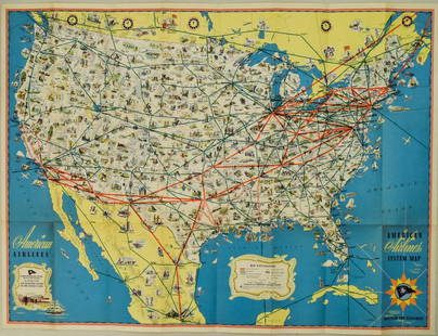
Sold20231950s American Airlines Route Map -- American Airlines Route MapTitle: 1950s American Airlines Route Map -- American Airlines Route Map Cartographer: American Airlines Year / Place: 1950s Map Dimension (in.): 12.5 X 19.2 in. joined This nice, large pictorial routeSee Sold Price
Sold2023Fly CAT / See Taiwan. Government Information Office, Republ...Fly CAT / See Taiwan. Government Information Office, Republic of China, ca. 1960s. Pictorial airline travel poster map of Taiwan. CAT’s routes and airports are marked with pink lines and red dotSee Sold Price
Sold2021Hawaii / Continental Airlines. Circa 1970s.Hawaii / Continental Airlines. Circa 1970s. Photographic poster of a beautiful Hawaiian woman smiling at the viewer. 23 ¼ x 16 ½”. Linen backed. A.See Sold Price
Sold20221940s American Airlines US Route Map -- American Airlines System MapTitle: 1940s American Airlines US Route Map -- American Airlines System Map Cartographer: American Airlines (General Drafting Co.) Year / Place: 1940s c. Map Dimension (in.): 24 X 32 in. Ths is an attSee Sold Price
Sold20191957 Quantas Airline Route Map -- Quantas AirlinesReserve Reduced! Title/Content of Map: 1957 Quantas Airline Route Map -- Quantas Airlines Route Map Date: 1957 Cartographer: Quantas Airlines Size: 11.2 x 8.3 in. This is a rather interesting advertisSee Sold Price
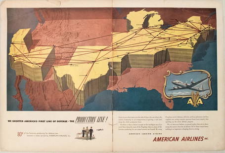
Sold20191949 American Airlines Route Map AdTitle/Content of Map: 1949 American Airlines Route Map Ad Date: 1949Cartographer: American Airlines Size: 13.6 X 21 in. when joined This is an attractive ad highlightingAmerican Airlines routes - servSee Sold Price
Sold2023PAN AMERICAN AIRLINES ROUTE MAP. "Fastest way between… USA & Latin America" 1935Title: PAN AMERICAN AIRLINES ROUTE MAP. "Fastest way between… USA & Latin America" 1935 Description: Consult this map for fastest way between all points in the United States and Latin America' bSee Sold Price
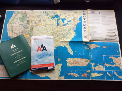
Sold2023Vintage American Airlines Route Map, American Airline Trip Book and BinderVintage American Airlines Route Map, American Airline Trip Book and BinderSee Sold Price
Sold2018United Airlines Route Map A Gay Geography of Main LineUnited Air Lines. A Gay Geography of the Main Line Airway. The Main Line Mid-Continental Airway published in 1939 route map. See Sold Price
6 days LeftThe Ross Art GroupOriginal Vintage Air France World Route Map Vickers Viscount Poster 1956 Constellation$600
6 days LeftThe Ross Art GroupOriginal Vintage Fly TWA Jets India Pink Elephant Poster by David Klein c1960$600(1 bid)
Jun 27Rail & Road AuctionsTen Gulf, Mobile & Ohio Railroad Playing Card Decks - Alton Route Map and Logo$70
Featured5 days LeftJasper52Hawaii & American Samoa. Pictorial state map by Ruth Taylor White 1935 old$140
Jun 29JM Hobby Supply and Railroad Artifact AuctionsFlorence & Cripple Creek RR Public Timetable-September 1894$400
Jun 27Rail & Road Auctions45 Peices of Western Railroad Paper Ephemera - Southern Pacific, Northern Pacific, Union Pacific,$30(1 bid)
BonhamsSPEED (JOHN) AND WILLEM BLAEU Pictorial title-pages to Speed's 'Theatre of the Empire of Great B...£30(3 bids)
6 days LeftThe Ross Art GroupOriginal Vintage United Air Lines Hawaii Woman with Lei Poster by Stan Galli$600
6 days LeftThe Ross Art GroupOriginal Vintage Stan Galli Poster United Air Line Hawaii Canoe c1960$1,000(1 bid)
BonhamsLOGGAN (DAVID) Cantabrigia illustrata sive omnium celeberrimae istius Universitatis collegiorum...£8,000(1 bid)


![[MAPS]. -- [AIRLINES]. A dozen mid-20th century airline: [MAPS]. -- [AIRLINES]. A dozen mid-20th century airline maps. Brochures for Air France, Air Rhodesia, American Airlines, British Airways, Hawaiian Airlines, Mexicana de Aviacion, Northwest Orient Airl](https://p1.liveauctioneers.com/928/230548/119288810_1_x.jpg?height=310&quality=70&version=1639776029)


![Color pictorial bird's-eye airline route maps 1929: Heading: (Aviation - pictorial route maps) Author: Title: Western Air Express: Travel by Air, Speed - Comfort - Dependability Place Published: [California?] Publisher:Western Air Express Date Pu](https://p1.liveauctioneers.com/642/204898/103985846_1_x.jpg?height=310&quality=70&version=1621652446)
![[HAWAII]. Group of 5 airline posters. Circa 1970s/80s. Trav...: [HAWAII]. Group of 5 airline posters. Circa 1970s/80s. Travel poster advertisements for Canadian Pacific Airlines, Hawaiian Airlines, and United Airlines. Largest 40 x 25”. Unbacked. Scattered c](https://p1.liveauctioneers.com/928/255324/132835924_1_x.jpg?height=310&quality=70&version=1658268357)
![[HAWAII] Dole Pictorial Map of the Hawaiian Islands.: [HAWAII] Dole Pictorial Map of the Hawaiian Islands. 1937. Offset lithograph. Scarce pre-war pictorial map of the islands, filled with vignettes of the natural and man-made landmarks, modes of transpo](https://p1.liveauctioneers.com/928/200564/101543113_1_x.jpg?height=310&quality=70&version=1618323144)