Sold2022Turkey.- Spencer (Edmund) Travels in European Turkey, in 1850, 2 vol., first edition, 1851; andTurkey.- Spencer (Edmund) Travels in European Turkey, in 1850, 2 vol., first edition, tinted lithograph frontispieces, vignette titles, large folding linen-backed map, ex-library with neat pencil noteSee Sold Price
Sold2021Alexandre Vuillemin, Plan Pittoresque de ParisAlexandre Vuillemin, Plan Pittoresque de Paris (1840). large, linen-backed folding map.Estimate: $100 - $200See Sold Price
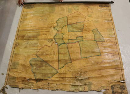
Sold2022MAP OF NORTHAMPTON COUNTY, PA 1860LINEN BACKED MAP. SMITH, GALLUP & CO. PUBLISHERS, PHILADELPHIA, 1860. MEASURES 56" X 57" Terms & Conditions: Pick-up for this Auction will be Wednesday August 3rd and Thursday August 4th from 9:00am tSee Sold Price
Sold2023F W BEERS & CO. 1870 large linen map of RONDOUT KINGSTON and WILBUR, ( has a later linen back andF W BEERS & CO. 1870 large linen map of RONDOUT KINGSTON and WILBUR, ( has a later linen back and quality custon frame ) has normal wear and crinkles, but overall in nice condition, was always well taSee Sold Price
Sold2021German Offensive On the Somme - March 1916 MapGerman Offensive On the Somme - March 1916 World War I One. Linen backed. Map 6 - Ordnance Survey - Large Map with Scale Publisher British Dated: 1919 Type:See Sold Price
Sold2021Battle of the Somme - 1916 MapBattle of the Somme - 1916 World War I One. Linen backed. Map 1 - Ordnance Survey - Large Map with Scale Publisher British Dated: 1919 Type: Colored MiltSee Sold Price
Sold2021Battle of Cambrai - Nov. Dec. 1917 MapBattle of Cambrai - November December 1917 World War I One. Linen backed. Map 5 - Ordnance Survey - Large Map with Scale Publisher British Dated: 1919 TypeSee Sold Price
Sold2021Third Battle of Ypres 1917 MapThird Battle of Ypres - Summer and Autumn 1917 World War I One. Linen backed. Map 4 - Ordnance Survey - Large Map with Scale Publisher British Dated: 1919 TSee Sold Price
Sold2021Final British Offensive August - November 1918 MapFinal British Offensive August to November 1918 World War I One. Linen backed. Map 8 - Ordnance Survey - Large Map with Scale Publisher British Dated: 1919See Sold Price
Sold2021The German Offensive on the Lys - April 1918 MapThe German Offensive on the Lys - April 1918 World War I One. Linen backed. Map 7 - Ordnance Survey - Large Map with Scale Publisher British Dated: 1919 TypSee Sold Price
Sold2021The German Retreat to the Hindenburg Line 1916 MapThe German Retreat to the Hindenburg Line 1916 - 1917 World War I One. Linen backed. Map 2 - Ordnance Survey - Large Map with Scale Publisher British Dated: 1919</See Sold Price
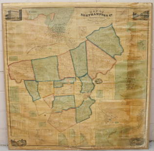
Sold2022MAP OF NORTHAMPTON COUNTY, PA 1860LINEN BACKED MAP MOUNTED ON BACKBOARD UNDER PLEXIGLASS (NO FRAMEWORK). SMITH,GALLUP & CO. PUBLISHERS, PHILADELPHIA, 1860. MEASURES 60" X 58". Terms & Conditions: Pick-up for this Auction will be WedneSee Sold Price
Sold2023Mrs. Potter, Large Victorian Linen Backed Theater PosterDescription: A large ca. 1900 linen-backed poster published by the Central Litho. & Eng. Co. New York, depicting Mrs. Potter, probably a theater actress or the subject of a play. Type: Poster MaterialSee Sold Price
Sold2022Universal Atlas 1893 Lot of 9 Large Maps of EuropeIncl Austrian Alps, Switzerland, Spain/Portugal, Austria/Hungary, Germany, France, England/Wales Lithograph Maps Published 1893 by Cassell & Co., London for "The Universal Atlas" Centre fold as issuedSee Sold Price
Sold2018Bartholomew's Large Scale Map of Central Europe.Title/Content of Map: Bartholomew's Large Scale Map of Central Europe. Date Printed: 1914 Cartographer: BARTHOLOMEW, JOHN & CO. Size: 23.5x35.25 [cover title] "General map showing European frontiers,See Sold Price
Sold2022Staffordshire.- Plot (Robert) The Natural History of Stafford-shire, first edition, Oxford, At theStaffordshire.- Plot (Robert) The Natural History of Stafford-shire, first edition, title with large engraved vignette, engraved plate of 'Armes omitted', folding map (linen-backed and inserted in pocSee Sold Price
Sold2024Map of the US, Colton, 1874 [179353]The New County map of the United States of America,[x=#8221/] drawn, engraved and printed by G. W. and C. B. Colton & Co., New York 1874. Very large multicolor map, linen back in original Colton bindiSee Sold Price
Sold2021Bruce, James 1813 Map of of the River Nile"Copper Plate Published 1813, Edinburgh for "Travels to discover the source of the Nile" by James Bruce. Paper Size: 21 x 12.5 inch (53 x 32cm) Very large closed tear, backed with Linen. Heavy toningSee Sold Price
Sold2022Cole Bros. Circus / Clyde Beatty. Erie: Erie Litho Co., ca....Cole Bros. Circus / Clyde Beatty. Erie: Erie Litho Co., ca. 1935. Half sheet poster depicting Clyde Beatty at the center of a large group of lions and tigers. 20 x 28”. Linen backed. Old folds,See Sold Price
Sold2018Air France. Large World Map Airways Route Poster.Masse, Jean. Air France. Large World Map Airways Route Poster. Paris: R. Graindorge/Perceval, ca. 1961. Color map of the world detailing the airline's routes. Linen backed. 45 ½ x 81". Small browSee Sold Price
Sold20221889 LARGE WALL MAP of HOLY LAND to ILLUSTRATE BIBLE antique 52 by 60" antiqueLarge Wall Map of The Holy Land to Illustrate both the Old and New Testaments. Size 60 x 52 inches linen-backed and lacquered, wooden rollers; margins chipped, some soiling, generally sound. Made in ESee Sold Price
Sold2024Flemming, Carl C1890 Large Map of Africa. German Colonial MapLarge Lithograph Map Published C1890, Glogau, Poland. Published for Carl Flemming's Generalkarten Series, No.43. Neatly Linen backed. Paper Size: 32.5 x 27.5 inch (83 x 70cm) Minor blue crayon marks iSee Sold Price
Sold2022Antique Map of Europe - Map of Ireland - Dublin - Cork - John BartholomewAntique map by John Bartholomew & Co for The Edinburgh Geographical Institute. Large chromolithographed map. Technique: Chromolithography. Date: 1880. Artist: John George Bartholomew and Son. Place: ESee Sold Price
Sold2022Antique Map of Europe - Map of Scotland - Glasgow - Edinburgh - John BartholomewAntique map by John Bartholomew & Co for The Edinburgh Geographical Institute. Large chromolithographed map. Technique: Chromolithography. Date: 1880. Artist: John George Bartholomew and Son. Place: ESee Sold Price
Jun 13Swann Auction Galleries(TRI-STATE AREA.) A.R. Ohman Map Co. Map Showing 100 Miles Around New York City.$450
Jun 13Swann Auction Galleries(NEW JERSEY.) Group of 2 mid-nineteenth-century wall maps of Garden State counties.$600
1 day LeftFreeman's | HindmanHARDY, Thomas. Tess of the D'Urbervilles. 1926. LARGE PAPER EDITION, LIMITED ISSUE. SIGNED BY HARDY.$500
7 days LeftJasper52Stanford's Map of Central London. Folding, linen-backed antique city plan 1905$550
Jun 13Swann Auction Galleries(RUSSIA.) Vincenzo Maria Coronelli. Moscovia Parte Orientale / Parte Occidentale.$450
2 days LeftPotter & Potter AuctionsLAFAYETTE (Sigmund Neuberger, 1871 – 1911). The Great Lafay...$500(1 bid)


![Bartholomew's Large Scale Map of Central Europe.: Title/Content of Map: Bartholomew's Large Scale Map of Central Europe. Date Printed: 1914 Cartographer: BARTHOLOMEW, JOHN & CO. Size: 23.5x35.25 [cover title] "General map showing European frontiers,](https://p1.liveauctioneers.com/5584/120928/61572013_1_x.jpg?height=310&quality=70&version=1524615138)

![Map of the US, Colton, 1874 [179353]: The New County map of the United States of America,[x=#8221/] drawn, engraved and printed by G. W. and C. B. Colton & Co., New York 1874. Very large multicolor map, linen back in original Colton bindi](https://p1.liveauctioneers.com/2699/324080/174413237_1_x.jpg?height=310&quality=70&version=1711759488)


![[Paris] - Stanford, Edward (1 of 1)](https://p1.liveauctioneers.com/94/330664/178342455_1_x.jpg?height=282&quality=70&version=1716466933)


