Sold2016Antique Map, A New Map of the County of CornwallC. Smith (British, 19th century), "A New Map of the County of Cornwall Divided into Hundreds," 1804, hand-colored copper engraved map, published in Smith's New English Atlas, with the Jones & Smith scSee Sold Price
Sold20201808 Smith Map of Cambridge UK -- A New Map of theTitle: 1808 Smith Map of Cambridge UK -- A New Map of the County of Cambridge Divided into Hundreds Date: 1808, London Cartographer: C Smith Size: 19.5 x 17.4 in. Additional Information: This is a verSee Sold Price
Sold2022Ireland.- Moll (Herman) A New Map of Ireland Divided into its Provinces, Counties and Baronies...,Ireland.- Moll (Herman) A New Map of Ireland Divided into its Provinces, Counties and Baronies..., large map of Ireland with inset plans of Dublin, Cork, Kinsale, Limerick, Waterford and Galway, and oSee Sold Price
Sold2022Oxford & Eastern counties.- Kitchin (Thomas) A newNO RESERVE Oxford & Eastern counties.- Kitchin (Thomas) A new Improved Map of Oxfordshire from the best surveys and intelligences, divided into hundreds, county map with decorative title cartouche inSee Sold Price
Sold2024Map of the US, Colton, 1874 [179353]The New County map of the United States of America,[x=#8221/] drawn, engraved and printed by G. W. and C. B. Colton & Co., New York 1874. Very large multicolor map, linen back in original Colton bindiSee Sold Price
Sold20171855 Barnes's Map of Pennsylvania. A new county m1855 Barnes's Map of Pennsylvania. A new county map of Pennsylvania and adjoining states. Showing Central and other railroads.-- Dimensions: H: 26 inches: W: 37.5 inches ---See Sold Price
Sold20211794 Anville Map of the Arabian Peninsula and Red SeaTitle: 1794 Anville Map of the Arabian Peninsula and Red Sea -- A New Map of Arabia Divided into its Several Regions and Districts from Mons. D'Anville… Cartographer: J d'Anville / Larie and WhittleSee Sold Price
Sold2022London.- Bacon (George W.) Bacon's New Map of LondonLondon.- Bacon (George W.) Bacon's New Map of London divided into half mile squares and circles, lithograph with some hand-colouring, sheet 680 x 990 mm (26 3/4 x 39 in), mounted on linen, folding intSee Sold Price
Sold2016Holy Roman Empire 1805Map Title: The Holy Roman Empire in its Final Year Germany/ Poland/ Czech Republic/ Austria/ Netherlands (A New Map Of Germany Divided Into Its Circles). Published: Laurie & Whittle, London Date: 1805See Sold Price
Sold2023Early 19th Century Map Engravings of Europe by William Darton (1755-1819)New Map of Europe & A New Map of France Divided into its Departments 2 engravings on paper William Darton (1755-1819) 11.75 x 9.5 (plate) 15.5 x 12.25 inches (paper) (unframed) William Darton (175See Sold Price
Sold20211902 Tennessee MapTitle: 1902 Tennessee Map Author: Century Medium: Ink on Paper Dimensions: 11.5"X16" Description: Map of Tennessee dated 1902. Printed and published by The Century Co. in New York. Dual map divided inSee Sold Price
Sold2018UK - Staffordshire 1808 Hand Col Map by Charles Smith"A New Map of the County of Stafford" Copper Engraved Map Published 1808, London. Printed for C. Smith. Dissected and linen backed. Original hand colour. Paper Size: 20.5 x 19 inch (52 x 48cm) Good coSee Sold Price
Sold2020Railroad and County Map of New Mexico.Title/Content of Map: Railroad and County Map of New Mexico. Date: 1888 Cartographer: CRAM, GEORGE F. Publisher: GEO. F. CRAM Size: 22.25Height - 16.25Width Detailed state map with railroads named butSee Sold Price
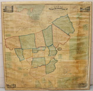
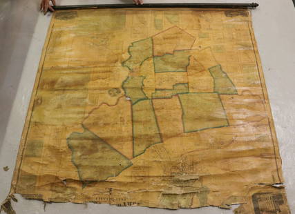
Sold2022MAP OF NORTHAMPTON COUNTY, PA 1860LINEN BACKED MAP MOUNTED ON BACKBOARD UNDER PLEXIGLASS (NO FRAMEWORK). SMITH,GALLUP & CO. PUBLISHERS, PHILADELPHIA, 1860. MEASURES 60" X 58". Terms & Conditions: Pick-up for this Auction will be WedneSee Sold Price
Sold2023An 1860 Map, Counties of New York, New Hampshire, Etc...Hand colored lithograph, by Samuel Augustus Mitchell (1790-1868). :County Map of the States of New York, New Hampshire, Vermont, Massachusetts, Rhode Island and Connecticut". Dimensions:15 1/2" x 23 1See Sold Price
Sold20231877 Mitchell Map of Utah and Nevada [verso] Arizona and New Mexico -- County Map of of Utah andTitle: 1877 Mitchell Map of Utah and Nevada [verso] Arizona and New Mexico -- County Map of of Utah and Nevada [verso] County Map Arizona and New Mexico Cartographer: S Mitchell Year / Place: 1877 PhiSee Sold Price
Sold20231890s Map of Vermont and New Hampshire -- County Map of Vermont and New HampshireTitle: 1890s Map of Vermont and New Hampshire -- County Map of Vermont and New Hampshire Cartographer: Anonymous Year / Place: 1890 ca. Map Dimension (in.): 21.6 X 14.8 in. This is an outstanding doubSee Sold Price
Sold2022MAP OF NORTHAMPTON COUNTY, PA 1860LINEN BACKED MAP. SMITH, GALLUP & CO. PUBLISHERS, PHILADELPHIA, 1860. MEASURES 56" X 57" Terms & Conditions: Pick-up for this Auction will be Wednesday August 3rd and Thursday August 4th from 9:00am tSee Sold Price
Sold20201862 Colton Map of the United States -- Colton's NewTitle/Content of Map: 1862 Colton Map of the United States -- Colton's New Railroad & County Map of the United States the Canadas &c. Cartographer: J Colton Year/Place: 1862, New York Size: 33.1 X 39See Sold Price
Sold2021Gray, Ormando. Gray's New Map of Richmond HenricoGray, Ormando. Gray's New Map of Richmond Henrico County, Virginiacirca 1878, steel engraving with color, presented in a mid-20th century black wooden frame with gilt liner. This detailed map show theSee Sold Price
Sold2019Early Roll-Up New York MapEarly roll-up New York map, "SCARBOROUGH'S / NEW / RAILROAD, POST OFFICE, TOWNSHIP / AND COUNTY MAP OF / NEW YORK". Imperfections. 48" x 41"See Sold Price
Sold2022Scarce early Cram RR map of New YorkExceedingly scarce New York state map from the last Cram atlas to feature hand colored maps. “New Railroad and County Map of New York” from the very scarce 1882 Cram’s Unrivaled FamSee Sold Price
Sold2017Beers: Antique Map of Mid Atlantic Midwest US, 1875Title: 1875 Warner Beers Map of Mid Atlantic and Midwest United States -- County Map of New York, New Jersey, Pennsylvinia, Ohio, Deleware, Maryland, Virginia, West Virginia Cartographer: Warner BeersSee Sold Price
Sold2017Bowen: Map of Brasil Divided into Captainships, 1747Map: A New & Accurate Map of Brasil. Divided into its Captainships Cartographer: Bowen Place & Date: London / 1747 Size: 16 3/4" x 13 5/8" Bowen's wonderfully detailed map of Brazil, from his A CompleSee Sold Price
Featured5 days LeftJasper521878 Mitchell Map of Virginia and West Virginia [verso] New Jersey, Maryland and Delaware -- County$45
7 days LeftForum AuctionsLondon.- Langley (Edward, & Belch, William) Langley and Belch's New Map of London, engraved map,£600
7 days LeftForum AuctionsIndia.- Laurie & Whittle (publishers) A New Map of the Jaghir Lands, on the Coast of Coromandel, The£75
394 Lots AwayPotter & Potter Auctions[PICTORIAL MAPS – TRAVEL]. Three Pictorial Maps. 1940s/50s....$150
Featured5 days LeftJasper52Johnson's New Military Map of the United States Showing the Forts, Military Posts &C. With Enlarged$65


![Map of the US, Colton, 1874 [179353]: The New County map of the United States of America,[x=#8221/] drawn, engraved and printed by G. W. and C. B. Colton & Co., New York 1874. Very large multicolor map, linen back in original Colton bindi](https://p1.liveauctioneers.com/2699/324080/174413237_1_x.jpg?height=310&quality=70&version=1711759488)


![1877 Mitchell Map of Utah and Nevada [verso] Arizona and New Mexico -- County Map of of Utah and: Title: 1877 Mitchell Map of Utah and Nevada [verso] Arizona and New Mexico -- County Map of of Utah and Nevada [verso] County Map Arizona and New Mexico Cartographer: S Mitchell Year / Place: 1877 Phi](https://p1.liveauctioneers.com/5584/293457/155766077_1_x.jpg?height=310&quality=70&version=1687903812)


![1878 Mitchell Map of Virginia and West Virginia [verso] New Jersey, Maryland and Delaware -- County (1 of 2)](https://p1.liveauctioneers.com/5584/329422/177662152_1_x.jpg?height=282&quality=70&version=1715717898)


![[PICTORIAL MAPS – TRAVEL]. Three Pictorial Maps. 1940s/50s.... (1 of 4)](https://p1.liveauctioneers.com/928/325952/175495561_1_x.jpg?height=282&quality=70&version=1712935174)


