Sold20232 Topographical Maps of MASSACHUSETTS2 topographical maps of Massachusetts. 1 marked untied states, East coast, Rhode Island, Massachusetts. Narragansett Bay. Other marked Marthas Vineyard- Eastern Part. Largest map is approximately 47 xSee Sold Price
Sold2022[MAPS & ATLASES]. COLTON, J.H. (1800-1893). Colton's New Topographical Map of The States Of[MAPS & ATLASES]. COLTON, J.H. (1800-1893). Colton's New Topographical Map of The States Of Virginia, Maryland and Delaware, Showing Also Eastern Tennessee & Parts Of Other Adjoining States. New York:See Sold Price
Sold20201873 Lloyd Map of Parts of Eastern and Midwestern US --Title/Content of Map: 1873 Lloyd Map of Parts of Eastern and Midwestern US -- County Map of New York, New Jersey, Pennsylvania, Ohio, Deleware, Maryland, Virginia, West Virginia, Province of Ontario CSee Sold Price
Sold2022Scarce Texas map (eastern part) from Asher & Adams,County map of Eastern Texas extends from Louisiana west to beyond San Antonio and features the railroad system of that time. Features numerous railroads still in their infancy, along with proposed futSee Sold Price
Sold2016George Cram: Map of Eastern Part of Quebec, 1891Map: Eastern Part of Quebec Maker: George Cram Date: 1891 Size: 13.5 x 21.75 inches For "The Home Knowledge Atlas" George F. Cram (1842-1928) served in the U.S. Army during the American Civil War. AftSee Sold Price
Sold2016Vintage Topographical Composition Map of The CaliforniaVintage Topographical Composition Map of The California Shasta Region, contained in wooden shadow box display case, by Dr. J.M. Flint and D.H. McLaughlin {Dimensions 19 1/2 x 19 1/2 x 6 inches} [LosseSee Sold Price
Sold2020IRAN IRAQ The Eastern part of the Ancient PersianTITLE/CONTENT OF MAP: 'THE EASTERN PART OF THE ANCIENT PERSIAN EMPIRE' The top image on the right hand side shows the entire map. To view a close up of the map showing the level of printed detail, pleSee Sold Price
Sold20201889 Map of Eastern TexasAuthor: Cram Title: 1889 Map of Eastern Texas Medium: Ink on Paper Dimensions: 14.5"X22" Map of Eastern part of Texas dated 1889. Engraved and published by George Cram in Chicago. Double folio map. VeSee Sold Price
Sold2017Antique Britannica War/Battle Map of Pennsylvania, 1903Title/Content of Map: 'Pennsylvania, Eastern part; Inset map of Philadelphia and Vicinity' The sites of important battles and their dates are marked on this map for the following conflicts: American RSee Sold Price
Sold20231817 Hall Map of Persia to Kazakhstan -- Map of the Eastern Part of Persia with Afghanistan,Title: 1817 Hall Map of Persia to Kazakhstan -- Map of the Eastern Part of Persia with Afghanistan, Bactriana, Trans-Oxiana &c Cartographer: S Hall Year / Place: 1817, London Map Dimension (in.): 20x1See Sold Price
Sold2016Bowen map of North Africa 1747Heading: (Map) Author: Bowen, Emanuel Title: A New & Accurate Map of the Western Parts of Barbary [on sheet with] A New & Accurate Map of the Eastern Parts of Barbary Place Published: London PublisherSee Sold Price
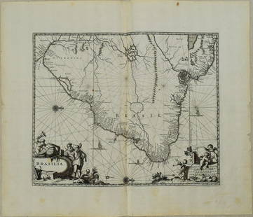
Sold20231671 Ogilby Map of Brazil -- BrasiliaTitle: 1671 Ogilby Map of Brazil -- Brasilia Cartographer: J Ogilby Year / Place: 1671, London Map Dimension (in.): 11.3 X 13.8 in. This is an excellent map of the eastern part of Brazil. There is anSee Sold Price
Sold2022La Polonia divisa ne' suoi Palatinati…. Poland Lithuania &c. ZATTA 1783 mapTITLE/CONTENT OF MAP: 'La Polonia divisa ne' suoi Palatinati tratta dall' Atlante Polacco del Sig. Rizzi Zanoni' "Poland divided into its Palatinates or Voivodeships". The map covers the eastern partSee Sold Price
Sold2016MAP OF NEW YORK, THOMAS KITCHIN, 1756A MAP OF THE EASTERN PART OF THE PROVINCE OF NEW YORK, WITH PART OF NEW JERSEY, showing Pennsylvania, New York state, Long Island, Connecticut and New Hampshire, with Lake OntarioSee Sold Price
Sold2018Sanson/Covens & Mortier: Eastern Holy Land, 1730The later Covens & Mortier edition of Sanson's map of the eastern part of the land of Canaan "now Palestine," derived from von Adrichom's Holy Land map (Situs Terrae Promissionis). Oriented with the wSee Sold Price
Sold2020WEST CANADA'. Southern Ontario. Shows'Indian territory'TITLE/CONTENT OF MAP: 'West Canada' The map shows the eastern part of modern Ontario, divided into districts/counties. Part of the map is shown as "Indian territory", with "Indian traders" marked. VigSee Sold Price
Sold2018Tallis/Rapkin: Antique Map of West Canada, 1849TITLE/CONTENT OF MAP: 'West Canada' The map shows the eastern part of modern Ontario, divided into districts/counties. Part of the map is shown as "Indian territory", with "Indian traders" marked. VigSee Sold Price
Sold2019WEST CANADA. Southern Ontario. Shows 'Indian territory'TITLE/CONTENT OF MAP: 'West Canada' The map shows the eastern part of modern Ontario, divided into districts/counties. Part of the map is shown as "Indian territory", with "Indian traders" marked. VigSee Sold Price
Sold2019WEST CANADA'. Southern Ontario. Shows'Indian territory'TITLE/CONTENT OF MAP: 'West Canada' The map shows the eastern part of modern Ontario, divided into districts/counties. Part of the map is shown as "Indian territory", with "Indian traders" marked. VigSee Sold Price
Sold2023[ANTIQUE MAP] PARTIE DU NORD DE L'AMERIQUE SEPTENTRIONALE. C.1770s[ANTIQUE MAP] PARTIE DU NORD DE L'AMERIQUE SEPTENTRIONALE. Pour Servir a L'historie Philisophique et Politique... By Rigobert Bonne (1727-1795) Map of the eastern part of North America shows the BritiSee Sold Price
Sold2015Fisk & Russell Scarce Civil War Pocket MapThis circa 1862 hand colored folded pocket map was printed by Fisk & Russell, N.Y., no date or title but shows most of the U.S. and southern Canada with small inset map of ‘Eastern Part of MassaSee Sold Price
Sold2022J. H. Colton’s Topographical Map of Louisiana, Mississippi and Alabama. & partsTitle: J. H. Coltonâ€â„¢s Topographical Map of Louisiana, Mississippi and Alabama. & parts of Adjoining States. Publisher: Joseph Hutchins Colton Height: 19 Width: 31 Rare Colton large forSee Sold Price
Sold2016101 MapsVarious Ages, Conozca Sus Raices, 20th Century Map of the Indigenous Peoples of Mexico and Centro America,1995, 24" x 19", folds; 35 Topographical Map of the Mineral Districts of California, 1853, copSee Sold Price
Sold20241749 MAP CARTE DE LA TARTARIE ORIENTALE RUSSIA & CHINA antique EASTERN TARTARYMAP CARTE DE LA TARTARIE ORIENTALE Paris: c. 1749. A map detailing the Asian part of Russia (Eastern Tartary) and China (Manchuria) From "l'Histoire Generale des Voyages" By Jacques Bellin Overall sizSee Sold Price
Jun 23Schilb Antiquarian Rare Books1877 Geology Geography Surveys 1ed Nevada Wyoming Utah George Wheeler US West 2v$1(1 bid)
4 days LeftJasper521738 RUSSIA SIBERIA & GREAT TARTARY Description illustrated ANTIQUE in ENGLISH$950
4 days LeftJasper521872 Asher and Adams Map of Maine and Parts of Quebec, Vermont and New Hampshire -- Asher & Adams$30
Jun 23Schilb Antiquarian Rare Books1855 San Francisco 1st ed California Gold Rush Illustrated MAPS Soule Indians$13(4 bids)
6 hrs LeftTrillium Antique Prints & Rare BooksSanson - 4 Maps of Europe (Germany, Spain & Portugal, Hungary, & Poland)$75
6 hrs LeftTrillium Antique Prints & Rare BooksSanson - 3 Maps of South America (Chili, Peru, Paraguay)$75
6 hrs LeftTrillium Antique Prints & Rare BooksSanson - 5 Maps of Africa (Egypt, Barca, Tunis & Tripoli, Morocco, & Barbary & Alger)$75
Jun 22Trillium Antique Prints & Rare BooksSanson - Map of the Antilles Islands or West Indies with part of Florida$75
Jun 23Schilb Antiquarian Rare Books1848 Emory Military Reconnaissance 1ed California MAP Indians Texas New Mexico$4(4 bids)


![[MAPS & ATLASES]. COLTON, J.H. (1800-1893). Colton's New Topographical Map of The States Of: [MAPS & ATLASES]. COLTON, J.H. (1800-1893). Colton's New Topographical Map of The States Of Virginia, Maryland and Delaware, Showing Also Eastern Tennessee & Parts Of Other Adjoining States. New York:](https://p1.liveauctioneers.com/197/265299/138516337_1_x.jpg?height=310&quality=70&version=1666051328)


![Bowen map of North Africa 1747: Heading: (Map) Author: Bowen, Emanuel Title: A New & Accurate Map of the Western Parts of Barbary [on sheet with] A New & Accurate Map of the Eastern Parts of Barbary Place Published: London Publisher](https://p1.liveauctioneers.com/642/86438/44449747_1_x.jpg?height=310&quality=70&version=1458591928)


![[ANTIQUE MAP] PARTIE DU NORD DE L'AMERIQUE SEPTENTRIONALE. C.1770s: [ANTIQUE MAP] PARTIE DU NORD DE L'AMERIQUE SEPTENTRIONALE. Pour Servir a L'historie Philisophique et Politique... By Rigobert Bonne (1727-1795) Map of the eastern part of North America shows the Briti](https://p1.liveauctioneers.com/8321/286473/155024526_1_x.jpg?height=310&quality=70&version=1686787412)


