Sold2022VICTORIAN FOLIO STANDLate 19th c. Ebonized Floor Stand, for prints, documents and maps, having hinged wings, turned legs, set on a trestle form base with central stretcher, 42 1/4" high, 28 3/4" wide. One side missing winSee Sold Price
Sold2017Jaillot: Antique Map of North America, 1696Map: 1696 Jaillot Map of North America (California as an Island) -- Amerique Septentrionale Divisee en ses Principales Parties Date Printed: 1696 Amsterdam Cartographer: H. Jaillot Size: 19.3 x 23 in.See Sold Price
Sold20243 Maps1.) Lewis Samuel, A Map of Part of the N. W. Territory of the United States: Compiled from Actual Surveys & the beft Information; 2.) The State of Ohio with Part of Upper Canada; 3.) JSee Sold Price
Sold2019CATLIN, George (1796-1872). Letters and Notes on theCATLIN, George (1796-1872). Letters and Notes on the Manners, Customs, and Condition of the North American Indians. London: Published by the Author, 1841. 2 volumes, 8vo. 3 maps (one folding) and 176See Sold Price
Sold2024ANTIQUE TURCICUM IPERIUM (TURKISH EMPIRE) MAPCartouche showing the Turkish Sultan on his throne and allegorical figures at either side brandishing weapons, with smaller cartouche at right h. 16-1/2 w. 21 in. (sight) overall: 23-1/4 x 27-1/4 in.See Sold Price
Sold2020Tolkien, J. R. R.139. Tolkien, J. R. R..The Lord of the Rings. 3 folding maps. 3 volumes. 8vo, publisher's gilt-lettered red cloth, top-edges dyed red; spines faded, tips rubbed, Henry Bosley Woolf bookplates. London,See Sold Price
Sold2018ACUÑA, Cristóbal de (1597-1676?). Voyages andACUÑA, Cristóbal de (1597-1676?). Voyages and Discoveries in South-America. London: for S. Buckley, 1698. 8vo (190 x 111 mm). 2 folding engraved maps; 3 title-pages. (Pale spotting.) 19th-century taSee Sold Price
Sold2022World.- Ellis (William) Polynesian Researches ... in the Society and Sandwich Islands, 4 vol., 1853;NO RESERVE World.- Ellis (William) Polynesian Researches ... in the Society and Sandwich Islands, 4 vol., additional engraved titles, 7 plates, 3 folding maps, scattered spotting, cracked hinges, origSee Sold Price
Sold2022ARROWSMITH, AARON; and SAMUEL LEWIS. A New and Elegant General Atlas.ARROWSMITH, AARON; and SAMUEL LEWIS. A New and Elegant General Atlas. Letterpress title, contents list, and 63 engraved maps (3 folding). 4to, 11x9 inches, original speckled calf backed marbled boardsSee Sold Price
Sold2022(BRITISH EMPIRE.) George Philip & Son, Ltd.; and The London Geographical Institute. Navy League Map(BRITISH EMPIRE.) George Philip & Son, Ltd.; and The London Geographical Institute. Navy League Map of the British Empire. Oversize chromolithograph map of the world delineating early 20th-century BriSee Sold Price
Sold2016Speed map of Turkish Empire 1626Heading: Author: Speed, John Title: The Turkish Empire. Newly Augmented by Iohn Speed 1626 Place Published: London Publisher:G. Humble Date Published: 1626 Description: CopSee Sold Price
Sold2022Map of San Francisco Tidelands for sale, 1869Heading: -1869 Author: Allardt, Geo. F., Surveyor Title: Map No. 3 of Salt Marsh and Tide Lands Situate in the City & County of San Francisco. To be sold at Public Auction, by order of the Boards of TSee Sold Price
Sold20211747 1ed JEWS Assyrian Empire Babylon MAPS Phrygians1747 1ed JEWS Assyrian Empire Babylon MAPS Phrygians Hebrews Judaica The “Universal History” is a mid-18th-century history of the world. Written by numerous authors and contributors, this enormousSee Sold Price
Sold2023Jacob & Co WatchJacob & Co Five Time Zone Stainless Steel Bracelet Watch, Pave Set Diamond World Map Dial with Four Subsidiary Dials for Separate Time Zones. #S7091. Swiss quartz movement. Case measures 48mm. BraceleSee Sold Price
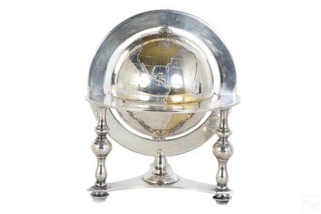
Sold2023Bulgari Sterling Silver & Vermeil Table Globe 805gA Bulgari Italian sterling silver table globe sculpture. Classical style design with spinning world map globe set within a round tri legged ring stand. Map continents finished in gold vermeil, and surSee Sold Price
Sold2023Jules Verne, Nord contre Sud, French Edition Au Globe DoreOutstanding volume from Hetzel Globe Dore French edition of the Voyages Extraordinaires by Jules Verne. It includes the novel Nord contre Sud with 85 illustrations by Bennet and one map.Type 3, EngelSee Sold Price
Sold2022VARIOUS ARTISTS. [ILLUSTRATED MAPS]. Group of 3 posters. 1930s-1940s. Sizes vary.VARIOUS ARTISTS [ILLUSTRATED MAPS]. Group of 3 posters. 1930s-1940s. Sizes vary. Condition varies, generally A- / A. Group includes: A Map of Western Long Island (1939), by Rolf Klep; Michigan / UpperSee Sold Price
Sold2023MITCHELL'S NEW MAP of TEXAS, OREGON & CALIFORNIA1846 Philadelphia, S. Augustus Mitchell. hardcover leather bound. 5 1/4 x 3 1/4 inches. Map unfolded 22 x 20 1/2 inches and presented in a custom frame 23 1/2 x 22 inches (overall)See Sold Price
Sold2021Rare set H.C. Tunison Wall MapsHeading: Author: Tunison, Henry Cuthbert Title: Tunison’s Twentieth Century Series of School Maps Place Published: Jacksonville, IL Publisher:H.C. Tunison, Publisher Date Published: c.1905See Sold Price
Sold2024Tasso Italian Map the United States 1832TASSO, G. (19th Century). Stati-Uniti dell' America Settentrionale dalle Piu Recenti Mappe... Engraved map with original hand color. Venice, 1832. 15 1/4" x 19 3/4" sheet. Scarce map from an Italian eSee Sold Price
Sold2023Map of the British Empire in AmericaPublication Date: 1733 Title: Map of the British Empire in America Cartographer: Henry Popple Publisher: Covens & Mortier Height: 23 Width: 20.5 with the French, Spanish and the Dutch Settlements adjaSee Sold Price
Sold2022MITCHELL, SAMUEL AUGUSTUS. A New Universal Atlas Containing Maps of the Various Empires, Kingdoms,MITCHELL, SAMUEL AUGUSTUS. A New Universal Atlas Containing Maps of the Various Empires, Kingdoms, States and Republics of the World; With a Special Map of Each of the United States, Plans of Cities,See Sold Price
Sold20243 Antique Helvetian Engraved Maps, 17th/18th CProperty from the Estate of a Swiss UBS Executive, Zurich and Hilton Head Island, SC Description: 3 Antique Helvetian Engraved and Hand-Colored Maps, 17th/18th C, circa 1683 - 1715, depicting portSee Sold Price
Sold2022Popple, Henry,(Britain, 16?? - 1743) A Map of The British Empire in America with French, Spanish and(d. 1743) Printed In Amsterdam For L Covens And C. Mortier c.1755, Sight View 19" x 18-1/2", Overall 21" x 26" "Carte Particuliere de l'Amerique Septentrionale."See Sold Price
BonhamsGIBBON (EDWARD) The History of the Decline and Fall of the Roman Empire, 6 vol., FIRST EDITION o...£700
BonhamsPALLAS (PETER SIMON) Travels Through the Southern Provinces of The Russian Empire in the years 1...£10
4 days LeftSchilb Antiquarian Rare Books1897 History of British Empire England Scotland Canada James II MAPS India 6v$110(5 bids)
6 days LeftPiasaJoseph Cornell (Nyack, 1903 - New York, 1972) Lunar Set (Soap Bubble Set, Lunar variant), circa 1950€200,000
3 hrs LeftForum AuctionsTolkien (J.R.R.) The Lord of the Rings, 3 vol., first edition, 1954-5.£12,000
3 days LeftGold Coast Auctioneers17th-19th c. French Wall Art Collection Map City Sea Scapes Scenes etc.$50
3 hrs LeftForum Auctionsd'Anville (Jean Baptiste Bourguignon) [Untitled Composite Atlas with 102 map sheets], [probably£2,000
Jun 15Crescent City Auction GalleryPair of New Orleans Sanborn Fire Insurance Mock-Up Skeleton Maps of the French Quarter, 1910-1911,$250
6 days LeftJasper52Title/Content of Map: Puerto Rico: Port of Guánica by Ferrer Date Printed: 1818$55
BonhamsTOLKIEN (J.R.R.) The Lord of the Rings, 3 vol., FIRST EDITION, FIRST IMPESSIONS, AUTHOR'S PRESE...£8,000
5 days LeftMark Louis Weseloh Estate LiquidationsSix - 17th c. Maps of Europe, Asia, England, Germany x2, Crete, Greece.8 1/4" x 6 5/8".$300
BonhamsSPEED (JOHN) AND WILLEM BLAEU Pictorial title-pages to Speed's 'Theatre of the Empire of Great B...£10


![VARIOUS ARTISTS. [ILLUSTRATED MAPS]. Group of 3 posters. 1930s-1940s. Sizes vary.: VARIOUS ARTISTS [ILLUSTRATED MAPS]. Group of 3 posters. 1930s-1940s. Sizes vary. Condition varies, generally A- / A. Group includes: A Map of Western Long Island (1939), by Rolf Klep; Michigan / Upper](https://p1.liveauctioneers.com/199/255737/132982810_1_x.jpg?height=310&quality=70&version=1658424802)


![d'Anville (Jean Baptiste Bourguignon) [Untitled Composite Atlas with 102 map sheets], [probably (1 of 3)](https://p1.liveauctioneers.com/5458/329231/177514974_1_x.jpg?height=282&quality=70&version=1715269091)


![[MAP]. ORTELIUS, Abraham. Turcici Imperii Descriptio.1592. (1 of 2)](https://p1.liveauctioneers.com/197/329395/177650538_1_x.jpg?height=282&quality=70&version=1715364962)


