Sold20171837 PIRATES & Piracy Barbary States EGYPT Carthage1837 PIRATES & Piracy Barbary States EGYPT Carthage Africa Moors Morocco Bishop Michael Russell was a 19th-century historian who was well-versed in a variety of subjects, including Biblical and Holy LSee Sold Price
Sold20201660 BarbariaThis is an authentic antique map of the northern coast of Africa by Joan Blaeu. The map was published out of Amsterdam circa 1660, and features French text on the verso. This lovely, decorative map foSee Sold Price
Sold2021Barbaria, 1660By: Joan BlaeuDate: 1660 (circa) AmsterdamDimensions: 19 x 22.25 inches (48.25 x 56.5 cm)This is an authentic antique map of the northern coast of Africa by Joan Blaeu. The map was published out of AmSee Sold Price
2022Blaeu, Johannes (Netherlands, 1596-1673) "The New World Map" Double Hemisphere World Map C. 1664Nova et Accuratissima Totius Terrarum Orbis Tabula Translated "The New World Map", Hand Colored w/ Elaborately Decorated Spandrels.   Sight View 16" x 21-1/2", Overall View 21" x 25-1/2"See Sold Price
Sold2016Africa: Barbary Coast.Maker: Jansson, Jan. Origin: Amsterdam, 1657. Medium: Original engraving hand-colored at publication. Sheet size: 18 1/2 x 23 7/8 in No Reserve: This lot starts at $1 and has no reserve as a courtesySee Sold Price
Sold2023NORTH AFRICA BARBARY. Tripoli Libya Egypt coast Alexandria Tobruk. SDUK 1874 mapTITLE/CONTENT OF MAP: 'NORTH AFRICA OR BARBARY, V., PARTS OF TRIPOLI AND EGYPT' DATE PRINTED: 1874 IMAGE SIZE: Approx 34.0 x 42.5cm, 13.25 x 16.75 inches (Large) TYPE: Antique steel engraved map withSee Sold Price
Sold2019Attributed to Johannes Blaeu (1650-1712) Dutch.Attributed to Johannes Blaeu (1650-1712) Dutch. "Tvrcicvm Imperivm", Map, 16.5" x 21".See Sold Price
Sold2015[Map of Russia]. Johannes Blaeu, cartographer. R[Map of Russia]. Johannes Blaeu, cartographer. Russiae, Vulgo Moscovia, Pars AustraSee Sold Price
Sold2022Africa.- Jansson (Johannes) Nigritarum Regnum, [c. 1665]; and 2 others similar, 17th century (3)Africa.- Jansson (Johannes) Nigritarum Regnum, map of West Africa, engraved map with hand-colouring, sheet 530 x 615 mm (20 3/4 x 24 1/4 in), handling creases, some surface dirt and marginal damp-staiSee Sold Price
Sold2020Johannes Blaeu (1596-1673) MapJohannes Blaeu (1596-1673), "Yucatan Conventus luridici Hispaniae Novae Pars Occidentalus, et Guatimala Conventus luridicus", Amsterdam, c. 1662, hand-colored engraved map, 16 1/2 in. x 20 3/4 in., frSee Sold Price
Sold2023"Pecheli, sive Peking, Imperii Sinarum Provincia Prima" by Johannes Blaeu c.1655"Pecheli, sive Peking, Imperii Sinarum Provincia Prima" was created by Johannes Blaeu in approx. 1655. It depicts the Chinese province of Pecheli, also known as Hebei, with the city of Beijing (then kSee Sold Price
Sold20221818 Arab PIRATES Africa Robbins Journal Commerce Shipwreck James Riley Arabia1818 Arab PIRATES Africa Robbins Journal Commerce Shipwreck James Riley Arabia Archibald Robbinss account of the wreck of the Commerce, the American merchant ship, was one of the best accounts of theSee Sold Price
Sold20211840 SDUK Map of Morocco -- Northern Africa or BarbaryTitle: 1840 SDUK Map of Morocco -- Northern Africa or Barbary I Marocco Cartographer: SDUK Year / Place: 1840, London Map Dimension (in.): 12.6 x 15.4 in This is very nice and superbly detailed map ofSee Sold Price
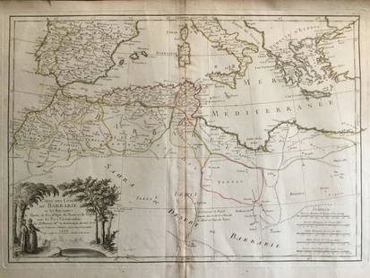
Sold20211787 Bonne Map of Barbary AfricaCarte De La Partie Septentrionale D'Afrique, ou de la Barbarie…, by Rigobert Bonne, published in Paris in 1787. Folding map, Very Good. Measures 15.5 x 10". Reserve: $20.00 Shipping: Domestic: Flat-See Sold Price
Sold2022ENGRAVINGS, Hven, Sweden, BlaeuBlaeu's Engravings of Tycho Brahe's Observatory. Hven, Sweden, Astronomy. Johannes Blaeu, [Lot of 2] Orthographia Praecipuae Domus Arcis Uraniburgi in Insula Prthmi Danici, Venusia... [and] IchnographSee Sold Price
Sold2023MAP, China, BlaeuCentral China, Henan. Johannes Blaeu, Honan, Imperii Sinarum Provincia Quinta, from Novus Atlas Sinensis, 1655 (published). Hand Color. This map of the Henan province is centered on the Yellow River,See Sold Price
Sold2019Africa.- De L'Isle (Guillaume) Carte de la Barbarie deAfrica.- De L'Isle (Guillaume) Carte de la Barbarie de la Nigritie et de la Guinée, map of western Africa from Barbary, Nigeria, and Guinea to below the equator, with numerous tent encampments deSee Sold Price
Sold2019SDUK: North Africa in 5 sheetsMap Title: North Africa or Barbary I – V Cartographer: Baldwin & Cradock, Society for the Diffusion of Useful Knowledge Place/Date: London / 1836/1852 Size: 15 1/4" x 12 1/2" Condition: b&w; overallSee Sold Price
Sold2021French Hollowcast ArabsFour marching fixed arms, based on the Britains movable arm figure. Also 2 Barbary Coast pirates with pistols. 6 pieces. Condition very good. Unboxed.See Sold Price
Sold20211539 ASIA AFRICA EUROPE DESCRIPTION by JOHANNES BOHMJohannes Bohm Omnium gentium mores, leges et ritus, ex multis clarissimis rerum scriptoribus, Ã Ioanne Boemo Aubano Teutonico nuper collecti, & nouissime recogniti. Tribus libris absolutum opus, ApSee Sold Price
Sold20241837. Map of Barbary Coast. Northwest Africa. Morocco, Algeria, Libya and Tunisia. By A. PerrotTitle: 1837. Map of Barbary Coast. Northwest Africa. Morocco, Algeria, Libya and Tunisia. By A. Perrot Date/Period: 1837 Materials: Hand-colored steel engraving Size: 7 x 10 3/4” This is a map oSee Sold Price
Sold2020Barbary coat. North west Africa. Morocco, Tunisia,Title: Barbary coat. North west Africa. Morocco, Tunisia, Algeria and Libya.. Date/Period: 1762 - 1771 Materials: Copperplate engraved Size: 20”x 14 1/2”. Barbary coast, shows North African countrSee Sold Price
Sold20181714 Moll Map of North Africa -- The East Part ofTitle/Content of Map: 1714 Moll Map of North Africa -- The East Part of Barbary Containing Tunis, Tripoli. Barca, Egypt, Nubia, Part of Biledul… Date: 1714 c., London Cartographer: H Moll Size: 6.9See Sold Price
Sold2019Gregoire J. Boonzaier (1909-2005) South Africa ArtistGregoire J. Boonzaier (1909 - 2005) South Africa Artist Oil "Street Of District Six" Gregoire Johannes Boonzaier (1909 - 2005) Gregoire Johannes Boonzaier was active/lived in South Africa. Gregoire BoSee Sold Price
6 days LeftJasper52Barbariae Africanae / Barbaria by Bertius/ Langenes. North Africa Spain 1603 map$85
Jun 08Early American History Auctions1795 Brig BETSY Waybill Captured by Barbary Pirates 1784 Captured Again 1793 with Th. Jefferson Note$375
6 days LeftJasper52NORTH AFRICA. Barbary. Morocco Tunisia Libya Egypt. 'Barbarie'. MALLET 1683 map$20
6 days LeftJasper52NORTH AFRICA OF BABRBARY V Parts of Tripoli & Egypt. Libya Tribes. SDUK 1846 map$15
6 days LeftJasper52NORTH AFRICA OF BABRBARY V Parts of Tripoli & Egypt. Libya Tribes. SDUK 1851 map$20
BonhamsETHIOPIA, SOUTH AFRICA AND MADAGASCAR BLAEU (WILLEM) Aethiopia Superior vel Interior, [Amsterdam...£300
Jun 08Early American History AuctionsCOMMODORE JOHN RODGERS, Naval Board President and Commissioner, Proposals to Charter a Vessel 1817$400
BonhamsBLAEU (WILLEM AND JAN) Toonneel des Aerdrycz, oft Nieuwe Atlas... Tweede Deels, 2 parts in 1 vol...£8,000
6 days LeftJasper52Carte de la Barbarie… l'empire de Maroc… North Africa Morocco. LAPIE 1829 map$40
Featured6 days LeftJasper52La Barbarie de la Nigritie et de la Guinée'. West Africa. DE L’ISLE 1745 map$130
Jun 07Freeman's | Hindman[MAP]. TODESCHI, Pietro. [Nova et Acurata Totius Americae Tabula auct. G.I. Blaeu] America quarta$5,000
3 days LeftSchilb Antiquarian Rare Books1831 PIRATES in America TORTUGA Capt Morgan Buccaneers Drake Cavendish Voyages$88(9 bids)
3 days LeftSchilb Antiquarian Rare Books1569 German Catholic anti Martin Luther Protestant Bible Munich Johannes Via$250(8 bids)


![[Map of Russia]. Johannes Blaeu, cartographer. R: [Map of Russia]. Johannes Blaeu, cartographer. Russiae, Vulgo Moscovia, Pars Austra](https://p1.liveauctioneers.com/906/80657/41935085_1_x.jpg?height=310&quality=70&version=1445283342)
![Africa.- Jansson (Johannes) Nigritarum Regnum, [c. 1665]; and 2 others similar, 17th century (3): Africa.- Jansson (Johannes) Nigritarum Regnum, map of West Africa, engraved map with hand-colouring, sheet 530 x 615 mm (20 3/4 x 24 1/4 in), handling creases, some surface dirt and marginal damp-stai](https://p1.liveauctioneers.com/5458/255060/132669237_1_x.jpg?height=310&quality=70&version=1657897192)


![ENGRAVINGS, Hven, Sweden, Blaeu: Blaeu's Engravings of Tycho Brahe's Observatory. Hven, Sweden, Astronomy. Johannes Blaeu, [Lot of 2] Orthographia Praecipuae Domus Arcis Uraniburgi in Insula Prthmi Danici, Venusia... [and] Ichnograph](https://p1.liveauctioneers.com/6576/263260/137251284_1_x.jpg?height=310&quality=70&version=1664399834)


![AFRICA BLAEU (WILLEM) Africae nova descriptio, [c. 1630 or later] (1 of 2)](https://p1.liveauctioneers.com/1043/316318/178467347_1_x.jpg?height=282&quality=70&version=1716981201)


![[MAP]. TODESCHI, Pietro. [Nova et Acurata Totius Americae Tabula auct. G.I. Blaeu] America quarta (1 of 1)](https://p1.liveauctioneers.com/197/329395/177650542_1_x.jpg?height=282&quality=70&version=1715364962)

