Sold2022North & South Carolina, insert of Charleston , 1862 by Johnson and WardTitle: North & South Carolina, insert of Charleston , 1862 by Johnson and Ward Date/Period: 1862 Materials: Steel plate engraved Size: 19" x 27" 1862 from 'Johnson's New Illustrated Family Atlas' By JSee Sold Price
Sold2022Cuba, Jamaica with inserts of Puerto Rico and Havana, 1862 by Johnson and WardTitle: Cuba, Jamaica with inserts of Puerto Rico and Havana, 1862 by Johnson and Ward Date/Period: 1862 Materials: Steel plate engraved Size: 19" x 14" 1862 from 'Johnson's New Illustrated Family AtlaSee Sold Price
Sold20201862 JOHNSONMAP JOHNSON'S AFRICA 26in x 18in folded, from london news?? 1862 PUBLISHED BY JOHNSON & WARD, frayed heavily on edges and along crease ; material: paper, Shipping cost: $19, Different rate(s) to CalifSee Sold Price
Sold2022New York. 1862. By Johnson and WardTitle: New York. 1862. By Johnson and Ward Date/Period: 1862 Materials: Steel plate engraved Size: 19" x 27" With inserts of eight cities including New York City, Buffalo, and Albany among others. 186See Sold Price
Sold2022Netherlands, Belgium and Luxembourg. 1862 by Johnson and WardTitle: Netherlands, Belgium and Luxembourg. 1862 by Johnson and Ward Date/Period: 1862 Materials: Steel plate engraved. Size: 19" x 14" With inserts of Amsterdam and Brussels. 1862 from 'Johnson's NewSee Sold Price
Sold2015Map of Africa, 1864, Custom FramedOriginal engraving from the World Atlas by Johnson, New York, 1864. Map includes vignettes of Libera, Delta of the Nile, Cape Colony, Cape Verde Islands and St. Helena. Displayed in a wood frame and USee Sold Price
Sold2024Johnson's Africa. Colonies & tribes. Liberia Nile Delta Cape Colony 1866 mapCAPTION PRINTED BELOW PICTURE: 'Johnson's Africa // Liberia, Delta of the Nile, Cape Colony, Cape Verde Islands, and St. Helena' DATE PRINTED: 1866 IMAGE SIZE: Approx 60.5 x 45.5cm, 23.75 x 18 inchesSee Sold Price
Sold2018Johnson's AfricaTitle/Content of Map: Johnson's Africa Date Printed: 1864 Cartographer: JOHNSON, ALVIN JEWETT Size: 23.1x17.25 Inset maps of St. Helena, Cape Verde, Liberia, Delta of the Nile and Cape Colony, no vignSee Sold Price
Sold2018Johnson's AfricaTitle/Content of Map: Johnson's Africa Date Printed: 1864 Cartographer: JOHNSON, ALVIN JEWETT Size: 24x17 Attractive large map with two small inset views and an inset map of the Island of St. Helena iSee Sold Price
Sold2019Scarce 1862 Neb/Dak/Col/Kans - Johnson & WardReserve Reduced! One of the rarest and most desirable states of Johnson's Dakota, Nebraska and Kansas map. In this example Nebraska is drawn with a long panhandle extending from Iowa all the way to FrSee Sold Price
Sold2022Dakota’s and Minnesota. 1862, Johnson and WardTitle: Dakota’s and Minnesota. 1862, Johnson and Ward Date/Period: 1862 Materials: Steel plate engraved Size: 19" x 14" 1862 from 'Johnson's New Illustrated Family Atlas' By Johnson and Ward. PuSee Sold Price
Sold2021Bellin: West Coast of Africa with St. Helena IslandTitle/Content of Map: Bellin: West Coast of Africa with St. Helena Island Date Printed: 1739/1760, Paris Cartographer: Bellin Size: 10 1/4" x 9 1/2" Additional Info: Bellin's map of the west coast ofSee Sold Price
Sold2022Title page. 1862. Johnson and WardTitle: Title page. 1862. Johnson and Ward Date/Period: 1862 Materials: Steel plate engraved. Size: 19" x 14" 1862 from 'Johnson's New Illustrated Family Atlas'. By Johnson and Ward. Published in New YSee Sold Price
Sold20241862 Civil War-era map of Alabama/Georgia, Johnson & WardJohnson’s Georgia and Alabama from the 1862 edition of Johnson’s Family Atlas published during the second year of the war in 1862 by Johnson & Ward. Shows railroads operating at the beginnSee Sold Price
Sold2019Johnson’s North America, Johnson & Ward, 1862Interesting configuration of North America, particularly the United States, Canada and Mexico, just after the outbreak of the Civil War. States roughly follow the 1861 configuration with archaic bordeSee Sold Price
Sold2022North America, 1862 by Johnson and WardTitle: North America, 1862 by Johnson and Ward Date/Period: 1862 Materials: Steel plate engraved Size: 19" x 27" 1862 from 'Johnson's New Illustrated Family Atlas' By Johnson and Ward. Published in NeSee Sold Price
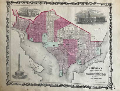
Sold2022Washington D.C. 1862 by Johnson and WardTitle: Washington D.C. 1862 by Johnson and Ward Date/Period: 1862 Materials: Steel plate engraved Size: 19" x 14" 1862 from 'Johnson's New Illustrated Family Atlas' By Johnson and Ward. Published in NSee Sold Price
Sold2022Mexico, 1862 by Johnson and WardTitle: Mexico, 1862 by Johnson and Ward Date/Period: 1862 Materials: Steel plate engraved Size: 19" x 14" 1862 from 'Johnson's New Illustrated Family Atlas' By Johnson and Ward. Published in New York.See Sold Price
Sold2022Maryland and Delaware 1862 by Johnson and WardTitle: Maryland and Delaware 1862 by Johnson and Ward Date/Period: 1862 Materials: Steel plate engraved Size: 19" x 14" 1862 from 'Johnson's New Illustrated Family Atlas' By Johnson and Ward. PublisheSee Sold Price
Sold2022Austrian empire, Hungary, entire Balkans, 1862 by Johnson and WardTitle: Austrian empire, Hungary, entire Balkans, 1862 by Johnson and Ward Date/Period: 1862 Materials: Steel plate engraved. Size: 19" x 27" 1862 from 'Johnson's New Illustrated Family Atlas'. By JohnSee Sold Price
Sold2022Ireland, 1862 by Johnson and WardTitle: Ireland, 1862 by Johnson and Ward Date/Period: 1862 Materials: Steel plate engraved. Size: 19" x 14" 1862 from 'Johnson's New Illustrated Family Atlas'. By Johnson and Ward. Published in New YoSee Sold Price
Sold2022New Jersey, 1862 by Johnson and WardTitle: New Jersey, 1862 by Johnson and Ward Date/Period: 1862 Materials: Steel plate engraved Size: 19" x 14" 1862 from 'Johnson's New Illustrated Family Atlas' By Johnson and Ward. Published in New YSee Sold Price
2022Maine 1862 by Johnson and WardTitle: Maine 1862 by Johnson and Ward Date/Period: 1862 Materials: Steel plate engraved Size: 19" x 27" 1862 from 'Johnson's New Illustrated Family Atlas' By Johnson and Ward. Published in New York. SSee Sold Price
Sold2019Anon 1816 Hand Col Map. Island of St. Helena, Africa"The Island & Forts of St. Helena" Copper Engraved Map Published 1816 by Nuthall, Fisher & Co., Liverpool. Unknown Cartographer/Engraver. Paper Size: 10.5 x 8.5 inch (27 x 22cm) Chip to bottom marginSee Sold Price
5 days LeftMynt Auctions1931 British South Africa Cape of Good Hope Stamp Cover Kimberley to St Helena$310
6 days LeftGalerie Moenius AGRUSSIAN ICON WITH GILDED SILVER OKLAD SHOWING ST. CONSTANTIN AND ST. HELENA WITH ST. ANASTASIA€800
4 days LeftForum AuctionsSt. Helena.- Beatson (Maj.-Gen. Alexander) Tracts Relative to the Island of St. Helena, 1816£400
Jun 08Simpson Galleries, LLC.AN AMERICAN CIVIL WAR ERA ATLAS, "Johnson's New Illustrated Family Atlas of the World with Physical$300
Jun 06Austin Auction Gallery(4) MAYAUEL WARD (B. 1956) & JOE ST. CLAIR (D. 1987) COLORED PAPERWEIGHTS$100
Jun 09Heartland Artifact Auctions Inc9" x 7" Nodena Water Vessel, Johnson COA, found in St. Francis Co., Arkansas$10(1 bid)
6 days LeftGalerie Moenius AGVERY RARE RUSSIAN ICON SHWOING ST. NICHOLAS AND THE GUARDIAN ANGEL WITH SCENES OF THEIR VITA€3,000
5 days LeftFreeman's | Hindman[CIVIL WAR]. JOHNSON, Andrew (1808-1875). Two military commissions stamp signed ("Andrew Johnson")$300
5 days LeftFreeman's | Hindman[CIVIL WAR - GETTYSBURG]. CDV of General John Henry Hobart Ward, KIA at Gettysburg. New York:$200
Jun 08Early American History Auctions1877 JULIA WARD HOWE American Abolitionist + Womans Vote Autograph Letter Signed MOURNING Stationary$350
4 days LeftNY Elizabeth ANTIQUE MAP-ILLUSTRATED FLORAL ILLUSTRATION 1761 NEW DICTIONARY OF TRADE AND COMMERCE R. ROTH$50
5 days LeftFreeman's | Hindman[CIVIL WAR]. Photographer unknown. Tent Wards, Harewood Hospital near Washington, D.C. 1862-1865.$200


![[CANADIAN VERNACULAR] LOT OF 190 PRINTS TOGETHER (1 of 1)](https://p1.liveauctioneers.com/8124/329803/177770641_1_x.jpg?height=282&quality=70&version=1715634941)

![[CIVIL WAR]. JOHNSON, Andrew (1808-1875). Two military commissions stamp signed ("Andrew Johnson") (1 of 1)](https://p1.liveauctioneers.com/197/329785/177758348_1_x.jpg?height=282&quality=70&version=1715625218)

![[CIVIL WAR - GETTYSBURG]. CDV of General John Henry Hobart Ward, KIA at Gettysburg. New York: (1 of 2)](https://p1.liveauctioneers.com/197/329785/177758286_1_x.jpg?height=282&quality=70&version=1715625218)


![[CIVIL WAR]. Photographer unknown. Tent Wards, Harewood Hospital near Washington, D.C. 1862-1865. (1 of 2)](https://p1.liveauctioneers.com/197/329785/177758336_1_x.jpg?height=282&quality=70&version=1715625218)