SoldAgnes Denes (American/Hungarian, b. 1931) Map Projection: The Snail, 1978Agnes Denes (American/Hungarian, b. 1931) Map Projection: The Snail, 1978 lithograph signed, dated, titled and numbered 11/50 in pencil 24 x 30 inches. Property from a Private Art Collection <See Sold Price
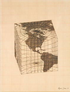
Sold2021Agnes Denes - Study of Distortions; Isometric SystemsLot 3 Agnes Denes Hungarian/American (b. 1931) Study of Distortions; Isometric Systems in Isotropic Space-Map Projections: The Cube (1975) gouache and ink on graph paper and mylar signed lower right sSee Sold Price
Sold2021Agnes DENES: "Probability Pyramid" - LithoEdition 1/40 lithograph titled "Probability Pyramid", by Agnes Dene (Hungarian, b. 1931). [Frame: 31 3/4" H x 43 1/2" W].See Sold Price
Sold2022Agnes Denes [COLUMBINE] Color lithograph and screenprint, framedAgnes Denes (b. 1938) [COLUMBINE] Color lithograph and screenprint, 1980, on wove paper, signed, dated and inscribed Kingdom Series and AP in pencil, with full margins, framed. Sheet 40 7/8 x 28 7/8 iSee Sold Price
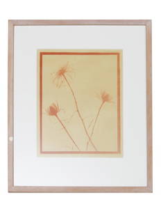
Sold2022VINTAGE AMERICAN MONOTYPE ON PAPER BY AGNES DENESAgnes Denes (Hungarian, American, born 1938) monotype on paper, Transparency of Roses, 1970s. Framed. Titled, dated, described on verso. Dimensions: Frame size: 17 x 14 1/2 in. Picture size: 10 3/4 xSee Sold Price
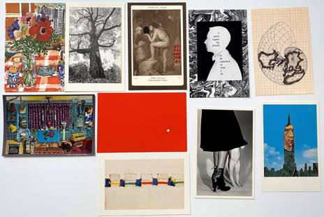
Sold2020Grouping of 10 Photo-Litho PostcardsFeaturing: Chris von Wangenheim, Tom Zetterstrom, Wayne Thiebaud, Massimo Vignelli, Agnes Denes, Nell Blaine, Manuel Casimiro, Tom Prassis, Jonathan Williams, Robert Cuneo Each: 4" x 6"See Sold Price
Sold2021SCOTTISH NEEDLEWORK MAP SAMPLER LATE 18TH/ EARLY 19THoutlined in silk on a linen ground, the place names in black, signed 'Agnes Watson/ Edinburgh' in a cartouche, mounted but unframed (Dimensions: 40cm x 34cm)(40cm x 34cm)Provenance: Property from TornSee Sold Price
Sold2019Strait of Magellan Map[Strait of Magellan Map] , "Fretum Magellannicum", by Theodore De Bry, Frankfurt, 1601, copper engraved, depicting ships, natives, a penguin and a snail, 6 1/2 in. x 11 3/4 in., framed IMPORTANT: AllSee Sold Price
Sold2022John Smith Map of New England, Extremely Rare 2nd StateSMITH, John (1580-1631). New England the most remarqueable parts thus named by the high and mighty Prince Charles, Prince of great Britaine. Observed and described by Captayn John Smith... CopperplateSee Sold Price
2021GREAT NORTHERN’S 2 GREAT TRAINS SYSTEM MAP.Huge dramatic reverse glass advertising Great Northern's two great trains, Empire Builder and Western Star. In script just below Great Northern logo it states "Steamliners twice a day, each way, betweSee Sold Price
Sold2022[STREETER COPY] SEARCY, I. G. Map of Florida constructed principally from authentic documents in the[STREETER COPY] SEARCY, I. G. Map of Florida constructed principally from authentic documents in the Land office at Tallahassee by I. G. Percy. Published by I.G. Searcy Tallahassee & F. Lucas Jr., BalSee Sold Price
Sold2020Gastaldi Map of Africa*** START PRICE IS THE RESERVE *** [Africa]. GASTALDI, Giacomo (1500-1566) & FORLANI, Paolo (fl. 1560-1571). La Descrittione dell'Africa. Engraved Map. Venice: Paolo Forlani, 1562. 19 x 25 1/4 inchesSee Sold Price
Sold2016T-O World Map.- Lucanus (Marcus Annaeus) Pharsalia,Lucanus (Marcus Annaeus) Pharsalia, manuscript on paper, [Northern Italy (possibly Padua), first half of the fifteenth century]. 294 x 217mm., I + 149 + I leaves (including defective leaves and 3 blanSee Sold Price
Sold2024Petrus Plancius, Engraved World MapOrbis Terrarum Typus de Integro Multis in Locis Emendatus. Petrus Plancius (1552-1622). Copper-plate engraving with original hand color in full. Amsterdam, 1594. Some stains, creases, folds. Sight sizSee Sold Price
Sold2015A Fine & Rare Map of New York.Bernard Ratzer "Plan of the City of New York". Signed lower right in the plate "T. Kitchin Sculpt" (Kitchin recorded the cartographer's name as Ratzen (sic) rather than Ratzer). The map backed, rolledSee Sold Price
Sold20201761 MAP OF NORTH AMERICA BY ROCQUE18th century map GENERAL MAP OF NORTH AMERICA 1754-1761 by John Rocque, London by A. Drury, 2 part map, 35.5 x 36 inches, good condition.See Sold Price
Sold2021Haunted Mansion Imagineering Map Blueline Print.(Disneyland, 1969) A large and remarkable WED Imagineering blueline design print of the Haunted Mansion drawn by Imagineer Dan Williams. Dated in the print 04-3-69, the 1/8":1' scale Key Area & LocatiSee Sold Price
Sold2022SOL LEWITT (1928-2007) R706 Map of London with the area between the underground stations at Marb...SOL LEWITT (1928-2007) R706 Map of London with the area between the underground stations at Marble Arch, St. James Park, Leicester Square, Waterloo Station, Pimlico, Sloane Sq., Knightsbridge, BayswatSee Sold Price
Sold2024Keats (John) Lamia, Isabella, The Eve of St. Agnes, and other Poems, first edition, Printed forKeats (John) Lamia, Isabella, The Eve of St. Agnes, and other Poems, first edition, half-title, 4 advertisement leaves at end, beautiful copy in red morocco, gilt, by Riviere, inner gilt dentelles, t.See Sold Price
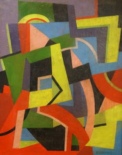
Sold2016AGNES WEINRICH (AMERICAN/ MASSACHUSETTS 1873-1946) OILAGNES WEINRICH (AMERICAN/ MASSACHUSETTS 1873-1946) OIL ON CANVAS, UNTITLED, CUBIST COMPOSITION, SIGNED. 34 X 27"; FRAMED 41 1/2 X 34 1/2"See Sold Price
Sold2022Color map of San Francisco Chinatown 1885Heading: -1885 Author: Title: Official Map of Chinatown in San Francisco Place Published: San Francisco Publisher: Date Published: 1885 Description: Color lithographed map. 21.1See Sold Price
Sold20221592 map of Iceland with monsters, Abraham Ortelius1592 map of Iceland with monsters, Abraham Ortelius from Theatre of the WorldNew photos uploaded on 4/18Plate size: 19.5" x 13.25"See Sold Price
May 29Cedarburg Auction & Appraisals LLCSet of Four Maps Showing All of Spain and Portugal$375(2 bids)
May 29Cedarburg Auction & Appraisals LLCRare 1877 Double sided map of Milwaukee and Wisconsin$40(4 bids)
Jun 07Freeman's | Hindman[MAP]. TODESCHI, Pietro. [Nova et Acurata Totius Americae Tabula auct. G.I. Blaeu] America quarta$5,000
Jun 07Freeman's | Hindman[MAP]. ORTELIUS, Abraham. Americae Sive Novi Orbis, Nova Descriptio. 1573.$1,000(1 bid)
May 30Antiques Online AuctionsVintage Texas 1845 Map Printed in 1986, Compiled by John Davis$60(4 bids)
4 days LeftArarity AuctionsThomson's 1817 Hand Colored Map Comparative Heights of the World's Great Mountains$50


![Agnes DENES: "Probability Pyramid" - Litho: Edition 1/40 lithograph titled "Probability Pyramid", by Agnes Dene (Hungarian, b. 1931). [Frame: 31 3/4" H x 43 1/2" W].](https://p1.liveauctioneers.com/1221/196403/99777990_1_x.jpg?height=310&quality=70&version=1615825772)
![Agnes Denes [COLUMBINE] Color lithograph and screenprint, framed: Agnes Denes (b. 1938) [COLUMBINE] Color lithograph and screenprint, 1980, on wove paper, signed, dated and inscribed Kingdom Series and AP in pencil, with full margins, framed. Sheet 40 7/8 x 28 7/8 i](https://p1.liveauctioneers.com/292/253542/131751272_1_x.jpg?height=310&quality=70&version=1656533559)

![Strait of Magellan Map: [Strait of Magellan Map] , "Fretum Magellannicum", by Theodore De Bry, Frankfurt, 1601, copper engraved, depicting ships, natives, a penguin and a snail, 6 1/2 in. x 11 3/4 in., framed IMPORTANT: All](https://p1.liveauctioneers.com/268/150890/76180328_1_x.jpg?height=310&quality=70&version=1569336980)


![[STREETER COPY] SEARCY, I. G. Map of Florida constructed principally from authentic documents in the: [STREETER COPY] SEARCY, I. G. Map of Florida constructed principally from authentic documents in the Land office at Tallahassee by I. G. Percy. Published by I.G. Searcy Tallahassee & F. Lucas Jr., Bal](https://p1.liveauctioneers.com/292/250642/130213737_1_x.jpg?height=310&quality=70&version=1654271664)
![Gastaldi Map of Africa: *** START PRICE IS THE RESERVE *** [Africa]. GASTALDI, Giacomo (1500-1566) & FORLANI, Paolo (fl. 1560-1571). La Descrittione dell'Africa. Engraved Map. Venice: Paolo Forlani, 1562. 19 x 25 1/4 inches](https://p1.liveauctioneers.com/1968/163248/82424552_1_x.jpg?height=310&quality=70&version=1583340284)
![T-O World Map.- Lucanus (Marcus Annaeus) Pharsalia,: Lucanus (Marcus Annaeus) Pharsalia, manuscript on paper, [Northern Italy (possibly Padua), first half of the fifteenth century]. 294 x 217mm., I + 149 + I leaves (including defective leaves and 3 blan](https://p1.liveauctioneers.com/5458/94966/48431616_1_x.jpg?height=310&quality=70&version=1476369049)


![[MAP]. TODESCHI, Pietro. [Nova et Acurata Totius Americae Tabula auct. G.I. Blaeu] America quarta (1 of 1)](https://p1.liveauctioneers.com/197/329395/177650542_1_x.jpg?height=282&quality=70&version=1715364962)


![[MAP]. ORTELIUS, Abraham. Turcici Imperii Descriptio.1592. (1 of 2)](https://p1.liveauctioneers.com/197/329395/177650538_1_x.jpg?height=282&quality=70&version=1715364962)
![[MAP]. ORTELIUS, Abraham. Americae Sive Novi Orbis, Nova Descriptio. 1573. (1 of 2)](https://p1.liveauctioneers.com/197/329395/177650534_1_x.jpg?height=282&quality=70&version=1715364962)
![[MAPS]. A group of 3 engraved maps, most with hand-coloring. (1 of 4)](https://p1.liveauctioneers.com/197/328642/177014805_1_x.jpg?height=282&quality=70&version=1714760103)


