Sold2021TURKEY IN ASIA, PERSIA, ARABIA & EGYPT MAP 1878Size: 18 X 13 inches approx. Unframed. Printed 1878. Centerfold as issued.See Sold Price
Sold2018Mitchell: Antique Map of Asia [verso] Middle East 1878Title/Content of Map: 1878 Mitchell Map of Asia [verso] Middle East -- Map of Asia Showing its Gt. Political Divisions… [verso] Map of Persia, Arabia, Turkey in Asia, Afghanistan, Beloochistan DateSee Sold Price
20231803 Voyages in TIBET Bhutan Panchen Lama Buddhism Campe ASIA MAP Samuel Turner1803 Voyages in TIBET Bhutan Panchen Lama Buddhism Campe ASIA MAP Samuel Turner Joachim Heinrich Campe was an 18th-century German author known for his travelogues and histories of voyages. One of hisSee Sold Price
Sold2017Currier & Ives: San Francisco Birds Eye View Map, 1878Map: The City of San Francisco Birds Eye View Looking from the Bay South-West Cartographer: Currier & Ives Date: 1878 Size: 11.4 x 17.75 inches This is a rare view of San Francisco of the late 1800s lSee Sold Price
Sold2022Antique Map of Asia - Map of Northern India - Dabhol - Rigobert BonneTitle: Antique Map of Asia - Map of Northern India - Dabhol - Rigobert Bonne Date/Period: 1780 Dimension: 23 cm x 36 cm Material: Paper Additional Information: Antique map of northern India. Covers thSee Sold Price
Sold2017Reichard: Ottoman Empire in Asia Map, 1820Map: Ottoman Empire in Asia Map, "Charte des Osmanischen Reichs in Asien" Cartographer: Reichard Place & Date: Weimar / 1820 Size: 24 3/4" x 19" Condition: light overall age toning; an occasional spotSee Sold Price
Sold20241860 Mitchell Map of Asia -- Map of Asia Showing its Gt. Political Divisions?Title: 1860 Mitchell Map of Asia -- Map of Asia Showing its Gt. Political Divisions? Cartographer: S Mitchell Year / Place: 1860, Philadelphia Map Dimension (in.): 10.5 x 13.5 in. A magnificent map ofSee Sold Price
Sold2021AUSTRO - HUNGARY MAP 1878Size: 18 X 13 inches approx. Unframed. Printed 1878. Centerfold as issued.See Sold Price
Sold20201860 Mitchell Map of Asia -- Map of Asia Showing itsTitle/Content of Map: 1860 Mitchell Map of Asia -- Map of Asia Showing its Gt. Political DivisionsÂ… Cartographer: S Mitchell Year/Place: 1860, Philadelphia Size: 10.5 x 13.5 in. A magnificent mapSee Sold Price
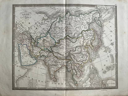
20241839 Asia Map by MoninTitle: 1839 Asia Map by Monin Date/Period: 1839 Materials: Hand colored, engraved Size: 17 1/2 x 12 1/2" This map is an interesting depiction of Asia in 1839 when the continent was still largely unexpSee Sold Price
Sold20181860 Mitchell Map od Asia -- Map of Asia Showing itsTitle/Content of Map: 1860 Mitchell Map od Asia -- Map of Asia Showing its Gt. Political Divisions… Date Printed: 1860, Philadelphia Cartographer: S Mitchell Size: 10.5 x 13.5 in. A magnificent mapSee Sold Price
Sold20211860 Mitchell Map od Asia -- Map of Asia Showing itsTitle: 1860 Mitchell Map od Asia -- Map of Asia Showing its Gt. Political Divisions… Cartographer: S Mitchell Year / Place: 1860, Philadelphia Map Dimension (in.): 10.5 x 13.5 in. A magnificent mapSee Sold Price
Sold2021United States MAP 1878Size: 18 X 13 inches approx. Unframed. Printed 1878. Centerfold as issued.See Sold Price
Sold2021SCOTLAND MAP 1878Size: 18 X 13 inches approx. Unframed. Printed 1878. Centerfold as issued.See Sold Price
Sold2021GERMAN EMPIRE, HOLLAND & BELGIUM MAP 1878Size: 18 X 13 inches approx. Unframed. Printed 1878. Centerfold as issued.See Sold Price
Sold2022North America MAP 1878Size: 18 X 13 inches approx. Unframed. Printed 1878. Centerfold as issued.See Sold Price
Sold2021ITALY, TURKEY IN EUROPE & GREECE MAP 1878Size: 18 X 13 inches approx. Unframed. Printed 1878. Centerfold as issued.See Sold Price
Sold2021IRELAND MAP 1878Size: 18 X 13 inches approx. Unframed. Printed 1878. Centerfold as issued.See Sold Price
Sold20211895 Asia MapAuthor: Cram Title: 1895 Asia Map Medium: Ink on Paper Dimenions: 22"X15" Description: Map of Asia dated 1895. Printed by George Cram for Walker's International Atlas. Published in Chicago and New YorSee Sold Price
Sold20211865 Mitchell Map of Asia -- Map of AsiaTitle: 1865 Mitchell Map of Asia -- Map of Asia Cartographer: S Mitchell Year / Place: 1865, Philadelphia Map Dimension (in.): 8.8 X 10.6 in. This is a handsome Asia map by Mitchell, with color codedSee Sold Price
Sold20231891 Mitchell Map of Asia -- Map of Asia…Title: 1891 Mitchell Map of Asia -- Map of Asia… Cartographer: S Mitchell Year / Place: 1891, Philadelphia Map Dimension (in.): 8.2 X 10.6 in. This is an excellent map of Asia. Inset is PalestinSee Sold Price
Sold20211859 Ancient Asia MapAuthor: Chambers Title: 1859 Ancient Asia Map Medium: Ink on Paper Dimenions: 11.5"X9.5" Description: Map of Ancient Asia Minor dated 1859. It captures the Black Sea region with modern day Turkey andSee Sold Price
Sold2023Lot of 2 Africa, Asia Maps 1808-1809. Size 13 1/2 x 10 1/2 inches lengthLot of 2 Africa, Asia Maps 1808-1809. Size 13 1/2 x 10 1/2 inches length. The map shows Africa way before the infamous expedition by John Hanning Speke to the source of the Nile.See Sold Price
Sold2024ASIA. Map of the Mountain Chains and the River systems of Asia 1881 oldTITLE/CONTENT OF MAP: 'Map of the Mountain Chains and the River systems of Asia' DATE PRINTED: 1881 IMAGE SIZE: Approx 24.0 x 32.0cm, 9.5 x 12.5 inches (Large); Please note that this is a folding map.See Sold Price
7 days LeftJasper521878 Mitchell Map of Georgia and Alabama -- County Map of the States of Georgia and Alabama$50
Jun 13Swann Auction Galleries(ASIA.) John Speed. Asia with the Islands Adjoyning Described, the Atire of the People, & Townes of$900
3 days LeftLeon GalleryVincenzo Maria Coronelli (1650-1718) - Asia Divisa Nelle sue Parti Secondo lo Stato Presente₱220,000


![Mitchell: Antique Map of Asia [verso] Middle East 1878: Title/Content of Map: 1878 Mitchell Map of Asia [verso] Middle East -- Map of Asia Showing its Gt. Political Divisions… [verso] Map of Persia, Arabia, Turkey in Asia, Afghanistan, Beloochistan Date](https://p1.liveauctioneers.com/5584/117349/60339353_1_x.jpg?height=310&quality=70&version=1520390147)


![Maps of Asia & India, c1800's (2) [180164] (1 of 2)](https://p1.liveauctioneers.com/2699/331495/178785787_1_x.jpg?height=282&quality=70&version=1717094933)


