Sold2017Wall map of Marin County 1892Heading: (California - Marin County) Author: Dodge, George M. Title: Official Map of Marin County, California 1892 Compiled from Records and Surveys Place Published: San Francisco Publisher:Schmidt LaSee Sold Price
Sold2022LARGE ARCHITECTS PRINT / MAP / CHART CABINETFantastic very large Architectural draftsman/chart/map/print flat file - George III-Style mahogany with satinwood inlay, inset tooled leather top. 8 Drawer over 4 drawer. from the Audubon Gallery, KinSee Sold Price
Sold2017Jean Gillon (Iasi 1919 - San Paolo 2007) Pair ofJean Gillon (Iasi 1919 - San Paolo 2007) Pair of armchairs model "Captain's chair". Wood Art manufacture, Brasil late 1950s. Bearing original label of manufacturer. Jacaranda wood, plaited rope, leathSee Sold Price
Sold2022ANDERSON, Sherwood (1876–1941). Winesburg, Ohio. New York: ...ANDERSON, Sherwood (1876–1941). Winesburg, Ohio. New York: B.W. Huebsch, 1919. 8vo. Map of Winesburg, Ohio on front pastedown. Original publisher’s yellow cloth, printed paper spine label,See Sold Price
Sold2022Romain de Tirtoff detto Ertè (San PietroburgoRomain de Tirtoff detto Ertè (San Pietroburgo 1892-Parigi 1990) Costumi di moda 5+1 acquarelli f.ti cm.25x37See Sold Price
Sold2022Color map of San Francisco Chinatown 1885Heading: -1885 Author: Title: Official Map of Chinatown in San Francisco Place Published: San Francisco Publisher: Date Published: 1885 Description: Color lithographed map. 21.1See Sold Price
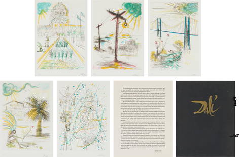
Sold2021Salvador Dalí San Francisco Suite, 1970Salvador Dalí (Spanish, 1904-1989) San Francisco Suite (Michler & Löpsinger 435-439. Field 70-74), 1970 Etchings on BFK Rives paper ed. 88 of 150 22.75 x 15.75 (in) 31.25 x 23.75 x 1.5 (in)See Sold Price
Sold2020Salvador Dali - San Francisco City HallArtist: Salvador Dali Title: City Hall Year: 1970 Dimensions: 26 1/2in. by 19 1/2in. Edition: From the rare limited edition of LXXV Publisher: Jean SchneiderSee Sold Price
Sold2022Faust's Map of San Francisco 1904Heading: -1904 Author: Faust, H.W. Title: Faust's Map of City and County of San Francisco California Place Published: San Francisco Publisher:Published by H.W. Faust Date Published: 1904 <See Sold Price
Sold2021San Antonio Conservation Society 1926 MapVintage 1926 San Antonio Conservation Society historic guide map of San Antonio de Bexar, drawn by Emily Edwards, portrays San Antonio from 1682-1721, unframed 39 x 28"; Provenance: A Schertz, TX EsSee Sold Price
Sold2023Jose Vives-Atsara, "Houses on the Creek - Spain", 1981Jose Vives-Atsara (Spain/San Antonio, Texas, 1919-2004), "Houses on the Creek - Spain", 1981, oil on canvas sight: 9 x 12 in., frame: 13 x 16 in. Provenance: The Estate of Mrs. Burton GrossmSee Sold Price
Sold2023Jose Vives-Atsara, "El Sendero, Texas", 1970Jose Vives-Atsara (Spain/San Antonio, Texas, 1919-2004), "El Sendero, Texas", 1970, oil on canvas sight: 16 x 12 in., frame: 23.5 x 19.5 in. Provenance: A San Antonio, Texas collection OneSee Sold Price
Sold2022Rare map of Chinatown, San Francisco, 1929Heading: -1929 Author: Wong, J.P. Title: Map of San Francisco Chinatown / ????????: ??? / Meiguo Sanfan Shi hua qiao qu: xiang xi tu Place Published: San Francisco Publisher: Date Published:See Sold Price
Sold2024Jose Vives-Atsara, "Houses on the Creek in Spain", 1981Jose Vives-Atsara (Spain / San Antonio, Texas, 1919-2004), "Houses on the Creek in Spain", 1981, oil on canvas, includes typed letter from 1982 on Vives-Atsara's studio letterhead with invSee Sold Price
Sold2023Jose Vives-Atsara, Marsh SceneJose Vives-Atsara (Spanish/San Antonio, Texas, 1919-2004), marsh scene, oil on canvas sight: 16 x 20 in., frame: 21.5 x 25.5 in. One of the most popular and memorable figures in the South Texas artSee Sold Price
Sold2022San Antonio Conservation Society 1926 MapVintage 1926 San Antonio Conservation Society historic guide map of San Antonio de Bexar, drawn by Emily Edwards, portrays San Antonio from 1685-1721, framed, dated 1926 41"h x 30"w Provenance: A SSee Sold Price
Sold20221852 S.F. map with manuscript key to placesHeading: -1852 Author: Quirot & Co. Title: Map of San-Francisco, California. Lith. & Published by Quirot & Co. corner of California & Montgomery Sts. S-Francisco - with added manuscript key Place PublSee Sold Price
Sold202370304: A Marshall Islands Navigation Map Micronesia, 1A Marshall Islands Navigation Map Micronesia, 19th century Constructed of coconut palm leaf midribs and shells. Such maps or charts were for navigating specific atolls and islands in MicrSee Sold Price
Sold2023Mira SCHENDEL (1919-1988) Swiss - Italian - BrazilianMira SCHENDEL (1919 Zurich - 1988 San Paulo) ; Untitled abstract ; 1960s ; oil on canvas / framed ; dimensions 46 x 61,5 cm (18 x 24 1/4 in.) ; frame size 49 x 64 cm (19 1/3 x 25 1/4 in.) ; signed onSee Sold Price
Sold2023SALVADOR DALI, CRISTO DE SAN JUAN DE LA CRUZ 28 cm CERTIFIED.SALVADOR DALI, CRISTO DE SAN JUAN DE LA CRUZ 28 cm CERTIFIED.Sculpture with certificate card.Bronze, Ed. 9 / 10.Signed.Measurements: 28 x 21 cm.Chain 44 cm.Frame: 75 x 60 cm.Illustrated on page 49 ofSee Sold Price
Sold2022[CALIFORNIA]. Photo album of 43 black-and-white photographs...[CALIFORNIA]. Photo album of 43 black-and-white photographs of Central and Northern California views. [San Francisco: Faber Photo, 1887-1892]. Photos (123 x 197 mm) mounted onto card stock leaves (168See Sold Price
Sold2022Real estate in Balboa Park, S.F.Heading: -1911 Author: Punnett, John M. Title: Map of Mission Terrace San Francisco California Place Published: San Francisco Publisher:Baldwin & Howell Date Published: 1911 DescriptionSee Sold Price
Sold2022Ms. map of Potrero district SF 1865Heading: -1865 Author: Title: Map of Potrero Nuevo, San Francisco. May, 1865 Place Published: San Francisco Publisher: Date Published: 1865 Description: Ink manuscript map on arSee Sold Price
Sold2015Rare Spanish Colonial silver church standard made 1750Anointed Spanish-Colonial Processional Banner from the 18th century church of San Vicente de Austria in El Salvador. A rare standard once used for leading devout processions through the streets of a bSee Sold Price
Featured2 days LeftJasper52Marshall Islands North Pacific Ocean Micronesia ADMIRALTY chart 1891 (1953) map$120
22 hrs LeftJasper521888 (Updated in 1939) British Admiralty Nautical Chart of Cherbourg Area on France's North Coast$60
22 hrs LeftJasper52Reconnaissance of the Western Coast of the United States Middle Sheet from San Francisco to Umpquah$50
6 days LeftMorgan AuctionsJulian Onderdonk "A Road through the Bluebonnets, 1919" Offset Lithograph$320
5 days LeftBid Again Auctions (American Space Museum)Apollo 10 Translunar / Transearth Trajectory Plotting Chart Signed by Tom Stafford$50
6 days LeftLeonard Auction, a division of The Leonard CompanyUS Miscellaneous Coin Assortment$500(2 bids)
3 days LeftThe Ross Art GroupOriginal Vintage Capri Italia Poster by Mario Borgoni c1928$2,800(1 bid)
Jun 25Freeman's | Hindman[Maps & Atlases] Oliva, Joan: Portolan Chart of the Mediterranean$10,000(1 bid)
6 days LeftSchilb Antiquarian Rare Books1855 San Francisco 1st ed California Gold Rush Illustrated MAPS Soule Indians$13(4 bids)
BonhamsBINDINGS SCOTT (WALTER) The Waverley Novels, Dryburgh edition, 25 vol., Adam and Charles Black, ...£100(2 bids)


![[CALIFORNIA]. Photo album of 43 black-and-white photographs...: [CALIFORNIA]. Photo album of 43 black-and-white photographs of Central and Northern California views. [San Francisco: Faber Photo, 1887-1892]. Photos (123 x 197 mm) mounted onto card stock leaves (168](https://p1.liveauctioneers.com/928/265343/138522492_1_x.jpg?height=310&quality=70&version=1666130009)


![[Maps & Atlases] Oliva, Joan: Portolan Chart of the Mediterranean (1 of 2)](https://p1.liveauctioneers.com/65/332523/179335172_1_x.jpg?height=282&quality=70&version=1717709445)


