Sold20223 ANTIQUE BOOKS3 ANTIQUE BOOKS, ANNUAL SMITHS HISTORY OF NEW JERSEY, REPRINT W/MAPS, 1834 GEOGRAPHICAL & THE CENTENARY OF THE CITY OF EASTON, 1890, ALL AS FOUNDSee Sold Price
Sold2022First printing, first state w/ map of WinesburgHeading: Author: Anderson, Sherwood Title: Winesburg, Ohio: A Group of Tales of Ohio Small Town Life Place Published: New York Publisher:B.W. Huebsch Date Published: [1919] DescriptionSee Sold Price
Sold2021ARCTIC: PARRY'S FIRST VOYAGE, W/ MAPS, 1821ARCTIC EXPLORATION. Rear Admiral William Edward Parry (1790-1855). PARRY'S FIRST VOYAGE. 1st edition book (1821), bound with the 1824 supplement, containing an account of the subjects of Natural HistoSee Sold Price
Sold2023First Edition of Muir's The Yosemite w/ mapsHeading: Author: Muir, John Title: The Yosemite Place Published: New York Publisher:The Century Co. Date Published: 1912 Description: 284 pp. Illustrated from photographs, plus 3 fSee Sold Price
Sold2023[MAP]. SMITH, W.H., compiler. Smith’s Brooklyn Directory, f...[MAP]. SMITH, W.H., compiler. Smith’s Brooklyn Directory, for the Year Ending May 1st, 1857. Being a Directory of the Inhabitants with an Avenue and Street Guide, and an Appendix. Brooklyn: CharSee Sold Price
Sold20241865 HISTORY of INDIAN WARS in NEW ENGLAND 2 volumes ILLUSTRATED w/ MAP antiqueThe History of The Indian Wars in New England from the First Settlement to the Termination of the War with King Philip, in 1677. by William HUBBARD (1621?-1704) Roxbury, Mass.: printed for W. Elliot WSee Sold Price
Sold20231744 ROMAN HISTORY AMSTERDAM ARMORIAL VELLUM BINDING antique w/ MAP by L. FLORUSLucius Annaeus Florus Epitome Rerum Romanarum Ed. C.A. Duker. Leyden, S. Luchtmans, 1744 3 parts in 1 volume (58),426; (2),427-858,(66); 39,(1)p. With manuscript dedication on first free endpaper. EngSee Sold Price
Sold20221926 TURKEY & ARMENIA LAUSANNE TREATY w/ MAP vintageThe Lausanne Treaty Turkey and Armenia By American Committee Opposed to the Lausanne Treaty; 1926 First Edition 204 pages Illustrated with map of Armenia Hard bound Size 7 1/4 by 10 1/4" Very good conSee Sold Price
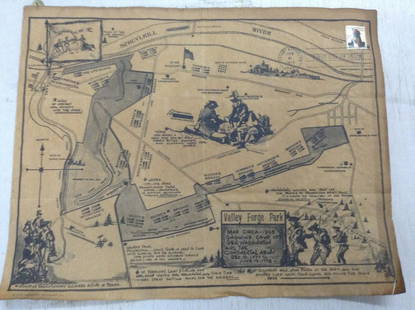
Sold2020early first day cover of Valley Forge w stamp and mapearly first day cover of Valley Forge w stamp and mapSee Sold Price
Sold2021In Darkest Africa by H.M. Stanley 1st Ed. w/ MapsOffered for sale is a first edition, two volume set of “In Darkest Africa” by H.M. Stanley. Perhaps no adventurer is more closely connected with Africa than Lord Stanley, whose various expeditionsSee Sold Price
Sold2021Map of the City of CambridgePublication Date: c1890 Title: Map of the City of Cambridge Cartographer: BURROUGHS,HENRY T. Height (inches): 13.8 Width (inches): 28.6 "published for the Cambridge Directory by W.A. Greenough & Co."See Sold Price
Sold2021Beers & Co 1873 Atlas Columbia County, NY w/ Color Maps1873 Atlas of Columbia County New York, with engravings by Worley & Brocher. First edition hardcover folio with debossed covers and gilt title. Atlas pages have amazingly detailed and colorful hisSee Sold Price
Sold2017Fifty Years of New York Steam Service by NY Steam CorpFirst edition. Quarto. 135 pp; color and b/w illustrations, maps, and b/w photographs throughout. Cloth-backed green felt boards with illustration mounted on cover. Very good, a clean, unmarked copy;See Sold Price
Sold2017A Brief History of the Hawaiian People. AlexanderA Brief History of the Hawaiian People. alexander, W.D. First edition. New York: American Book Company, (1891). Illustrated with maps, photos, and plates. With appendices and an index. Please note thaSee Sold Price
Sold2021Two WWII Illustrated Campaign Maps FramedOperations of First United States Army in Europe from June 6, 1944 to May 9, 1945, surrounded by division logos. Measures 20"H x 19.5"W framed, 17.75"H x 18"W unframed. First U.S. Army & Fifth USSR CaSee Sold Price
Sold2022LINCOLNSHIRE Directories, etc:LINCOLNSHIRE Directories, etc: LINCOLNSHIRE Directories, etc: White, W: The History and Directory of the Towns and Principal Villages in the County of Lincoln. Leeds, 1826. No map present. Cont. fullSee Sold Price
Sold2021Scarce 1st ed. map of Florida, O. W. Gray 1873Title: Scarce 1st ed. map of Florida, O. W. Gray 1873 Description: From the first edition of Gray’s Atlas of the United States by O. W. Gray. “Gray’s Atlas Map of Florida” was published 1873 bSee Sold Price
Sold2021The Country Houses of England 1948 - 1998First edition. Pictorial dust-jacket with title. Publishers navy cloth with silver title to spine. Full-page colour + b &w illustrations and maps. In-text illustrations. This book explores the survivaSee Sold Price
Sold2023The Crossing of AntarcticaSIGNED First edition. Publishers blue cloth with silver title to spine. Map endpapers. Colour double title page. Full-page colour plates. Full-page b & w plates. Full-page maps. A very lovely copy. PuSee Sold Price
Sold2022The Netherlands. 1st French Empire Belgium w/ 13 Départements. THOMSON 1830 mapTITLE/CONTENT OF MAP: 'Belgium or the Netherlands' Belgium shown under the First French Empire, with 13 Départements; although Napoleon's rule over the region had ended with his defeat at WaterloSee Sold Price
Sold2020Life in the Rocky Mountains by Ferris 1940Life in the Rocky Mountains by W. A. Ferris. 1940 first edition with dust jacket clipped. Fred A. Rosenstock. The Old West Publishing Co., Denver, Colorado. 365 pp. Illustrated. One fold-out map. RedSee Sold Price
Sold2020The Voyages of Captain ScottRetold from 'The Voyage of the Discovery"' and 'Scott's Last Expedition'. First edition. Gift inscription inside. Frontispiece portrait. Full-page colour and b & w illustrations. 1 Fold-out map. SporaSee Sold Price
Sold2015H.L. Leonard 10' 3pc / 2 Mid / 4 Tip Fly RodCirca 1879 - 1887 and displaying the "H.L. Leonard/Maker/W. Mills & Son/ N' York/ Sole Agents" stamp of that period, which is the first marking used after leaving Bangor. Rod is wrapped red with fullSee Sold Price
Sold2023The Horseman's Year 1947 - 1948First edition. Edited by Lt.-Col. W. E. Lyon. Pictorial dust-jacket with title. Publishers yellow cloth with gilt title to spine. Colour map endpapers. Colour frontispiece plate. Full-page and in-textSee Sold Price
2 days LeftJasper521816 VOYAGE TO ABYSSINIA by HENRY SALT w/ MAP antique 1st AMERICAN EDITION rare$400
2 days LeftJasper521792 ANCIENT HISTORY of INDIA antique ILLUSTRATED w/ MAPS 18th CENTURY in FRENCH$170
3 days LeftThe Bidder AuctionsHolocaust. Zaglady Ghetta w Krakowie (13.III.1943-13.III.1946), ed. M. Borwicz, illustr., Woodcuts$50


![First printing, first state w/ map of Winesburg: Heading: Author: Anderson, Sherwood Title: Winesburg, Ohio: A Group of Tales of Ohio Small Town Life Place Published: New York Publisher:B.W. Huebsch Date Published: [1919] Description](https://p1.liveauctioneers.com/642/260603/135711957_1_x.jpg?height=310&quality=70&version=1662503729)


![[MAP]. SMITH, W.H., compiler. Smith’s Brooklyn Directory, f...: [MAP]. SMITH, W.H., compiler. Smith’s Brooklyn Directory, for the Year Ending May 1st, 1857. Being a Directory of the Inhabitants with an Avenue and Street Guide, and an Appendix. Brooklyn: Char](https://p1.liveauctioneers.com/928/274602/144224359_1_x.jpg?height=310&quality=70&version=1673894333)


![[The Thames] Tombleson (1 of 1)](https://p1.liveauctioneers.com/94/330664/178342457_1_x.jpg?height=282&quality=70&version=1716466933)

![[LITERATURE - BRITISH]. A large group of 18 works, including: (1 of 1)](https://p1.liveauctioneers.com/197/329405/177652685_1_x.jpg?height=282&quality=70&version=1715364568)


![[Woman traveller - French Revolution] (1 of 1)](https://p1.liveauctioneers.com/94/330664/178342176_1_x.jpg?height=282&quality=70&version=1716466933)


