Sold2023Bartholomew's "Half-Inch to Mile" Map of England & Wales. Dorset Sheet 34Publication Date: c1920 Title: Bartholomew's "Half-Inch to Mile" Map of England & Wales. Dorset Sheet 34 Cartographer: BARTHOLOMEW, JOHN Publisher: THE EDINBURGH GEOGRAPHICAL INSTITUTE, JOHN BARTHOLOMSee Sold Price
Sold2018Weller: Antique Map of England & Wales NW, 1863TITLE/CONTENT OF MAP: 'England & Wales, North-West sheet' Cumbria Lancashire Welsh coast Isle of Man. DATE PRINTED: 1863 IMAGE SIZE: Approx 45.5 x 32.5cm, 17.75 x 12.75 inches (Large) TYPE: Antique maSee Sold Price
Sold2018Bartholomew: Antique Map of England & Wales, 1890Title/Content of Map: England & Wales Date Printed: 1890 Cartographer: BARTHOLOMEW, JOHN & CO. Size (inches): 11.25X11.6 "By J. Bartholomew, F.R.G.S." Polar projection. 11 Shows nautical routes. FromSee Sold Price
Sold2021England And Wales.Map #: 5152 Publication Date: c1885 Title: England And Wales. Cartographer: STANFORD, EDWARD Publisher: EDWARD STANFORD Height: 26.6 Width: 22.6 Scale... 16 miles to 1 inch. ... London atlas series. SSee Sold Price
Sold2021HISTORICAL MAP OF ENGLAND & WALESlithograph on paper mounted to cardboard; John Bartholomew and Son, Edinburgh, 1965; Provenance: The Freund Family Collection; Condition: unframed; toning throughout; 39 x 26 inchesSee Sold Price
Sold2018British Views - Kent 18th-19th Lot of 17 Copper PlatesCopper Plates including one small map. Examples by Beauties of England and Wales, Grose, Boswell, Antiquarian Itinerary, Skelton and others. Paper Size: Up to 11 x 8 inch (28 x 20cm) Some toning and sSee Sold Price
Sold2021Moule, Thomas C1840 British Map. Bath & BristolSteel Engraved Map Published C1840, London for "A Complete and Universal English Dictionary" by the Rev. James Barclay et al. Maps by Thomas Moule. Paper Size: 11 x 8.5 inch (28 x 22cm) Large Closed tSee Sold Price
Sold2021Encyclo. Britannica C1830 Set of 4 Maps on 8 SheetsIncl England/Wales, France, Ireland and Germany. Steel Engraved Map Published 1830-42, Edinburgh for "Encyclopedia Britannica" Seventh Edition. Centre fold as issued. Paper Size: 16 x 11 inch (40 x 28See Sold Price
Sold2018British Views & Maps 19th Century Lot of 11Engravings and Lithographs. Examples by Beauties of England and Wales, Brandard, Harding, Cattermole, Hearne and Byrne. Map examples by Becker & Bartholomew. Paper Size: Up to 15.5 x 10 inch (39 x 25cSee Sold Price
Sold2024BARTHOLOMEWS REVISED HALF INCH CONTOURED MAPS VINTAGE ANTIQUEBARTHOLOMEWS REVISED HALF INCH CONTOURED MAPS VINTAGE ANTIQUESee Sold Price
Sold2024BARTHOLOMEWS REVISED HALF INCH CONTOURED MAPS VINTAGE ANTIQUEBARTHOLOMEWS REVISED HALF INCH CONTOURED MAPS VINTAGE ANTIQUESee Sold Price
Sold2020Woolwork picture: "Capture of Canton by the Allies,Woolwork picture: "Capture of Canton by the Allies, December 28, 1857". England, second half 19th century. Wool and silk on canvas, framed. 19 1/2 in. x 32 in. (sight) PROVENANCE: Estate of Heidi BingSee Sold Price
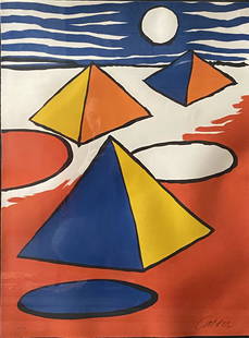
Sold2020Alexander Calder "Pyramids at night" lithographALEXANDER CALDER (American, 1898ñ1976), "Pyramids at Night", 1970 lithograph in colors, sheet: 28.75 x 21.5 inches; overall with frame: 38.25 x 30.5 inches, pencil signed lower right: 'Calder'; numSee Sold Price
Sold2024Mucha, Alphonse Lithograph Untitled signed Mucha 1928Mucha, Alphonse (Czech 1860-1939) Black and white Lithograph, signed in plate 'Mucha 28' Approximate weight: 12lbs Approximate measurements: Sheet 22 inches x 35.5 inches, framed 25.25 inches x 39.75See Sold Price
Sold2021WILLEM DE KOONING (1904 - 1997):"FIGURE AT GERARD BEACH1971 lithograph on wove paper signed and numbered 32/32 catalog raisonne: Graham 24; Knoedler sheet size: 40 x 28 inches Condition: good. Framed under Plexiglas. Slight waving to paper from hinges. NoSee Sold Price
Sold2023Robert Motherwell London Red Color Serigraph Ed150Robert Motherwell London Red Color Serigraph Ed150, from the London series, overall sheet approx 41 x 28 inches, 41.375 x 28.75 x 1.375 inches framed, signed Motherwell and numbered 74 of 150 in penciSee Sold Price
Sold2022(CIVIL WAR.) John Bachmann. Panorama of the Seat of War.(CIVIL WAR.) John Bachmann. Panorama of the Seat of War. Portfolio of 6 double-page chromolithographed panoramic perspective maps of Confederate states. Folio, 23½x17 inches, contemporary half moSee Sold Price
Sold2022ORTELIUS, ABRAHAM. Typus Orbis Terrarum.ORTELIUS, ABRAHAM. Typus Orbis Terrarum. Double-page engraved map of the world. 16¾x20½ inches sheet size, wide margins, Dutch text on verso; original hand-color; professionally conserved wiSee Sold Price
Sold2023Robert Motherwell Basque Suite No7 Color Screenprint Ed150Robert Motherwell Basque Suite No7 Color Screenprint Ed150, Image 7 from the Basque Suite, overall sheet approx 40.5 x 28 inches, 41.375 x 25.625 x 1.375 inches framed, hand signed with monogram and nSee Sold Price
Sold2022DES BARRES, JOSEPH FREDERICK WALLET The North East Shore of the Gulph of Mexico. London: circa 1780.DES BARRES, JOSEPH FREDERICK WALLET The North East Shore of the Gulph of Mexico. London: circa 1780. A very large hand-colored engraved map on four joined sheets. Overall 30 x 84 inches (76 x 214 cm).See Sold Price
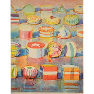
Sold2016Wayne Thiebaud "Colorful Cakes" lithographWAYNE THIEBAUD (Californian b. 1920) Colorful Cakes Color lithograph Sheet: 37 3/4 x 28 7/8 inches / 95.88 x 73.34 cm Signed and dated lower right: Thiebaud, 1990 Condition: In overall very good condiSee Sold Price
Sold2020Thomas Hart Benton "The new Proprietors" ink and washTHOMAS HART BENTON (American 1889-1975) "The New Proprietors" ink and wash on paper, sheet: 11.125 x 14.125 inches / 28.26 x 35.87 cm; Frame: 16 3/8 x 18 1/2 inches, signed in ink lower left: Thomas HSee Sold Price
Sold2022ORTELIUS, ABRAHAM. Americae Sive Novi Orbis, Nova Descriptio.ORTELIUS, ABRAHAM. Americae Sive Novi Orbis, Nova Descriptio. Double-page engraved map of the Western Hemisphere. 17½x22¼ inches sheet size, wide margins, Spanish text on verso; uncolored; cSee Sold Price
Sold2016GUSTAVE BAUMANN "The Way of the Years" Woodblock.GUSTAVE BAUMANN (New Mexico / Californian 1881-1971) The Way of the Years Color woodblock print Sheet: 11 1/4 x 11 inches / 28.57 x 27.94 cm Signed lower right: Gustave Baumann with the hand - hart chSee Sold Price
6 days LeftJasper52OS #44 Cotswolds. Cheltenham Broadway Burford Moreton Gloucestershire 1828 map$280
6 days LeftSwann Auction Galleries(CANADA.) Nicolas Visscher. Carte Nouvelle Contenant la Partie d'Amerique la Plus Septentrionale,$450
6 days LeftSwann Auction Galleries(NEW ENGLAND.) Johannes van Keulen. Pas-Kaart vande Zee Kusten van Niew Nederland Anders Genaamt$2,200
2 hrs LeftFreeman's | Hindman[MORMONS]. MILLROY & HAYES (fl. 1899). Route of the Mormon Pioneers from Nauvoo to Great Salt Lake,$300
Jun 23Leonard Auction, a division of The Leonard CompanyAlexander Calder (American, 1898-1976) Lithographs$150


![[MORMONS]. MILLROY & HAYES (fl. 1899). Route of the Mormon Pioneers from Nauvoo to Great Salt Lake, (1 of 2)](https://p1.liveauctioneers.com/197/329395/177650560_1_x.jpg?height=282&quality=70&version=1715364962)


