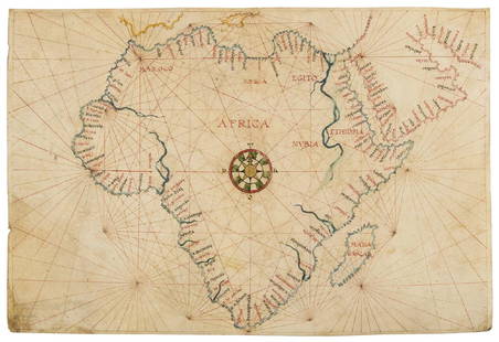
Sold2019Africa.- Agnese (Manner of Battista, c.1500-1564)Africa.- Agnese (Manner of Battista, c.1500-1564) Portolan chart of Africa and the Arabian Peninsula, large compass rose with port towns and cities annotated, pen and inks, watercolour wash, heighteneSee Sold Price
Sold2023Dept 56 Navigational Charts & Maps New England Village Series Heritage Village CollectionDepartment 56 Navigational Charts & Maps New England Village Series Heritage Village Collection Christmas Village Building with Original BoxSee Sold Price
Sold20173 Framed Vintage Maps Navigational & Geological3 Framed Vintage Maps, both Navigational & Geological in nature. Representing the Atlantic Ocean, Barre, VT, and Biddeford, ME, containing Kennebunkport. All measure 21 x 17 inches.See Sold Price
Sold2019Giovanni Battista Albrizzi (1698-1777) Map of CanadaA hand colored engraving, from "Atlante Novissimo che Contiene Tutte le Parti del Mondo", circa 1740, after Guillaume de L'Isle (1675 - 1726). Dimensions: Sight 14 1/4" x 18 1/4", the frame 24 3/4" xSee Sold Price
Sold2018The Decline And Fall Of The Roman Empire Vol. 1-3The Decline And Fall Of The Roman Empire Vol. 1-3; Three volumes in illustrated hardcovers, Cumulative index, v.3; illustrations by Gian Battista Piranesi throughout. Maps on endpapers. Printed on toSee Sold Price
Sold2018Ramusio: Hispaniola with Sea Monsters, 1565Reserve Reduced! Title of Map: Isola Spagnuola Cartographer: Giovanni Battista Ramusio Place/Date: Venice / 1556/1565 Size: 10 1/2" x 6 3/4" Condition: b&w; overall age toning Derived from the rare 15See Sold Price
Sold20181984 NOAA New York Harbor Navigational ChartTitle/Content of Map: 1984 NOAA New Your Harbor Navigational Chart Issued for Statue of Liberty Centennial -- United States East Coast; New York - New Jersy; New York Harbor Date Printed: 1984, WashinSee Sold Price
Sold2017De Wit Portolan Sea Chart of EuropeTotius Europae Victoria... Frederic De Wit (1630-1706). Engraved map with original hand color. Amsterdam, 1675. 20 x 35 1/2 inches sheet, 27 1/2 x 43 inches framed. “The most striking and decorativeSee Sold Price
Sold2020Rasmusio and Gastaldi Map of Eastern Seaboard 160Giovanni Battista Rasmusio (1485-1557) and Giacomo Gastaldi (1500-1566), "La Nuova Francia," Venice, 1606. Woodcut map depicting the eastern seaboard of the United States and Canada from New York BaySee Sold Price
Sold2022[RAMUSIO, GIOVANNI BATTISTA. 1485-1557.] [Brasil]. [Venice: c.1565 or later].[RAMUSIO, GIOVANNI BATTISTA. 1485-1557.] [Brasil]. [Venice: c.1565 or later]. Woodcut map of Brazil, 310 x 410 mm. The seas decorated with galleons and monsters, the land showing habitations and nativSee Sold Price
Sold2018Bellin: Cayenne to Martinique Navigational ChartMap: Carte Reduite pour la Navigation de Cayenne a la Martinique Cartographer: Bellin Place/Date: Paris / 1764 Size: 29" x 21 1/2" Condition: wash and outline color. some repaired marginal tears BelliSee Sold Price
Sold2018Bellin: Cayenne to Martinique Navigational ChartMap: Carte Reduite pour la Navigation de Cayenne a la Martinique Cartographer: Bellin Place & Date: Paris / 1764/1790s Size: 29" x 21 1/2" Condition: b&w; a strong impression, with some very light oveSee Sold Price
Sold2018Bellin: Antique Map of Portobelo Bay, Panama, 1764Baye de Porto-belo et Costes Voisines Bellin's highly detailed chart of the Bay of Portobello in Panama and its "neighboring coasts" features good topographical and navigational details (shoals, sandbSee Sold Price
Sold2017Maps, Charts, Globes: Five Centuries of ExplorationTitle: Maps, Charts, Globes: Five Centuries of Exploration. A New Edition of E.L. Stevenson's Portolan Charts and Catalogue of the 1992 Exhibition New York. The Hispanic Society of America. 1992 AuthoSee Sold Price
Sold2022Exact Chart of the River St. Laurence, Thomas Jeffreys c1775Historically important chart published during the American Revolutionary War. An incredibly impressive and large vintage map in immaculate condition. Contains geographical and navigational data alongSee Sold Price
Sold2021Group of Assorted CartographsGroup of Assorted Cartographs including a group of 8 assorted navigational charts of various locations, a modern reproduction of Heinrich Bunting's Asian map in Pegasus form, a vintage map of the IslaSee Sold Price
Sold2022Borrassà LluÃs seguace di, San Giovanni Battista e San Giovanni Evangelistatempera su tavola a fondo oro, W. 85 - H. 123 Cm, Expertise Aldo Bertini, 10 V 1968 (“opera rara e significativa di scuola catalana, del primo decennio del Quattrocento all’incirca, nellaSee Sold Price
Sold2024CIRCLE OF GIOVANNI BATTISTA TIEPOLO.Saint Roch with a Dog. Oil on canvas or Oil on paper laid to canvas. Unsigned. Verso: inscribed 'Brauer Tiepolo'. From a Ridgefield, CT estate. For more photos, please visit www.ClarkeNY.com and findSee Sold Price
Sold2022John Smith Map of New England, Extremely Rare 2nd StateSMITH, John (1580-1631). New England the most remarqueable parts thus named by the high and mighty Prince Charles, Prince of great Britaine. Observed and described by Captayn John Smith... CopperplateSee Sold Price
Sold2022Piranesi, Giovanni Battista - Roman antiquities ... divided into four volumes - Of the magnificenceRome, in the Salomoni printing house in the square of S. Ignazio, 1784. In Atlantic folio, 415 x 540 mm., 4 volumes, editorial hardcover by the Piranesian printing house. The first volume of Roman AntSee Sold Price
2021GREAT NORTHERN’S 2 GREAT TRAINS SYSTEM MAP.Huge dramatic reverse glass advertising Great Northern's two great trains, Empire Builder and Western Star. In script just below Great Northern logo it states "Steamliners twice a day, each way, betweSee Sold Price
Sold2022[STREETER COPY] SEARCY, I. G. Map of Florida constructed principally from authentic documents in the[STREETER COPY] SEARCY, I. G. Map of Florida constructed principally from authentic documents in the Land office at Tallahassee by I. G. Percy. Published by I.G. Searcy Tallahassee & F. Lucas Jr., BalSee Sold Price
Sold2022Naldini Giovanni Battista, Compianto sul Cristo mortoolio su tavola, W. 45 - H. 55 Cm, Collezione Molinari Pradelli, Castenaso (BO), La Bottega di San Luca, Torino, 2003, Collezione privata, Torino, "Firenze e la Toscana dei Medici nell'Europa del '500"See Sold Price
Sold2018Portolan Chart of SicilyIlluminated manuscript portolan chart on vellum of Sicily “Isola. D. Sicilia”. Jouanne Oliva (fl. 1570-1614). Marseilles, 1600. Single leaf of vellum, float-mounted and framed. 20 x 28 inches sheeSee Sold Price
4 days LeftJasper521756 Mexican port of Zihuatanejo, also known as Chequetan or Seguatanco, was depicted by the English$20
5 days LeftJasper52Bahamas. San Salvador Crooked Rum Cay Mariguana ADMIRALTY chart 1892 (1919) map$140
5 days LeftJasper52West India Islands & Caribbean Sea Sheet 2 ADMIRALTY sea chart 1913 (1949) map$120
5 days LeftJasper52Jamaica & the Pedro Bank. South Cuba Haiti. ADMIRALTY sea chart 1866 (1968) map$120
5 days LeftJasper52Venezuela Coast Trinidad Tobago Isla Margarita ADMIRALTY chart 1894 (1950) map$120
5 days LeftJasper52Kingston approach Jamaica south coast Caribbean ADMIRALTY chart 1962 (1966) map$120
Featured5 days LeftJasper52Jamaica SE coast Morant-Portland Pt Kingston ADMIRALTY sea chart 1963 (1971) map$120
Featured5 days LeftJasper52Barbuda Island. West Indies Caribbean. ADMIRALTY sea chart 1850 (1966) old map$120
5 days LeftJasper52Grand Bahama & Great Abaco Islands. Bahamas. ADMIRALTY sea chart 1886 (1968) map$140
5 days LeftJasper52Bahamas harbours Pelican Abaco Berry I Jumentos ADMIRALTY chart 1899 (1920) map$140
Featured5 days LeftJasper52Havana Harbour, Cuba. Caribbean. ADMIRALTY sea chart 1954 (1955) old map$140
5 days LeftJasper52Antigua Falmouth English Harbour West Indies ADMIRALTY sea chart 1954 (1968) map$280
Featured5 days LeftJasper52Anguilla St. Martin/Maarten Barts. Caribbean. US Navy sea chart 1899 (1917) map$280
May 11Trillium Antique Prints & Rare BooksPiranesi, Rare, Large Folio - The Trophy Staircase [Reference Robison 34 (V/VI)]$1,000
May 14Fleischer's Auctions1755 Map Partie de l'Amerique Septentrionale, qui comprend Le Cours de L'Ohio...$200(3 bids)
2 days LeftTremont Auctions17th century original map 1676 "Virginia and Maryland" by John Speed. 2 sided framing. Overall:$650(3 bids)
2 days LeftTremont AuctionsJohn Speed and Francis Lamb "Map of New England and New York", ca. 1676. Hand colored engraved map$900(3 bids)


![[RAMUSIO, GIOVANNI BATTISTA. 1485-1557.] [Brasil]. [Venice: c.1565 or later].: [RAMUSIO, GIOVANNI BATTISTA. 1485-1557.] [Brasil]. [Venice: c.1565 or later]. Woodcut map of Brazil, 310 x 410 mm. The seas decorated with galleons and monsters, the land showing habitations and nativ](https://p1.liveauctioneers.com/1043/241341/125120008_1_x.jpg?height=310&quality=70&version=1647624550)


![[STREETER COPY] SEARCY, I. G. Map of Florida constructed principally from authentic documents in the: [STREETER COPY] SEARCY, I. G. Map of Florida constructed principally from authentic documents in the Land office at Tallahassee by I. G. Percy. Published by I.G. Searcy Tallahassee & F. Lucas Jr., Bal](https://p1.liveauctioneers.com/292/250642/130213737_1_x.jpg?height=310&quality=70&version=1654271664)


![Piranesi, Rare, Large Folio - The Trophy Staircase [Reference Robison 34 (V/VI)] (1 of 2)](https://p1.liveauctioneers.com/6581/328611/177002408_1_x.jpg?height=282&quality=70&version=1714745066)


