Sold2019Astronomy.- Newton.- Muggletonians.- Frost (Isaac) TwoAstronomy.- Newton.- Muggletonians.- Frost (Isaac) Two Systems of Astronomy: first, the Newtonian System, showing the rise and progress thereof, by a short historical account: the general theory, withSee Sold Price
Sold2019Map of Northern California, Showing Progress ofReserve Reduced! Title: Map of Northern California, Showing Progress of Topographic Surveying and Primary Control Publication Date: 1906 Cartographer: U.S.G.S. Publisher: U.S.G.S. Size (inches): H9.5See Sold Price
Sold20151901 Map showing progress of allotment in Indian CreekMap showing progress of allotment in Creek Nation- Exhibit, col,. comp. and drawn by C.H. Dana. NY: U.S. Department of the Interior, Julius Bien Photo Lithograph, 190120 mile scaleDimensions: 24 1/4"See Sold Price
Sold20181737 Georgia Documenttwo-page document signed by Benjamin Martyn and dated May, 1737, authorizing the shipment of "sixty heads" from Rotterdam to Georgia, scarce document dealing with populating the Georgia colony with inSee Sold Price
Sold2021Creek and Seminole Nations Indian Territory. ShowingPublication Date: c1904 Title: Creek and Seminole Nations Indian Territory. Showing Progress of Allotments Cartographer: DANA, C. H. Publisher: U.S. DEPARTMENT OF THE INTERIOR. COMMISSION TO THE FIVESee Sold Price
Sold20191901 Bien Seminole Nation Map -- Map of Seminole NationTitle/Content of Map: 1901 Bien Seminole Nation Map -- Map of Seminole Nation Showing Progress of Allotment Date: 1901, Washington Cartographer: J Bien & Co. Size: 19 x 10 in. This map shows in greatSee Sold Price
Sold2019U S Coast Survey 1896 LG Map. Gulf Coast. Florida, MI"Sketch Showing Progress of Surveys on the Gulf Coast Lake Pontchartrain Mobile and Pensacola Bays" Detailed map showing New Orleans to Santa Rosa Sound, with inset showing Tortugas Harbor. Large LithSee Sold Price
Sold2023Sketch F showing the progress of the survey in Section No. VI from Cape Florida to Tortugas IslandsTitle: Sketch F showing the progress of the survey in Section No. VI from Cape Florida to Tortugas Islands from 1845 to 1861 Cartographer: Publisher: U.S. Coast Survey Height: 19.8 Width: 34 ExceptionSee Sold Price
Sold2022Sketch I Showing the Progress of the Survey in Section No.9 [Texas Gulf Coast]Publication Date: 1853 Title: Sketch I Showing the Progress of the Survey in Section No.9 [Texas Gulf Coast] Cartographer: ANONYMOUS Publisher: U.S. COAST SURVEY Height: 17.5 Width: 21.6 TriangulationSee Sold Price
Sold2023UNITED STATES COAST SURVEY SHOWING THE PROGRESS OF THE SURVEY DURING THE YEAR 1866UNITED STATES COAST SURVEY SHOWING THE PROGRESS OF THE SURVEY DURING THE YEAR 1866For the House of Representatives, 39th Congress, 2d Session, Ex. Doc. No. 87, Government Printing Office, Washington,See Sold Price
Sold2020Sketch C Showing the Progress of Section No.III fromPublication Date: 1861 Title: Sketch C Showing the Progress of Section No.III from 1843 to 1860 Cartographer: U.S. COAST SURVEY Publisher: GPO Height: 34.25 Width: 22.75 Triangulation of Chesapeake BaSee Sold Price
Sold2021Sketch F. Showing the Progress of the Survey in SectionPublication Date: 1856 Title: Sketch F. Showing the Progress of the Survey in Section VI With a General Reconnoissance of The Coast Of Florida 1848-56 Cartographer: BACHE, A.D. Publisher: U.S. COAST SSee Sold Price
Sold2021Sketch I Showing the Progress in Section No.Ix fromTitle: Sketch I Showing the Progress in Section No.Ix from 1848 to 1866 [Vicinity of Galveston] Cartographer: U.S. COAST SURVEY Publisher: GPO Size: 10 X 25 Shows triangulation of Galveston Bay. A litSee Sold Price
Sold2022Sketch G Showing the Progress in Section No. 7 ...Title: Sketch G Showing the Progress in Section No. 7 ... Date: 1850 Cartographer: U.S. COAST SURVEY Publisher: U.S. COAST SURVEY Description: in the year 1849 reconnoissance of Pensacola and PerdidoSee Sold Price
Sold2024Sketch I Showing the Progress of the Survey in Section No.9 1848 to 53Publication Date: 1853 Title: Sketch I Showing the Progress of the Survey in Section No.9 1848 to 53 Cartographer: U.S. COAST SURVEY Publisher: U.S. COAST SURVEY Height: 7.3 Width: 21.6 The year afterSee Sold Price
Sold2023Sketch Showing the Progress of the Survey On The Atlantic, Gulf of Mexico and Pacific Coast Of ThePublication Date: 1870 Title: Sketch Showing the Progress of the Survey On The Atlantic, Gulf of Mexico and Pacific Coast Of The United States to November 1870 Cartographer: PIERCE, BENJAMIN PublisherSee Sold Price
Sold2017Hand-Colored Lithograph Map of the Gulf of MexicoImpressive Hand-Colored Lithograph Map of the Gulf of Mexico, titled "U.S. Coast Survey, A.D. Bache Superintendent, Sketch H, Showing the Progress of the Survey in Section No. 8, 1846-1854", the map iSee Sold Price
Sold2017Benjamin Rabier Silver Nursery Rhyme Knife RestsBenjamin Rabier Silver Nursery Rhyme Knife Rests. Signed Benjamin Rabier. Showing scenes from famous fables and nursery rhymes. Each measures 3.5 inches in width.See Sold Price
Sold2017Florida Lithograph MapU.S. Coast Survey Sketch F Showing the Progress of the Survey in Section V. A.D. Bache (1806-1867). Lithographed map. Washington, D.C., 1855. 23 x 16 1/2 inches visible, 27 1/4 x 21 1/2 inches framedSee Sold Price
Sold20241954 Pennsylvania Railroad Calendar-Pittsburgh Promotes ProgressThis is a 1954 Pennsylvania Railroad Calendar, with the artwork titled Pittsburgh Promotes Progress showing the railroad in and around Pittsburgh, PA. Unlike many of these calendars, this one, as wellSee Sold Price
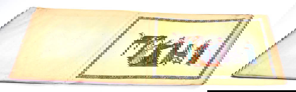
Sold2024Chinese Hand Painted Silk BookHorizontal to size, Qing Dynasty with 12 pages cut out silk applied to rice paper showing the progress of a noble from before his birth to his death in twelve panels, bound in red silk covered card stSee Sold Price
Sold2018Chart of Outer Banks, 1853 U. S. Coast SurveyReserve Reduced! Hand-colored chart of the Outer Banks on the east coast of North Carolina and Virginia. “Sketch D Showing the Progress of Section IV, 1845-1853.” Area shown includes Albemarle SouSee Sold Price
Sold20241956 Pennsylvania Railroad Calendar-Dynamic ProgressThis is a 1956 Pennsylvania Railroad Calendar, with the artwork titled Dynamic Progress, showing the updated passenger and freight equipment in use near Harrisburg, PA, on the PRR. Unlike many of thesSee Sold Price
Sold2018U.S Coast Survey 1857 Map. New Orleans, Louisiana"Sketch II Showing The Progress of the Survey in Section No. VIII" A Rare Map centred on New Orleans and Lake Pontchartrain. Also showing Bon Secours Bay (Alabama) Isle au Breton Sound and Vermilion BSee Sold Price
6 days LeftHolabird Western Americana CollectionsEarly California Voyagers (2 Books) 1933, 1927 [182272]$75
2 days LeftSchilb Antiquarian Rare Books1856 Benjamin Franklin Life & Autobiography Essays Marriage Slavery Chess Wealth$230(4 bids)
Jun 12Dan Morphy AuctionsPLATE CXIII. MAP OF INDIAN TERRITORY SHOWING DISTRIBUTION OF WOODLAND” FROM THE TWENTY-FIRST$100
Jun 27Rail & Road AuctionsGroup of Norfolk and Western Railroad Paper - Ink Blotters, 1926 Travel Book, and More$30
4 days LeftToomey & Co. AuctioneersFrank Lloyd Wright, Six-panel folding screen from the Benjamin Adelman House, Phoenix, Arizona$3,000
Jun 16Broward Auction GalleryBenjamin Eugene Fichel (France,1826-1895) oil painting antique$20(2 bids)
21 hrs LeftGalerie Moenius AGA MONUMENTAL AND VERY RARE RUSSIAN ICON SHOWING THE APOSTLES TO THE SLAVS CYRIL AND METHODIUS WITH€4,000
21 hrs LeftGalerie Moenius AGVERY RARE RUSSIAN METAL ICON SHOWING THE HOLY TRINITY (OLD TESTAMENT TYPE), THE DEESIS AND SAINTS€2,000(2 bids)
694 Lots AwayHermann Historica GmbHA Russian icon showing the Iverskaya Mother of God with silver filigree oklad, 19th century (icon),See Sold Price
118 Lots AwayHermann Historica GmbHA large Chinese wood-glazed famille rose brush pot showing a mountain and river scene with YongzhengSee Sold Price
21 hrs LeftGalerie Moenius AGEXTREMELY RARE RELIQUARY ICON WITH SILVER OKLAD AND INSET SILVER CROSS SHOWING THE CRUCIFIXION OF€5,000


![Sketch I Showing the Progress of the Survey in Section No.9 [Texas Gulf Coast]: Publication Date: 1853 Title: Sketch I Showing the Progress of the Survey in Section No.9 [Texas Gulf Coast] Cartographer: ANONYMOUS Publisher: U.S. COAST SURVEY Height: 17.5 Width: 21.6 Triangulation](https://p1.liveauctioneers.com/5584/270923/141842822_1_x.jpg?height=310&quality=70&version=1670433092)


![Sketch I Showing the Progress in Section No.Ix from: Title: Sketch I Showing the Progress in Section No.Ix from 1848 to 1866 [Vicinity of Galveston] Cartographer: U.S. COAST SURVEY Publisher: GPO Size: 10 X 25 Shows triangulation of Galveston Bay. A lit](https://p1.liveauctioneers.com/5584/192977/97277009_1_x.jpg?height=310&quality=70&version=1612304273)


![History of Idaho, 3 Vols., 1914 [182274] (1 of 6)](https://p1.liveauctioneers.com/2699/331494/178785530_1_x.jpg?height=282&quality=70&version=1717094654)
![Early California Voyagers (2 Books) 1933, 1927 [182272] (1 of 9)](https://p1.liveauctioneers.com/2699/331494/178785429_1_x.jpg?height=282&quality=70&version=1717094654)