Sold2022Disneyland 1962 Souvenir Map. Walt Disney Productions, 1962...Disneyland 1962 Souvenir Map. Walt Disney Productions, 1962. Color park map. Inset detail of monorail service to Disneyland Hotel. First appearance of the Enchanted Tiki Room and Pirates of the CaribbSee Sold Price
Sold20181852 Philip Map of North and South America -- AmericaTitle/Content of Map: 1852 Philip Map of North and South America -- America Date: 1852, Liverpool Cartographer: G Philip Size: 11.9 x 9. 1 in. This is a handsome map of the Americas, offering detailsSee Sold Price
Sold2022(NEW YORK.) John Homer French. The State of New York from New and Original Surveys.(NEW YORK.) John Homer French. The State of New York from New and Original Surveys. Large hand-colored engraved wall map of New York with many inset views and detail maps. 4 sheets joined, 68x73 incheSee Sold Price
Sold2018Nolin: Map of the Americas with New Discoveries InsetTitle/Content of Map: Carte d'Amerique divisee en ses principaux etats. Cartographer: J. B. Nolin Place & Date: Paris / 1818 Size: 28 1/2" x 20 1/4" Condition: Wash color; overall age toning; some papSee Sold Price
Sold2021Map of Texan, Indian Terr. & N. Mex., 1868Terrific post-Civil War school atlas map of the region. Map drawn by Oliver J. Stuart. Numerous Indian tribes, counties, towns, forts, rivers, and other details. Inset of Galveston area. Full originalSee Sold Price
Sold2021Large Antique Hanging Map of Columbia County NY 1858Large Antique Hanging Map of Columbia County New York from 1858. Shows details and insets of towns and villages in Columbia county. Has a top piece made to hang on the wall. Has a beautiful patina andSee Sold Price
Sold20171864 hand-colored map of Palestine by S. AugustusA beautiful example of S. A. Mitchell Jr.'s 1864 map of Palestine, Israel or the Holy Land. Updated from the 1860 variant with new details, an inset of Jerusalem, and a new 1864 copyright. Includes boSee Sold Price
Sold2021Antique New York State Map 1903 Color Roll Up RR Map1903 Scarborough's New Railroad, Post Office, Township and County Map of New York. Color map, compiled from the latest government and state surveys and original sources of the era. Insets: Map of NewSee Sold Price
Sold2018de Vaugondy: Americas with Caribbean insetsMap: Amerique ou Indes Occidentales. Cartograper: Robert de Vaugondy Place / Date: Paris / 1771 Size: 25" x 20" Condition: outline color. light overall age toning, minor staining along outer edges ofSee Sold Price
Sold2021Early map with Large Texas & CaliforniaEarly map with large Texas and huge Upper California. Contains an inset of Gold Regions of California and highlights the western half of the United States. Inset shows details of rivers and place nameSee Sold Price
Sold20171907 Cram Map Of Wisconsin1907 Cram Map Of Wisconsin G Cram, 1907, Chicago, 24 x 17.5 in. A nice county map of Wisconsin. Detailed with topographical details, settlements, and railroad lines. Inset is greater Milwaukee. PleaseSee Sold Price
Sold2023Period 1684 Map North and South American by De HudsonThe hand colored map having excellent and vivid details of the Americas. Beautifully etched with Native Americans as well. Framed nicely for display. Good overall condition not having been laid down.See Sold Price
Sold2022Scarce Civil War era map of Florida with great detail,Great map of Florida showing the entire state (includes small inset of Florida Keys). Shows state shortly after the outbreak of the Civil War. Notes proposed course of a canal route from Tampa to theSee Sold Price
Sold2019PHILADELPHIA antique town city map plan. Inset US Bank,TITLE/CONTENT OF MAP: 'PHILADELPHIA' The top image on the right hand side shows the entire map. To view a close up of the map showing the level of printed detail, please click on the bottom image on tSee Sold Price
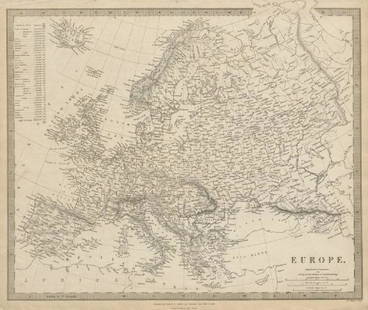
Sold2019EUROPE. General map. Inset table of population &TITLE/CONTENT OF MAP: 'EUROPE; inset table of population by country' The top image on the right hand side shows the entire map. To view a close up of the map showing the level of printed detail, pleasSee Sold Price
Sold2020Scarce hand-colored map of Texas, 1875Attractive and scarce map of Texas with inset map "Western Part of Texas". Exquisite detail with counties painstakingly colored by hand. Interesting map of the growing state developed circa 1875 durinSee Sold Price
Sold2017Johnson’s Civil War era map of North & South CarolinaHistoric map shows the Carolinas in great detail shortly following the outbreak of the Civil War. States hand-colored at the time of publishing with color coding according to county. Inset map depictsSee Sold Price
Sold2018Gold rush Australia showing gold districts in yellow.TITLE/CONTENT OF MAP: 'Australia [inset: Van Diemen's Land]' The top image on the right hand side shows the entire map. To view a close up of the map showing the level of printed detail, please clickSee Sold Price
Sold2018BRITISH EMPIRE. World Mercator. Currents. SteamshipTITLE/CONTENT OF MAP: 'The World (Mercator); Inset map of France' The top image on the right hand side shows the entire map. To view a close up of the map showing the level of printed detail, please cSee Sold Price
Sold2020America.- Colonial Southern United States, Florida.-NO RESERVE America.- Colonial Southern United States, Florida.- Gibson (John) A Map of the New Governments, of East & West Florida, with inset plan of the Harbour and Settlement of Pensacola, publisheSee Sold Price
Sold2018Superb 1852 map of TexasReserve Reduced! Very clean, comprehensive map of Texas, showing the new boundaries after the Compromise of 1850, with inset maps of the panhandle and Galveston. Included are topographical details andSee Sold Price
Sold20171861 Johnson's Map of PalestineItem: 1861 Johnson's Map of Palestine Description: Map of the Holy Land showing topographical and settlement details. Names are font-coded as to being scripture, classical or modern names. Inset are aSee Sold Price
Sold20231763 Map British Governments in North AmericaEngraved folding map of "The British Governments in N(or)th. America Laid down and agreeable to the Proclamation of Oct. 7 1763.", Map of the colonies and other territories to Louisiana. Inset of BermSee Sold Price
Sold2021Nice map of SE coast of U. S. (Colton)Clean map of the southeast coast of the United States, with good detail. Shows railroad lines, towns, rivers, lakes, swamps, islands and coastal features. Inset of the Florida Keys. Full, original hanSee Sold Price
4 days LeftJasper521720 Chatelain Map of Scotland -- Nouvelle Carte d'Ecosse, ou l'on Fait Observer l'Etat de la Nobles$240
4 days LeftJasper521719 Chatelain Map of Russian Empire -- Carte Generale des Etats du Czar Empereur de Moscovie…$320
4 days LeftJasper521795 Lewis Map of Maryland -- The State of Maryland, from the best Authorities$360
Jun 23Schilb Antiquarian Rare Books1848 Emory Military Reconnaissance 1ed California MAP Indians Texas New Mexico$2(2 bids)
4 days LeftJasper521816 VOYAGE TO ABYSSINIA by HENRY SALT w/ MAP antique 1st AMERICAN EDITION rare$400
Jun 13DOYLE Auctioneers & AppraisersUniversal Geneve Gold 'Royal Presentation' Watch, Ref. 10 232.7$4,000
Jun 07Freeman's | HindmanHOMANN, Johann Baptist. Amplissimae Regionis Mississipi Seu Provinciae Ludovicianae. Nuremburg, [ca$400(1 bid)
Jun 04John Moran Auctioneers, Inc.Johnny Lee Pudlat (b. 1971, Inuit; Cape Dorset/Kinngait), A carved stone dancing bear, 2001$200(1 bid)
Jun 02Schilb Antiquarian Rare Books1848 RARE Halls of Montezumas MEXICO Texas America War Zachary Taylor Battles$6(5 bids)
Jun 23Schilb Antiquarian Rare Books1877 Geology Geography Surveys 1ed Nevada Wyoming Utah George Wheeler US West 2v$1


![Gold rush Australia showing gold districts in yellow.: TITLE/CONTENT OF MAP: 'Australia [inset: Van Diemen's Land]' The top image on the right hand side shows the entire map. To view a close up of the map showing the level of printed detail, please click](https://p1.liveauctioneers.com/5584/124870/63536078_1_x.jpg?height=310&quality=70&version=1531863645)


![[MAP]. ORTELIUS, Abraham. Africae Tabula Nova. 1592. (1 of 2)](https://p1.liveauctioneers.com/197/329395/177650533_1_x.jpg?height=282&quality=70&version=1715364962)


