Sold2023ANTIQUE FLORIDA FRAMED MAPS - LOT OF 2148268 ANTIQUE FLORIDA FRAMED MAPS - LOT OF 2 Antique Florida map framed map to include one 1853 U.S. Coast Survey Chart or Map of St. George's Sound, Florida, and one unsigned map of Florida denotedSee Sold Price
2017Antique Nautical Chart of San Francisco Harbor, 1885Map: 1885 British Admiralty Chart of San Francisco Harbor -- North America; West Coast; San Francisco Harbour from United States Coast Survey 1877 Date Printed: 1885, London Cartographer: British AdmiSee Sold Price
Sold2019Western Coast of U. S., 1854 Coast SurveyLarge, impressive nautical chart of the Reconnaisance of the Western Coast of the United States (Middle Sheet) from San Francisco to Umpquah River. Coastal chart of the western coast with twelve vigneSee Sold Price
Sold2019Western Coast of U. S., 1853 Coast SurveyHand-colored, antique nautical chart of the Western Coast of the United States, from Gray’s Harbor to the Entrance of Admiralty Inlet. Coastal chart of the northwestern corner of Washington, Cape FlSee Sold Price
Sold20231914 Maritime Chart Of New York HarborUS Coast Survey Chart dated 1914. This is a nautical anchorage chart of New York Harbor, upper bay and narrows. This particular chart has areas marked where vessels were allowed to anchor in the bustlSee Sold Price
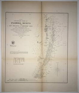
Sold2020(F No.4) Preliminary Chart of Florida Reefs from KeyTitle/Content of Map: (F No.4) Preliminary Chart of Florida Reefs from Key Biscayne to Carysfort Reef... Publication Date: 1855 Cartographer: Totten, Jas./I. Hull Adams Publisher: U.S. Coast Survey DeSee Sold Price
Sold2022Framed Corpus Christi Bay Nautical ChartCorpus Christi nautical chart, 4th ed., dated "May / 10" marked by the National Oceanic and Atmospheric Administration (NOAA), United States Coast and Geodetic Survey height 39 in. x width 49See Sold Price
Sold2023DOC Map, Fowey Rocks to Alligator Reef, Florida East CoastA color map depicting the land and sea area of Fowey Rocks to Alligator Reef. Publishing stamp by "The U.S Coast and Geodetic Survey" located on bottom. Issued: 1921 Dimensions: 46"L x 35"W MaSee Sold Price
Sold2023U S Coast Survey 1856 Large Map. St. Mary's Bar & Fernandina Harbor Florida"Preliminary Chart of St. Mary's Bar and Fernandina Harbor Florida"Large Lithograph Map Published 1857, Washington for "U.S. Coast and Geodetic Survey" Folds as issued. Paper Size: 25 x 23 inch (64 xSee Sold Price
Sold2018Scarce Sea Chart with every building, fort andHarrison, A. M. & Dorr, F. W. et al. Coast Chart No. 59, St. Augustine Inlet to Halifax River Florida. Lithographed map. U.S. Coast and Geodetic Survey, c. 1885. 41 ¼" x 31 ⅛" sheet. Great dSee Sold Price
Sold2020United States, East Coast – Forida Street BritishUnused, very detailed sea chart of the Florida coasts with Miami, Cape Kennedy, the Bahama Banks and so on. The first surveys are from 1898 from Admiralty surveys. Authentic, very detailed sea chart,See Sold Price
Sold2019A.D. Bache U.S. Coast Survey Charts East CoastA.D. Bache: Preliminary Coastal Chart N. 8, Sequin Island to Kennebunkport, Maine 1859. Measures 38” X 22”. Paper size 40" x 24 1/2". Used Condition, creases, burn. electrotype have some sSee Sold Price
Sold2020A.D. Bache U.S. Coast Survey Charts East CoastA. bis” A.D. Bache: [Upper Sheet] “Sketch A, Shewing the progress of the Survey in SECTION NO. 1, from 1852- 1861”. Scale 400,000. (to Passamaquoddy Bay) Published 1861. Measures 17.See Sold Price
Sold2020A.D. Bache U.S. Coast Survey Charts East CoastA.D. Bache: Sketch A, Shewing The Primary Triangulation in Section 1, From 1844-1859. Scale 600,000. 1859, Measures 35.5”high X 22.5”wide. Paper size 34 3/4" x 31 1/2". Used Condition, creSee Sold Price
Sold2020A.D. Bache U.S. Coast Survey Charts East Coast“A. bis” A.D. Bache: [Lower Sheet] “Sketch A, Shewing the progress of the Survey in SECTION NO. 1, from 1844- 1861”. Scale 400,000. (to Passamaquoddy Bay) Published 1861. MeasuSee Sold Price
Sold2020A.D. Bache U.S. Coast Survey Charts East Coast“A bis” A.D. Bache: Sketch A, Showing the progress of the Survey in SECTION No. 1, From 1844 to 1859. Scale 400,000. 1859. Measures 38” high X 25” wide. Paper size 37 3/4" x 25See Sold Price
Sold2020A.D. Bache U.S. Coast Survey Charts East CoastA.D. Bache: Sketch A, Shewing The Primary Triangulation in Section 1, From 1844-1859. Scale 600,000. 1861. Measures 30” X 26”. Paper size 33 " x 34". Used Condition, creases, burn. electroSee Sold Price
Sold2021W. Coast of U. S. - Frisco to San Diego. 1852Nicest example of this map I’ve seen in twenty years. Perhaps the most attractive and desirable of the original U.S. Coast Survey charts of the California Coast, with 17 painstakingly hand-colorSee Sold Price
Sold2019W. Coast of U. S., Frisco to San Diego. 1853Perhaps the most attractive and desirable of the original U.S. Coast Survey charts of the California Coast, with 17 painstakingly hand-colored vignettes. Covers from San Diego and the Mexican border nSee Sold Price
Sold2017Nautical Coastal Map of San Clemente Harbor, 1852Map: 1852 US Coast Guard Nautical Chart and Coastal Map of San Clemente Harbor California -- Reconnaissance of San Clemente Harbor, CA and Reconnaissance of Prisoners's Harbor and Cuyler's harbor andSee Sold Price
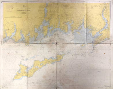
Sold2020Land Ho! Antique Fishers Island Sound, RI-CT-NY USCGDescription: Ahoy! Antique Coast Guard nautical chart of Fishers Island Sound, RI-CT-NY. Numbered C. & G. S. 358; published 1968. Material: paper. Measurement: approximate 36" x 45" (INCHES). ShippingSee Sold Price
Sold2023NAUTICAL CHART / CHESAPEAKE BAY COVE POINT TO SANDY POINTDescription: United States – East Coast Maryland. NAUTICAL CHART / CHESAPEAKE BAY COVE POINT TO SANDY POINT. Published at Washington D.C/ US Department of Commerce National Oceanic and AtmospheSee Sold Price
Sold2019Land Ho! Antique Western L.I. Sound, CT U.S. CoastDescription: Ahoy! Antique Coast Guard nautical chart of the L.I. Sound. Numbered C. & G. S. 1213; printed in 1968. Material: paper. Measurement: approximate 34" x 40" (INCHES). Shipping cost: $10; diSee Sold Price
Sold2019Land Ho! Antique Narragansett Bay, RI and MA U.S. CoastDescription: Ahoy! Antique Coast Guard nautical chart of the Narragansett Bay. Numbered C. & G. S. 353; with corrections from the Coast Guard denoted in purple. Material: paper. Measurement: approximaSee Sold Price
May 16Zikorn Arts & History ObjectsCentral America West Coast 1855 British Admiralty Nautical Chart$100(1 bid)
May 16Zikorn Arts & History ObjectsWest Indies, Providence, Windward, Cuba 1834 British Admiralty Map$100(1 bid)
May 16Zikorn Arts & History ObjectsEntrance to Baltic Great & Little Belt 1852 British Admiralty Map$100
5 days LeftJasper52Venezuela Coast Trinidad Tobago Isla Margarita ADMIRALTY chart 1894 (1950) map$120
5 days LeftJasper52Kingston approach Jamaica south coast Caribbean ADMIRALTY chart 1962 (1966) map$120
Featured5 days LeftJasper52Jamaica SE coast Morant-Portland Pt Kingston ADMIRALTY sea chart 1963 (1971) map$120
7 days LeftRail & Road AuctionsTwenty-Four Delta Air Lines Playing Card Decks - Travel Destination Advertising, Arizona, Jamaica,$50
5 days LeftJasper52West India Islands & Caribbean Sea Sheet 2 ADMIRALTY sea chart 1913 (1949) map$120
May 16Zikorn Arts & History ObjectsBosporus & Constantinople 1839 British Admiralty Nautical Chart$100


![A.D. Bache U.S. Coast Survey Charts East Coast: A. bis” A.D. Bache: [Upper Sheet] “Sketch A, Shewing the progress of the Survey in SECTION NO. 1, from 1852- 1861”. Scale 400,000. (to Passamaquoddy Bay) Published 1861. Measures 17.](https://p1.liveauctioneers.com/3731/160211/80894976_1_x.jpg?height=310&quality=70&version=1579814385)

![A.D. Bache U.S. Coast Survey Charts East Coast: “A. bis” A.D. Bache: [Lower Sheet] “Sketch A, Shewing the progress of the Survey in SECTION NO. 1, from 1844- 1861”. Scale 400,000. (to Passamaquoddy Bay) Published 1861. Measu](https://p1.liveauctioneers.com/3731/160211/80894977_1_x.jpg?height=310&quality=70&version=1579814385)