Sold2024Andrew Garran - Map of South Australia / Map of Northern Territory of South AustraliaLithographed maps originates from "Picturesque atlas of Australasia", 1st edition, published in Sidney 1886-88 by Andrew Garran. Size: 44 cm x 36,5 cm.See Sold Price
Sold2018Oceania. Western Australia. Tasmania. New Zealand.TITLE/CONTENT OF MAP: 'Oceania [inset: Western Australia. Tasmania. New Zealand]' DATE PRINTED: 1879 IMAGE SIZE: Approx 47.0 x 60.5cm, 18.5 x 24 inches (Large); Please note that this is a folding map.See Sold Price
Sold2017Homann Heirs, Charte van AsienHomann Heirs, Charte van Asien, Homann Heirs (18th c.), "Charte von Asien", c. 1793, hand-colored map of the continent including all of South East Asia and the northern tip of Australia, 20.5"h x 24.5See Sold Price
2023PETER LIK 'Lavender Sea' (2015) Nature Photography Acrylic Print'Lavender Sea' by Peter Lik, 2015 Based on the artist's stunning image of a lavender flower farm in Tasmania, Australia. 13.6 x 40.8 Inches 34.5 x 103.6 Centimeters Acrylic print on Fuji Silver CrystSee Sold Price
Sold2018Large Framed 1794 Map of America Laurie & Whittle1794, London New Map of America & The West India Islands. With detailed side maps of California, and Baffin & Hudson Bay. Published by Laurie and Whittle. Map measures approximately 43.5" L x 49.5" H,See Sold Price
Sold2023Hayley Lever (1876 - 1958) AmericanHayley Lever (1876 - 1958) Watercolor on Paper, Signed Lower Left, Measures ( 9.5 x 13.5 inches ) w/frame ( 20 x 24 inches )Born in Adelaide, Australia, Hayley Lever was known for his town-shore landsSee Sold Price
Sold2019Carte réduite des Terres Australes'. Pre-Cook AustraliaTITLE/CONTENT OF MAP: 'Carte réduite des Terres Australes [Reduced map of Terra Australis]' DATE PRINTED: 1753 IMAGE SIZE: Approx 21.5 x 29.0cm, 8.25 x 11.5 inches (Large); Please note that this is aSee Sold Price
Sold20231702 P. Lindstrom PA/DE Delaware Bay/RiverPeter Lindstrom (Lindestrom) Stockholm Sweden May of Pennsylvania, Delaware, Deleware River, & Bay 5 10 3/4 in Matt. From Philadelphia Print Shop. Lindstrom was mapping Swedish settlements in 1653. ItSee Sold Price
Sold2022SYDNEY, AUSTRALIA 5-NIGHT STAY W/ ACTIVITIES FOR 2128002 SYDNEY, AUSTRALIA 5-NIGHT STAY W/ ACTIVITIES FOR 2 Sydney, Australia deluxe 5-Star Swissotel 5-night stay in the heart of the city with daily breakfast for 2 and Winspire booking and conciergeSee Sold Price
Sold2022Italian Carved Wood Dolphin Foyer TableDESCRIPTION: An Italian carved figural dolphin table with gilt finish and round cut granite top. (Aisel 1 Left Bay 5) CIRCA: 20th Century ORIGIN: Italy DIMENSIONS: Approx: (Base) H: 28.5" x D: 34"(TopSee Sold Price
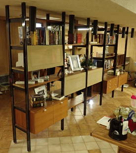
Sold20225 Bay Mid Century Wall Unit / System by Ladderax5 Bay Danish Modern Style Mid Century Modern Wall Unit / Record Cabinet by Ladderax - Consists of 6 Metal Sides, 1 Drop Down Record Box, 1 Cocktail Drop Down Box, 1 Drop Down Desk Box, 1 Chest Box andSee Sold Price
Sold20225 Bay Danish Modern "Sytem Cado" Wall System5 Bay Mid Century Modern "System Cado" Wall System - Poul Cadovius Consisting of Six 60 in Tall vertical wall brackets, 6 shelves, one chest box, One drop front record box, one drop front desk box, 2See Sold Price
Sold20235 Bay Mid Century Danish PS / Cado Style Wall Unit5 Bay Danish Mid Century Modern Teak Wall Unit / Wall System - Similar in design to PS Systems & Poul Cadovius ( Cado) shelving units, we are unable to positively identify this unit. Consists of 2 SliSee Sold Price
20191708 Cellarius Celestial Map from Northern HemisphereTitle: 1708 Cellarius Celestial Map from Northern Hemisphere -- Hemisphaerii Borealis Coeli et Terrae Sphaeri Cascenographia Date: 1708, Amsterdam Cartographer: A Cellarius Size: 16.8 X 19.1 in. AdditSee Sold Price
Sold202414 Rare Vintage Maps of Northern MN Lakes & Canada24" x 30" and smaller. Canadian Dep. of Mines & Resources 1939 map of Sioux Lookout, 1942 map of Quetico Ontario, 1939 map of Kenora Manitoba-Ontario, 1948 map of Ponite-Dubois Manitoba-Ontario, 1940See Sold Price
Sold20201761 MAP OF NORTH AMERICA BY ROCQUE18th century map GENERAL MAP OF NORTH AMERICA 1754-1761 by John Rocque, London by A. Drury, 2 part map, 35.5 x 36 inches, good condition.See Sold Price
Sold2018Early Herman Miller 5-Bay CSS Omni Wall UnitFrom the Estate of Joyce Dankoff. Herman Miller 5-Bay CSS Omni Wall Unit. Mid-Century.Designed by George Nelson. Maker's mark reads: "Designed By George Nelson Herman Miller Zeeland Mich.". 9 drawersSee Sold Price
Sold2016Map of North America...David H. Vance, engraved by J.H. Young. Philadelphia: Anthony Finley, 1825. Engraved map in 5 parts with original hand color in outline. 25 7/8 x 20 1/2 inches sheet, 30 5/8 x 25 1/2 inches framed.See Sold Price
Sold2020Japanese 6-Panel Screen Map, c. 19th CenturyA Japanese hand painted screen possibly depicting a map of bay regions in Japan. The piece is presented predominantly in shades of blue and brown with vibrant gilt detailing. The screen features six pSee Sold Price
Sold2022George Nelson "Omni" shelving systemGeorge Nelson "Omni" shelving system, 20th c., USA, configured as three metal wall mount modular units in copper finish, can be reassembled into single 5-bay system, with walnut shelves, Omni label toSee Sold Price
Sold2024Weller Pottery, Large Coppertone frog sprinklerWeller Pottery Large Coppertone frog sprinkler USA, c. 1930glazed earthenware, brass overall: 9.5 h x 10.75 w x 12 d in (24 x 27 x 30 cm) ceramic portion: 8.5 h x 10.75 w x 9.5 d in (22 x 27 x 24See Sold Price
Sold2022Southern School, 19th c.Southern School, 19th c., "Mobile Bay, Aug. 5, 1864", oil on canvas, unsigned, titled lower left, 10 in. x 14 in., framed. Provenance: Long Island Estate; Christie's, New York, Jan. 19, 2007, lot 324.See Sold Price
Sold2022"Coal Bunkers" Oil Painting - Roland WakelinItem/Description: Australian landscape with buildings. Coal Bunkers, Balls Head Bay, Australia. Signed and dated lower right: R. Wakelin '27. Titled on verso Roland Shakespeare Wakelin (Australia, NewSee Sold Price
Sold2017Doppelmayr/Homann: Northern Hemisphere Celestial MapTitle/Content of Map: 1742 Doppelmayr / Homann Celestial map of Northern Hemisphere -- Hemisphaerium Coeli Boreale in quo Fixarum Loca Secundum Eclipticae Ductum ad Anum 1730… Date Printed: 1742, NuSee Sold Price
Featured5 days LeftJasper52Americae Australis / Peruana by Bertius / Langenes. South America 1603 old map$280
Featured4 days LeftJasper521867 Beers Map of New York City Area -- Map of New York and Vicinity Accompanying "Atlas of New York$200
6 days LeftNY Elizabeth 1792 OLD INDIA HISTORY ANTIQUE ILLUSTRATED WITH MAPS OF THE EIGHTEENTH CENTURY IN FRENCH$50
6 days LeftJulien's AuctionsAC/DC | Bon Scott Australian "Gold" Record Award for "Let There Be Rock"$700(1 bid)
Jun 01RbfineartsHistorical Map of the Chesapeake Bay By Edwin Tunis Published By The National Brewing Co.$20(1 bid)
5 days LeftJulien's AuctionsThe Julian Lennon Collection | The Beatles "Hey Jude" RIAA "Gold" Single Record Award$2,500(1 bid)
5 days LeftJulien's AuctionsThe Julian Lennon Collection | The Beatles "I Feel Fine" RIAA "Gold" Single Record Award$1,000(1 bid)
5 days LeftJulien's AuctionsThe Julian Lennon Collection | The Beatles "Something" RIAA "Gold" Single Record Award$1,500
5 days LeftJulien's AuctionsThe Julian Lennon Collection | The Beatles "Nowhere Man" RIAA "Gold" Single Record Award$1,500(1 bid)
5 days LeftJulien's AuctionsThe Julian Lennon Collection | The Beatles "Yellow Submarine" Animation Cel$100
5 days LeftJulien's AuctionsThe Julian Lennon Collection | The Beatles Black and White Cut-Out Photo$100


![Oceania. Western Australia. Tasmania. New Zealand.: TITLE/CONTENT OF MAP: 'Oceania [inset: Western Australia. Tasmania. New Zealand]' DATE PRINTED: 1879 IMAGE SIZE: Approx 47.0 x 60.5cm, 18.5 x 24 inches (Large); Please note that this is a folding map.](https://p1.liveauctioneers.com/5584/120928/61572063_1_x.jpg?height=310&quality=70&version=1524615138)


![Carte réduite des Terres Australes'. Pre-Cook Australia: TITLE/CONTENT OF MAP: 'Carte réduite des Terres Australes [Reduced map of Terra Australis]' DATE PRINTED: 1753 IMAGE SIZE: Approx 21.5 x 29.0cm, 8.25 x 11.5 inches (Large); Please note that this is a](https://p1.liveauctioneers.com/5584/156033/78749910_1_x.jpg?height=310&quality=70&version=1575421548)