Sold2020Sanson Orbis Vetus World Map Paris 1657Nicolas Sanson (1600-1677), "Orbis Vetus, et Orbis Veteris Utraque Continens, Terrarumque Tractus Arcticus, et Antarcticus ex Platone, Thopompo, sive Aeliano, Manilio & c." Paris: P. Mariette, 1657. HSee Sold Price
Sold2020Framed Antique Map Orbis Vetus, Robert De VaugondyItem/Description: Old print. Map of the world by Robert de Vaugondy from 1752. Orbis vetus in utraque continente : In both the old continent / world map / Vaugondy 1752. Material: Print framed under gSee Sold Price
Sold2017Sanson: Antique Map of the Ancient World, 1679Map: Orbis Vetus, et Orbis Veteris Utraque Continens, Terrarumque Tractus Arcticus et Antarctibus Cartographer: Nicholas Sanson Place & Date: Paris / 1679 Size: 21 1/4" x 15" Condition: outline color;See Sold Price
Sold20211657 Sanson World Map with California as an Island --Title: 1657 Sanson World Map with California as an Island -- Orbis Vetus, et Orbis Veteris Utraque Continens, Terrarumque Tractus Arcticus, et AntarcticusÂ… Cartographer: N Sanson Year / Place: 165See Sold Price
Sold2019Gilles Robert de Vaugondy (1688-1766), "Orbis Vetus inGilles Robert de Vaugondy (1688-1766), "Orbis Vetus in Utraque Continente Juxta Mentem Sansoniam·distinctus, Redactus," 1752, Hemisphere map, hand colored, H.- 20 in., W.- 30 in.See Sold Price
Sold2022Antique Map of the World in Two HemispheresAntique Map of the World in Two Hemispheres - Orbis Vetus, Nicolas Sanson. Overall size: 19 1/2 x 25 1/2 in. Sight size: 15 x 21 in.See Sold Price
Sold2021After Henricus Hondius II (Dutch, 1597-1651)After Henricus Hondius II (Dutch, 1597-1651) , "Nova Totius Terrarum Orbis Geographica AC Hydrographica Tabula", later printing, hand-colored double-hemisphere map, exuberantly decorated with represenSee Sold Price
Sold2022Ortelius 16th Cent. ''Americae Siv Novi Orbis' MapAbraham Ortelius 16th Cent. ''Americae Siv Novi Orbis Nova Descriptio'' Map Engraving. Hand tinted Western Hemisphere map of America circa 1570-73, printed in Antwerp. Gallery framed with glass on botSee Sold Price
2017America Sive Nuvi Orbis MapAmerica Sive Nuvi Orbis. 22 x 17 in. Reproduction. Please note that this lot has a reserve. When you leave a bid in advance of the auction, submit your maximum. Jasper52 will bid on your behalf as mucSee Sold Price
Sold2017After Van Geelkercken, Orbis Terrarum MapAfter Nicholas (Nicolaes) van Geelkercken (Netherlandish, circa 1585-1656), "Orbis Terrarum Descriptio Duobis Planis Hemisphaeriis Comprehesa", hand colored world map on paper. Hand colored engravingSee Sold Price
Sold20161651 MAP BY PHILLIPPE DELA RUETERRA CHANAAN Ad Abrahami Tempora, Per Populos XI Item per Toparchias Idumeae totidem et Stationes XLV. Ad Mosis Tempora… [From “La Terre Sainte een Six Cartes Geographiques,†1651.]See Sold Price
Sold20191763 d'Anville Ancient World Map -- Orbis VeteribusTitle/Content of Map: 1763 d'Anville Ancient World Map -- Orbis Veteribus Notus Auspiciis Serenissimi Principis Ludovici Philippi Aurelianorum Ducis Publici Juris Factus Date: 1763, London CartographeSee Sold Price
Sold20221763 d'Anville Ancient World Map -- Orbis Veteribus Notus Auspiciis Serenissimi Principis LudoviciTitle: 1763 d'Anville Ancient World Map -- Orbis Veteribus Notus Auspiciis Serenissimi Principis Ludovici Philippi Aurelianorum Ducis Publici Juris Factus Cartographer: J d'Anville Year / Place: 1763,See Sold Price
Sold20191823 Lucas Handcolored Map Orbis Veteribus NotusMap of the Ancient world entitled “Orbis Veteribus Notus”, engraved at Baltimore by E. Lucas, Jr. 1823. Hand coloring, Fine condition, measures 14.5 x 11.5”. Reserve: $20.00 Shipping: Domestic:See Sold Price
Sold2024Nova Totius Terrarum Orbis Reproduction Map19" x 25". Framed modern reproduction of an antique world map depicting two sides of the globe flatly with colored illustrations around the edges. Minor wear, some marks and scratches to frame consistSee Sold Price
Sold2023Mercator, Rumold (1545-1599) World MapAn engraved double-page double hemispheric world map, "Orbis Terrae Compendiosa Descriptio". Dimensions:Sight is 11 1/4" x 20 3/4", the frame 21" x 29 1/2". Provenance:From a Philadelphia Collection.See Sold Price
Sold2024Nicolaes Van Geelkercken, 1632 world mapNicolaes Van Geelkercken, 1632 world map, Orbis Terrarum Descriptio Duobis Planis Hemisphaeriis Comprehesa, hand-colored engraving, 20th c. restrike, matted and framed under glass, 17"h x 23"w (sight)See Sold Price
Sold2018Two framed maps including Carte Du Golfe Du Mexique etTwo framed maps including Carte Du Golfe Du Mexique et Des Isles Antilles (sight size: 13" x 17") and Orbis Universal map of the world with plaque: David Rockefeller In appreciation for your tirelessSee Sold Price
Sold2019Nicolao Visscher. Orbis Terrum Nova MapNicolao Visscher (Dutch, 1618-1709). A hand-colored engraved map, circa 1658. Orbis Terrum Nova et Accuratussna Tabula. Showing partial coastlines of New Zealand and Australia. Unframed. 23-1/2 in x 2See Sold Price
Sold2022British Isles.- Ortelius (Abraham) Britannicarum Insularum Vetus Descriptio, two-sheet map ofBritish Isles.- Ortelius (Abraham) Britannicarum Insularum Vetus Descriptio, two-sheet map of ancient Britain, probably engraved by Jan Wierix, with four ornate strap-work cartouches, a naval battle iSee Sold Price
Sold2021Van Geelkercken Orbis Terrarum Engraved MapNicholas (Nicolaes) van Geelkercken (Netherlandish, circa 1585-1656), "Orbis Terrarum Descriptio Duobis Planis Hemisphaeriis Comprehesa," hand-colored engraving / engraved map on laid paper, depictingSee Sold Price
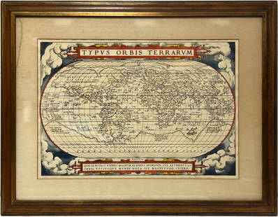
2023Early World Map "Typvs Orbis Terrarvm" Hand ColorDated 1590 near bottom legend box. Hand colored, with red and orange watercolor prominent in the titles. Blue clouds in border. Some slight use of yellow in the boundaries of the map. With signature oSee Sold Price
Sold20221651 Speed Map of the Holy Land -- Canaan. Begun by Mr. John More Continued and Finished by JohnTitle: 1651 Speed Map of the Holy Land -- Canaan. Begun by Mr. John More Continued and Finished by John Speede Cartographer: J Speed Year / Place: 1651, London Map Dimension (in.): 15.1 X 20.6 in. ThiSee Sold Price
6 days LeftFreeman's | Hindman[MAP]. ORTELIUS, Abraham. Americae Sive Novi Orbis, Nova Descriptio. 1573.$1,000(1 bid)
6 days LeftFreeman's | Hindman[MAP]. TODESCHI, Pietro. [Nova et Acurata Totius Americae Tabula auct. G.I. Blaeu] America quarta$5,000
3 days LeftJasper521630 EGYPT MAP copper engraving ANTIQUE from ENGLISH ED. Mercator-Hondius Atlas$35(1 bid)
3 days LeftJasper521784 Pomponius Mela CLASSICAL LATIN WORKS antique SCHOOL PRIZED VELLUM BINDING$200
BonhamsBLAEU (WILLEM AND JAN) Toonneel des Aerdrycz, oft Nieuwe Atlas... Tweede Deels, 2 parts in 1 vol...£8,000
BonhamsBLAEU (WILLEM AND JAN) Toonneel des Aerdrycks oft Nieuwe Atlas...Vierde Deel, Amsterdam, Jan Bla...£8,000
6 days LeftFreeman's | Hindman[MAPS]. ORTELIUS, Abraham. A group of 3 engraved maps with hand-coloring.$175(2 bids)
52 mins LeftTrillium Antique Prints & Rare BooksBraun & Hogenberg, pub. 1575 - View of Ostia, Italy$140(2 bids)
52 mins LeftTrillium Antique Prints & Rare BooksBraun & Hogenberg, pub. 1575 - Views in the Middle East: Aden, Mombasa, Kilwa, & Sofala$100(1 bid)
52 mins LeftTrillium Antique Prints & Rare BooksBraun & Hogenberg, pub. 1575 - View of Delft, Netherlands$100
52 mins LeftTrillium Antique Prints & Rare BooksBraun & Hogenberg, pub. 1575 - View of Alexandria, Egypt$100(1 bid)
52 mins LeftTrillium Antique Prints & Rare BooksBraun & Hogenberg, pub. 1575 - View of Chester, England$100
52 mins LeftTrillium Antique Prints & Rare BooksBraun & Hogenberg, pub. 1575 - View of Lyon, France$100
Jun 08Trillium Antique Prints & Rare BooksBraun & Hogenberg, pub. 1575 - View of Castle of Segeberg (Burg Segeberg) in Holstein, Germany$100
Jun 08Trillium Antique Prints & Rare BooksBraun & Hogenberg, pub. 1575 - View of Bristol, England$100
Jun 08Trillium Antique Prints & Rare BooksBraun & Hogenberg, pub. 1575 - View of Wroclaw (Breslau), Poland$100
Jun 08Trillium Antique Prints & Rare BooksBraun & Hogenberg, pub. 1575 - Views of Italy: Urbino and Sulmona$100


![1651 MAP BY PHILLIPPE DELA RUE: TERRA CHANAAN Ad Abrahami Tempora, Per Populos XI Item per Toparchias Idumeae totidem et Stationes XLV. Ad Mosis Tempora… [From “La Terre Sainte een Six Cartes Geographiques,†1651.]](https://p1.liveauctioneers.com/1325/87507/44874086_1_x.jpg?height=310&quality=70&version=1460509601)


![[MAP]. ORTELIUS, Abraham. Americae Sive Novi Orbis, Nova Descriptio. 1573. (1 of 2)](https://p1.liveauctioneers.com/197/329395/177650534_1_x.jpg?height=282&quality=70&version=1715364962)
![[MAP]. TODESCHI, Pietro. [Nova et Acurata Totius Americae Tabula auct. G.I. Blaeu] America quarta (1 of 1)](https://p1.liveauctioneers.com/197/329395/177650542_1_x.jpg?height=282&quality=70&version=1715364962)


![[MAPS]. ORTELIUS, Abraham. A group of 3 engraved maps with hand-coloring. (1 of 4)](https://p1.liveauctioneers.com/197/329395/177650539_1_x.jpg?height=282&quality=70&version=1715364962)


