Sold2017Ettling: Map of United States of North America, 1860United States of North America (Eastern & Central) T. J. Ettling, c1860 17 x 25. This great Civil War era map covers the country from the Rocky Mountains to the Atlantic seaboard. The map is engravedSee Sold Price
Sold2022Antique Civil War Era County Map of Kentucky and Tennessee by by S. Augustus Mitchell, Jr., 1860Antique Civil War Era Map of Kentucky and Tennessee by by S. Augustus Mitchell, Jr., 1860 | Full Title: Map of North America Showing Its Political Divisions, and Recent Discoveries in the Polar RegionSee Sold Price
Sold2017Mitchell: Antique Map of North America, 1860Map of North America Showing Its Political Divisions and Recent Discoveries in the Polar Regions. This is the 1860 pre-Civil War plate, but was published in 1866 by Mitchell in his New General Atlas.See Sold Price
Sold2022Antique Civil War Era Map of North American by by S. Augustus Mitchell, Jr., 1860Antique Civil War Era Map of North American by by S. Augustus Mitchell, Jr., 1860 | Full Title: Map of North America Showing Its Political Divisions, and Recent Discoveries in the Polar Regions | ConsSee Sold Price
Sold2023Civil War era map of North America from S. A. Mitchell Jr.Wonderful map of the North American continent with 1860 date but published in the 1863 Mitchell New General Atlas. Shows the United States at the height of the Civil War. Depicts the North American coSee Sold Price
Sold2022AN AMERICAN CIVIL WAR ERA MAP, "United States of North America (Eastern & Central)," LONDON,AN AMERICAN CIVIL WAR ERA MAP, "United States of North America (Eastern & Central)," LONDON, 1861-1873, THEODORE ETTLING (b. 1823), hand colored lithograph on paper, by T. Ettling, published by CasselSee Sold Price
Sold2018Two Civil War Era Mitchell MapsMap of North America Showing Its Political Divisions and county maps of North Carolina, South Carolina, and Florida on one sheet (Philadelphia: S. Augustus Mitchell, 1860). Not framed. 15.25 x 12.25 iSee Sold Price
Sold2017Bien: Antique Map of the US, Union & Confederate, 1895Item: Map of the United States of America showing the boundaries of the Union and Confederate geographical divisions and departments, Dec. 31, 1860 Maker: Julius Bien & Co Size: 28 x 17 inches Date: 1See Sold Price
Sold2017Blakie: Antique Map of North America, 1860Map: 1860 Blakie Map of North America -- North America Cartographer: W Blackie and Son Year / Place: 1860, London, Glasgow Dimensions: 14.5 x 12.2 in. Condition: Very Good. Nice impression and excelleSee Sold Price
Sold2023Early Civil War Map of North AmericaEntitled Supplement to the Illustrated London News, July 1, 1861, Stephenson colortoned to show the Union states and Seceded or Rebel states. Full title being: Map of the United States of America, UppSee Sold Price
Sold2017Fullarton: Antique Map of North America, 1860Map: 1860 Fullarton Map of North America -- North America Cartographer: A Fullarton & Co. Year / Place: 1860 c., Edinburgh Map Dimensions: 18.5 x 16 in. Condition: Very good. Nice pastel colors. ModesSee Sold Price
Sold20191858 Mitchell Map of North America -- No 4 Map of NorthTitle/Content of Map: 1858 Mitchell Map of North America -- No 4 Map of North America Date: 1858, PhiladelphiaCartographer: S Mitchell Size: 10.4 X 8.2 in. A nice pre-Civil War map of North America, fSee Sold Price
Sold2024Rapkin, John 1860 Antique Map. North America. USA CanadaSteel Engraved Map Published 1860 by The London Printing & Published Company, London for "The Royal Dictionary-Cyclopedia for Universal Reference" by Thomas Wright. Drawn & Engraved by John Rapkin. FoSee Sold Price
2018Ettling: Antique Map of USA SOUTH EAST, 1863TITLE/CONTENT OF MAP: 'United States of North America (Eastern & central)' USA SOUTH EAST. Florida Georgia Carolina coast Bahamas DATE PRINTED: 1863 IMAGE SIZE: Approx 44.5 x 32.0cm, 17.5 x 12.5 incheSee Sold Price
Sold2024Civil War era map of N. America with unsettled state bordersOne of the key maps in the 1860s Johnson series of North America. In this map Idaho Territory encompasses what would eventually become Idaho, Montana and Wyoming. Dakota Territory has yet to split intSee Sold Price
Sold2023Civil War era map of N. America with unsettled state bordersOne of the key maps in the 1860s Johnson series of North America. In this map Dakota Territory has yet to split into its north and south divisions while it stretches to encompass what will eventuallySee Sold Price
Sold2022Civil War era map of N. America with unsettled state bordersOne of the key maps in the 1860s Johnson series of North America. In this map Idaho Territory encompasses what would eventually become Idaho, Montana and Wyoming. Dakota Territory has yet to split intSee Sold Price
Sold2020Early Civil War era map of AmericaNice example of A. J. Johnson's 1862 map of North America. Presents a fascinating snapshot of North America just after the outbreak of the American Civil War. States generally follow the 1861 configurSee Sold Price
Sold2017Mitchell: Antique Map of North America, 1864Title: Map of North America by Mitchell Date: 1864 Dimensions (inches): 12 x 15 Medium: Hand Colored Lithograph Good Condition, little bit of foxing Samuel Augustus Mitchell (1790-1860) was an AmericaSee Sold Price
Sold2018Ettling: Antique Map of USA NORTH EAST, 1863TITLE/CONTENT OF MAP: 'United States of North America North Eastern sheet' New England & Mid-Atlantic states. DATE PRINTED: 1863 IMAGE SIZE: Approx 45.5 x 33.0cm, 17.75 x 13 inches (Large) TYPE: AntiqSee Sold Price
Sold2020CIVIL WAR USA showing Union Confederate & BorderTITLE/CONTENT OF MAP: 'United States of North America (Eastern & central)' The map depicts the United States as divided in the early part of the Civil War between the Union states, the Confederate staSee Sold Price
Sold2017Johnson: Antique 1st Edition Civil War Military Map1st edition Johnson’s Civil War Military Map, Johnson & Browning. Scarce 1861 map by A. J. Johnson showing the military deportment of the United States in 1860, just before war broke out in the statSee Sold Price
Sold2024Unusual 1860 map of Virginia and N. Carolina during the Civil WarA very detailed view of the states as they existed when the country was engaged in the Civil War. An unusual map because North Carolina is rarely seen in conjunction with Virginia in American atlas maSee Sold Price
Sold20214 Antique MapsIncludes McNally's System of Geography map of NJ, PA, DE, & MD drawn by J. Wells, 1860 map of North America by S. Augustus Mitchell, Jr, Denver News Co. US. Map, and 1924 map of Los Angeles. Los AngelSee Sold Price
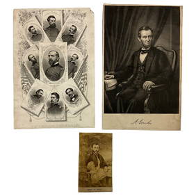
3 days LeftLakeshore Event CenterEphemera, Civil War Generals, Abraham Lincoln, Ulysses Grant, Lot of 3$62(2 bids)
Jul 04Weatherham Estate TreasuresAbraham Lincoln Bronze Bust Sculpture On Marble Base - Signed Original - 10lbs$400
4 days LeftSchilb Antiquarian Rare Books1918 Robert E Lee Civil WAR Confederate General CSA Battles MAPS Illustrated$48(5 bids)
Jul 07Case Antiques, Inc. Auctions & Appraisals3 Civil War Era Photos, incl. Rose O'Neal Greenhow, poss. Jeff Davis$150
Jun 26University ArchivesAbraham Lincoln PSA GEM MT 10 CDV, Signed 3 Weeks Before His Death.$30,000(1 bid)
4 days LeftSchilb Antiquarian Rare Books1890 1ed Confederate Memoirs of Joseph Johnston & Jefferson Davis Civil War CSA$66(3 bids)
Jun 26University ArchivesCapture of Jefferson Davis: “Mr. Davis tried to escape…with a ladies waterproof$1,600
Jul 14Schilb Antiquarian Rare Books1928 Life of Abraham Lincoln 1ed SLAVERY Civil War Albert Beveridge 2v SET$1(1 bid)
4 days LeftSchilb Antiquarian Rare Books1860 Political Textbook 1ed SLAVERY Abe Lincoln Douglass Civil War Government$74(4 bids)
Jul 14Schilb Antiquarian Rare Books1885 Civil War 1ed Memoirs of Union General Ulysses S. Grant Illustrated MAPS 2v$125(6 bids)
Jul 06Case Antiques, Inc. Auctions & AppraisalsCivil War Veteran GAR Uniform, PVT Stephen F. Oliver$200(1 bid)
Jul 06Case Antiques, Inc. Auctions & Appraisals7 Stephens and Davis CSA Items inc. ALS, Bust, CDVs and Seals$150(1 bid)
4 days LeftMynt AuctionsMort Kunstler Civil War Print Robert E Lee at Fredericksburg Custom Framed$10
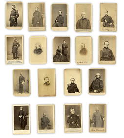
Jun 26University Archives18 pc. CDV Archive of Civil War Generals Incl. Many Brady & E. Anthony Examples$260(1 bid)