2023Early World Map "Typvs Orbis Terrarvm" Hand ColorDated 1590 near bottom legend box. Hand colored, with red and orange watercolor prominent in the titles. Blue clouds in border. Some slight use of yellow in the boundaries of the map. With signature oSee Sold Price
Sold2017Early World Maps Paul 'Marco Polo' Castaldo 1683Early World Maps Paul 'Marco Polo' Castaldo (gastaldi) Lopez (lopes) Mallet 1683. Title of the Map: 'carte Du Monde De Marc Paul; Carte Du Monde De Jacques Castaldo; Carte Du Monde De Miguel Lopez' twSee Sold Price
Sold2017Framed Colored Engraved 17th C. World Map"Nova Totius Terrarum Sive Novi Orbis Tabula" Framed Colored Engraved 17th C. World Map by Willem Janszoon Blaeu - This interesting piece is an early world map created by Willem Janszoon Blaeu. The maSee Sold Price
Sold2019Early 1900s World Map of French Colonies -- LigueTitle: Early 1900s World Map of French Colonies -- Ligue Maritime et Coloniale Francaise Date: early 1900s Cartographer: Reconnue d'Utilite Publique Size: 29.5 X 44.5 in. Additional Information: ThisSee Sold Price
Sold2022World.- Bordone (Benedetto di) [World Map], woodcut, [1522].World.- Bordone (Benedetto di) [World Map], early map showing the recent developments in cartography and departing from Ptolemaic models, including open water between the two continents and not joininSee Sold Price
Sold2016CARTOGRAPHY HISTORY REFERENCE VOLUMECARTOGRAPHY HISTORY REFERENCE VOLUME, Rodney W. Shirley, "The Mapping of the World: Early Printed World Maps, 1472-1700", 1983, Holland Press, London, printed as "Volume 9 in the Holland Press CartogrSee Sold Price
Sold2022(BRITISH EMPIRE.) George Philip & Son, Ltd.; and The London Geographical Institute. Navy League Map(BRITISH EMPIRE.) George Philip & Son, Ltd.; and The London Geographical Institute. Navy League Map of the British Empire. Oversize chromolithograph map of the world delineating early 20th-century BriSee Sold Price
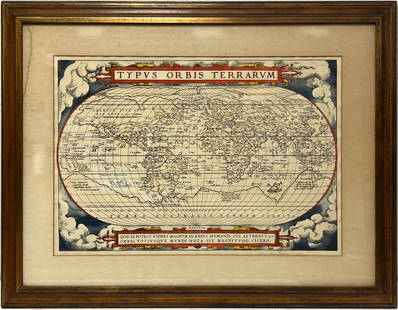
Sold2018ANTIQUE HAND COLORED WORLD MAP WITH SCENIC CORNERS.ANTIQUE HAND COLORED WORLD MAP WITH SCENIC CORNERS ON EARLY LAID PAPER. IMAGE 22 3/4 X 19 1/4See Sold Price
Sold2023Two Maps, Africa by Eustache Herisson, 1809, World Hemispheres 1832 Reprint after A.H Brue, GermanDescription: An antique Africa map, in French and dated 1809 by Eustache Herisson, and a reprit of an early 19th century map of World Hemispheres by Adrien-Hubert Brue. Type: MapMaterials: PaperMarkinSee Sold Price
Sold20212 Pyrography Leather MapsTwo Pyrography Leather Maps, in scroll form with wood rod ends, both with pyrography and polychromed designs, includes: world and regional maps, early 20th C, 21" x 16", 21" x 18". CONDITION: Modest wSee Sold Price
Sold2022c 1780 Map of The World Liverpool Creamware BowlGlass and Porcelain "The WORLD in PLANISPHERE." World Map Transfer Large 13.5" Historic Liverpool Creamware Titled Bowl c. 1780-1800 Revolutionary War Period to Federal Period, Historical Liverpool CrSee Sold Price
Sold2016c. 1760s, Hand-Colored World Map, “Mappa Mondo”Historic Maps 1760 Hand-Colored World Map, Siena Presso Pazzini Carli c. 1760s, Hand-Colored World Map, “Mappa Mondo,” Printed & Colored by Siena Presso Pazzini Carli, Choice Very Fine. A fine GobSee Sold Price
Sold2021Authentic Early / 18th C Maps(1) South America Bolivia and Peru Sheet VI Engraved by J. and C. Walker; (2) Rand McNally and Co Atlas of the World Map of Bolivia, Ecuador and Peru page 173; (3) Andre Sculpt's Imperii Romani DistraSee Sold Price
Sold20231810 Modern Geography America MAP + World Map Massachusetts Elijah Parish1810 Modern Geography America MAP + World Map Massachusetts Elijah Parish Elijah Parishs “New System of Modern Geography” is an early 19th-century American geography textbook. Published inSee Sold Price
Sold2022Scarce 1855 Minnesota from Colton’s Atlas of the WorldImportant early atlas map of Minnesota Territory, immediately after the creation of Dakota Territory. This map appeared in the 1856 Colton 2-volume Atlas of the World. Map is by Johnson & Browning. ItSee Sold Price
Sold2023Scarce early McNally map of Georgia - 1881Early and scarce 1881 Rand McNally Indexed Atlas of the World map of Georgia. Highly detailed, showing counties, towns, rivers, mountains, lakes, roads, railroads, stations, swamps, topography, etc. PSee Sold Price
Sold2018Early 19th century School Girl Embroidery of OldEarly 19th century School Girl Embroidery of Old World-New world maps surrounded by floral garland decoration. Loss to silk and embroidery. Framed. Overall size: 21" x 29".See Sold Price
Sold2022Two Tiffany & Co. sterling silver cigarette boxesLate 20th/early 21st century Each marked for Tiffany & Co. sterling; further marked: Made in Italy Each box with wood lined interior, comprising one with an etched world map design and one with an iSee Sold Price
Sold20221846 Pictorial View of the World, by Phelps, NYHistoric Maps "Pictorial View of the World 1846" Map by Phelps 1846-Dated, Hand-Colored Printed Broadside Poster, "Pictorial View of the World. - 1846" With a Map of the World, Showing a List of "DistSee Sold Price
Sold2015Lg Framed early 19th c. Map of the WorldLg Framed early 19th c. Map of the World, "Mappe Monde", Indication des trois voyages du Capitaine Cook, French 1816 in floral gilt 32" x 46" frame Condition; was folded, some wear along fold lines frSee Sold Price
Sold2023Book Collection, Early Maps Of The Americas (10pc)(1) "America: Early Maps of the New World" Edited by Hans Wolff (Munich: Prestel. 1992), Folio, hardcover with dj, 192pp; (1) "The Mapping of New Spain: Indigenous Cartography and the Maps of the RelaSee Sold Price
Sold20211830 "A New Atlas World" Educational School Map Book1830 "A New Atlas World"Antique Educational School Maps. This is a wonderful antique atlas for early education, geography classes. It has a layout of the world and the breakdown of each continent. BecSee Sold Price
Sold201918th C Map Ancient World JerusalemEngraved plate showing maps of ancient world including inset of Judea and Samaria and one of Jerusalem. Early 18th century.Very Good, trimmed to plate lines, measures 7 x 5.5". Reserve: $20.00 ShippinSee Sold Price
May 14Akiba Galleries(2 Pc) Allain Manesson Mallet Description De L'Univers 2 Vol. German Translation$200(1 bid)
2 days LeftJasper52Coastline of Cape Blanco, Patagonia, Argentina by Pirate G. Anson (1756)$20(1 bid)
7 days LeftSchilb Antiquarian Rare Books1977 JRR Tolkien 1st ed 1st Printing Silmarillion Lord of the Rings + MAP + DJ$200(5 bids)
2 days LeftJasper521753 Prevost Map of Pacific Wind Currents -- Representation du Cours ordinaire des Vents de Traverse$85
Jun 02Schilb Antiquarian Rare Books1897 History of British Empire England Scotland Canada James II MAPS India 6v$1
6 days LeftTrillium Antique Prints & Rare BooksBraun & Hogenberg, pub. 1575 - View of Bologna, Italy$100(1 bid)
6 days LeftTrillium Antique Prints & Rare BooksBraun & Hogenberg, pub. 1575 - View of Basel, Switzerland$100
6 days LeftTrillium Antique Prints & Rare BooksBraun & Hogenberg, pub. 1575 - View of Marseille, France$100
6 days LeftTrillium Antique Prints & Rare BooksBraun & Hogenberg, pub. 1575 - View of Limbourg, Belgium$100
6 days LeftTrillium Antique Prints & Rare BooksBraun & Hogenberg, pub. 1575 - Coats of arms of Hannonia, Hennegau in Belgium$100
6 days LeftTrillium Antique Prints & Rare BooksBraun & Hogenberg, pub. 1575 - View of Haarlem, Netherlands$100
May 16Potter & Potter AuctionsMap to Acquaint You with the Great Mission Bay Project. 194...$125(1 bid)


![World.- Bordone (Benedetto di) [World Map], woodcut, [1522].: World.- Bordone (Benedetto di) [World Map], early map showing the recent developments in cartography and departing from Ptolemaic models, including open water between the two continents and not joinin](https://p1.liveauctioneers.com/5458/252576/131355887_1_x.jpg?height=310&quality=70&version=1655911671)


