Sold2022(AMERICAN SOUTHEAST.) Herman Moll. Carolina.(AMERICAN SOUTHEAST.) Herman Moll. Carolina. Engraved map of colonial North America from St. Augustine to the Chesapeake Bay. 8½x12 inches sheet size, ample margins; minor closure at upper edge,See Sold Price
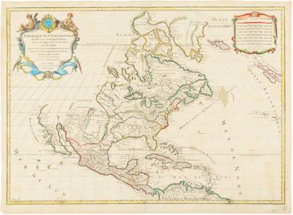
Sold2024Herman Moll A New Map of Ye North Parts of AmericaHerman Moll (British, 1654-1732). Colored engraved map, A New Map of Ye North Parts of America Claimed by France Under Ye Names of Louisiana, Mississipi [sic], Canada & New France, With the AdjoiningSee Sold Price
Sold2023AMERICA H. Moll Geographer 1732 MapHerman Moll 1732 Map of the Americas, North and South America with California depicted as an island. Hand Colored engraving 8 1/2 x 11 in Matt.See Sold Price
Sold2022MOLL, HERMAN. A New Map of the North Parts of America claimed by France under ye Names of Louisiana,MOLL, HERMAN. A New Map of the North Parts of America claimed by France under ye Names of Louisiana, Mississipi, Canada and New France with ye Adjoyning Territories of England and Spain. Large engraveSee Sold Price
Sold2021Collection of Antique Maps of North AmericaA framed collection of nine small maps including "The English Empire in America, Newfound-Land, Canada, Hudsons Bay &c. in Plano" by Herman Moll circa 1709 and "North America from the Best AuthoritiesSee Sold Price
Sold2022MOLL, HERMAN. [The World Described].MOLL, HERMAN. [The World Described]. 18 engraved multiple-sheet folding maps with original outline hand-color (i.e., incomplete; no beaver map, no codfish map). Tall folio, 25x12 inches, period calf bSee Sold Price
Sold2024Map of the North Parts of America Claimed by France by Herman Moll (London, 1720)Map of the North Parts of America Claimed by France by Herman Moll (London, 1720) "A New Map of the North Parts of America claimed by France under ye Names of Louisiana, Mississippi, Canada, and New FSee Sold Price
Sold2021MOLL, HERMAN. America.MOLL, HERMAN. America. Engraved folding map of North and South America showing trade winds and California as an island. 16x10 inches sheet size, wide margins; minor edge stains but overall nice. EarlySee Sold Price
Sold2022BEAVER MAP, HERMAN MOLL (DUTCH/BRITISH, 1654-1732)A New and Exact Map of the Dominions of the King of Great Britain on ye Continent of North America containing Newfoundland, New Scotland, New England, New York, New Jersey, Pensilvania, Maryland, VirgSee Sold Price
Sold2020MOLL, HERMAN. A Map of New France Containing Canada,MOLL, HERMAN. A Map of New France Containing Canada, Louisiana &c. in Nth America. Hand-colored engraved map of colonial North America. 7¾x10¾ inches sheet size, ample margins; mounted to foSee Sold Price
Sold2022(AMERICAS.) Herman Moll. A Map of America According to ye Newest and Most Exact Observations.(AMERICAS.) Herman Moll. A Map of America According to ye Newest and Most Exact Observations. Engraved map of North and South America showing California as an island. 11½x7¾ inches sheet sizSee Sold Price
Sold20241st ed. of Moll’s fascinating 1701 map of Isle of CaliforniaHerman Moll's renowned and highly sought-after map showing California as an island, plus the western part of North America. This is the first appearance of this map, with page number 152 clearly shownSee Sold Price
Sold2018Caribbean & Gulf of Mexico.- Moll (Herman) A Map of theCaribbean & Gulf of Mexico.- Moll (Herman) A Map of the West-Indies or the Islands of America in the North Sea, a large and impressively detailed chart, showing parts of Louisiana and Florida in trianSee Sold Price
Sold2015Moll (Herman) - Virginia and Maryland,the Chesapeake Bay area, engraved map with original hand-colouring in outline, 275 x 210mm., 1729; with A Map of the British and French Plantations in North America, covering New England, Nova Scotia,See Sold Price
Sold2017Herman Moll: Map of North Part of Turkey in Europe 1726Herman Moll, The North Part of Turkey in Europe, Slovonia &c. 1726. The Balkans: An original anitque map of northern Greece and the Balkan countries including Croatia, Serbia, Bulgaria and Romania amoSee Sold Price
Sold20241719 Map of Colonial era North America, by Sanson - JaillotTitle: 1719 Map of Colonial era North America, by Sanson - Jaillot Date/Period: 1719 Materials: Copperplate engraved Size: 25 1/2 x 18” This map is a rare and valuable map of history, showing NoSee Sold Price
Sold2020Jacques Chiquet North America Map 1719 CaliforniaJacques Chiquet (1673-1721), "L'Amerique Septentrionale qui fait partie des Indes Occidentales," Paris, 1719. This excellent hand colored map of North America includes a depiction of California as anSee Sold Price
Sold2017Moll / Oldmixon: Antique Map of North America, 1721Map: Nieuwe Kaart van Noord Amerika Cartographer: H. Moll / Oldmixon Place & Date: Amsterdam / 1721 Size: 9 3/4" x 6 3/4" Condition: outline color; overall age toning and minor spotting In this DutchSee Sold Price
Sold2017FRAMED WORLD MAP BY HERMAN MOLL, 1719'A New & Correct Map of the Whole World, by Herman Moll, Geographer, 1719.' Hand tinted and framed. Frame size: 73 x 124 cm (28 3/4 x 48 3/4 in.)See Sold Price
Sold2023HERMAN MOLL (ENGLISH, C. 1654-1732) MAP OF NORTH AND SOUTH CAROLINAHERMAN MOLL (ENGLISH, C. 1654-1732) MAP OF NORTH AND SOUTH CAROLINA, hand-colored engraving on laid paper, titled "CAROLINA / By / H. Moll Geographer" in a rectangular cartouche along lSee Sold Price
Sold2015Map of North America 1719Heading: (North America) Author: Sanson, Nicolas/ Hubert Jaillot Title: Amerique Septentrionale divisée en ses Principales Parties, ou sont distingués les uns des autres les Estats suivant quils appSee Sold Price
Sold2016America by Herman Moll 1716Map Title: America, According to the Newest and Most Exact Observations Maker: Herman Moll Date: 1716 Origin: Atlas Geographicus Size: 13 x 16 inches Medium: Copperplate engraving Herman Moll (1654-17See Sold Price
Sold2020John Senex Map of North and South America 1719-17John Senex (1678–1740), "A New Map of America from the Latest Observations," London, ca. 1719-1721. Hand colored copperplate engraved map of North and South America, from Senex's "New General ASee Sold Price
Sold2021Framed Contemporary Fish Chart & Adirondack MapTrout, Salmon & Char of North America measures 25" x 40". Adirondack Map Northville-Placid Trail #33/50 measures 25" x 37".See Sold Price
10 hrs LeftTrillium Antique Prints & Rare BooksSanson - Map of Florida (encompassing most of Southeast North America)$130(2 bids)
6 days LeftFreeman's | HindmanHOMANN, Johann Baptist. Amplissimae Regionis Mississipi Seu Provinciae Ludovicianae. Nuremburg, [ca$425(2 bids)
10 hrs LeftTrillium Antique Prints & Rare BooksKohler & Weigel - Map of the World with North and South Pole views$150(2 bids)
10 hrs LeftTrillium Antique Prints & Rare BooksCollot's A Journey in North America - Atlas Volume with 36 Maps$200(1 bid)
6 days LeftFreeman's | HindmanHARMON, Daniel Williams. A Journal of Voyages and Travels in the Interiour of North America. 1820.$450(2 bids)
Jun 23Schilb Antiquarian Rare Books1860 Voyages of Jonathan Carver INDIANS North America Mississippi Natchez Tours$1(1 bid)


![Herman Moll A New Map of Ye North Parts of America: Herman Moll (British, 1654-1732). Colored engraved map, A New Map of Ye North Parts of America Claimed by France Under Ye Names of Louisiana, Mississipi [sic], Canada & New France, With the Adjoining](https://p1.liveauctioneers.com/7691/320359/172153415_1_x.jpg?height=310&quality=70&version=1708543789)


![MOLL, HERMAN. [The World Described].: MOLL, HERMAN. [The World Described]. 18 engraved multiple-sheet folding maps with original outline hand-color (i.e., incomplete; no beaver map, no codfish map). Tall folio, 25x12 inches, period calf b](https://p1.liveauctioneers.com/199/251723/130782476_1_x.jpg?height=310&quality=70&version=1655133895)