Sold2021Guthrie, William 1806 Map. GermanyCopper Engraved Map Published 1806, London for "A New Geographical, Historical and Commercial Grammar..." by William Guthrie. The maps are by John Senex, Thomas Kitchin and others. Folds as issued. PaSee Sold Price
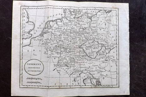
Sold2021Guthrie, William 1798 Map. GermanyCopper Engraved Map Published 1798, London for "A New Geographical, Historical and Commercial Grammar..." by William Guthrie. The maps are by John Senex, Thomas Kitchin and others. Folds as issued. PaSee Sold Price
Sold2021Guthrie, William 1798 Map. GermanyCopper Engraved Map Published 1798, London for "A New Geographical, Historical and Commercial Grammar..." by William Guthrie. The maps are by John Senex, Thomas Kitchin and others. Folds as issued. PaSee Sold Price
Sold2021Barlow 1807 Antique Map. GermanyCopper Engraved Map Published 1807 by Brightly & Kinnersley, Bungay, England for "A General View of the World, Geographical, Historical and Philosophical" by The Rev. E. Blomfield. Engraved by Barlow.See Sold Price
Sold2022Guthrie & Kitchin 1782 Map. GermanyCopper Engraved Map Published 1782, London for "A New Geographical, Historical and Commercial Grammar..." by William Guthrie. The maps are by John Senex, Thomas Kitchin and others. Folds as issued. PaSee Sold Price
Sold2022LUFTWAFFE FLIGHT MAP OF GERMANY, FRANCE AND ENGLANDDouble-sided ‘Luft-Navigationskarte’ (‘Air Navigation Map’), 26.5 x 24 in., printed on weatherproofed canvas and produced by the General Staff of the Luftwaffe, circa 1941. BSee Sold Price
Sold2023Exquisite vertical format vintage map of Germany – 1865Beautiful and large two-page map of Germany in an unusual vertical format. Covers the region from the Baltic Sea to the Adriatic Sea. This historical document shows the two great regions of Germany, PSee Sold Price
Sold2021Kitchin, Thomas 1785 Map of Germany & Netherlands"Germany with the Seven United Provinces" Copper Engraved Map Published 1783-85, London for "A New Geographical, Historical and Commercial Grammar..." by William Guthrie. Drawn and Engraved by ThomasSee Sold Price
Sold2021Barlow 1807 Antique Map of GermanyCopper Engraved Map Published 1807 by Brightly & Kinnersley, Bungay, England for "A General View of the World, Geographical, Historical and Philosophical" by The Rev. E. Blomfield. Maps Engraved by BaSee Sold Price
Sold2022Lizars, Daniel 1831 LG Rare HC Map. Franconia, GermanyLarge Folio Copper Engraved Map Published 1831-2 by John Hamilton, Successor to Daniel Lizars, Edinburgh for "The Edinburgh Geographical and Historical Atlas..." First Edition by Daniel Lizars. Very fSee Sold Price
Sold2023Lizars, Daniel 1831 LG Rare HC Map. Franconia, GermanyLarge Folio Copper Engraved Map Published 1831-2 by John Hamilton, Successor to Daniel Lizars, Edinburgh for "The Edinburgh Geographical and Historical Atlas..." First Edition by Daniel Lizars. Very fSee Sold Price
Sold2022Lizars, Daniel 1831 LG Rare HC Map. Upper Saxony, GermanyLarge Folio Copper Engraved Map Published 1831-2 by John Hamilton, Successor to Daniel Lizars, Edinburgh for "The Edinburgh Geographical and Historical Atlas..." First Edition by Daniel Lizars. Very fSee Sold Price
Sold2023Lizars, Daniel 1831 LG Rare HC Map. Upper Saxony, GermanyLarge Folio Copper Engraved Map Published 1831-2 by John Hamilton, Successor to Daniel Lizars, Edinburgh for "The Edinburgh Geographical and Historical Atlas..." First Edition by Daniel Lizars. Very fSee Sold Price
Sold2023Antique Map Print - Europe - Map of Silesia - Poland - Czech Republic - WroclawDescription: Map of Silesia. Silesia is a historical region of Central Europe that lies mostly within Poland, with small parts in the Czech Republic and Germany. Date: 17th Century Material: Paper DimSee Sold Price
Sold2019Barlow 1807 Group of 3 European MapsIncl Germany, Switzerland, and France. Copper Engraved Maps Published 1807 by Brightly & Kinnersley, Bungay, England for "A General View of the World, Geographical, Historical and Philosophical" by ThSee Sold Price
Sold2022Salmon & Jeffreys 1749 Lot of 3 Maps with faultsIncl Germany, Hungary/Turkey, and England/Wales. Copper Engraved Map Published 1749, London for "A New Geographical and Historical Grammar" First or Early Edition by Thomas Salmon. Engraved by ThomasSee Sold Price
Sold2021London 1800 Stockdale's Geography with MapsA Geographical, Historical and Political Description of … Germany, Holland, The Netherlands, Switzerland, Prussia, Italy, Sicily, Corsica & Sardinia. London: John Stockdale, 1800. Large 4to -- 10 xSee Sold Price
Sold2020Original Historical Map of Nantucket By E.K. GodfreyOriginal Historical Map of Nantucket By E.K. Godfrey, 1882,"New Map of the Streets of Nantucket Mass.", with Location of Public Buildings and Places of Interest, copyright, 1882 By E.K. Godfrey, matteSee Sold Price
Sold202318th C Antique Historical Map Of Montreal Quebec1758 Antique Historical Hand Tinted Map Of Montreal, Titled Plan of the Town and Fortifications of Montreal or Ville Marie in Canada. Map measures 7 inches H x 10 W within matting, framed 14.5 inchesSee Sold Price
Sold2022Huge 1876 Historical Map of the U.S. by BlanchardHistoric Maps 1876 "Historical Map of the United States Showing Early Spanish, French & English Discoveries and Explorations, also Forts, Towns & Battlefields of Historic Interest" by Rufus BlanchardSee Sold Price
Sold2023An important historical map by Montanus and Ogilby depicting New York, New England, and Virginia,An important historical map by Montanus and Ogilby depicting New York, New England, and Virginia, published in 1671. This map from a Jansson-Visscher map of the Northeast, extending from the St. LaureSee Sold Price
Sold2018Group of New York State Historical MapsGroup of New York State Historical Maps. Map of Orleans County, NY, 1852 (40" x 47"); Map of Village of Albion, NY, 1857 (40" x 47"); Map of the State of New York, 1833 (21" x 25 1/2").. The RochesterSee Sold Price
Sold2020Historical Map of Nantucket by Rev. F.C. Ewer, 1886Historical Map of Nantucket Surveyed and Drawn by the Reverend F.C. Ewer D.D., Published by J.B. Swain, Nantucket, circa 1886. 32 ¼ in. x 47 ½ in. Provenance: Estate of Linda Loring, 4 Rays Court, NSee Sold Price
Sold2022SICILIA REGNUM CA. 1649 HISTORICAL MAP SICILY HAND-COLORED ENGRAVING CA. 11X14" SHEETSICILIA REGNUM CA. 1649 HISTORICAL MAP SICILY HAND-COLORED ENGRAVING CA. 11X14" SHEETSee Sold Price
2 days LeftTrillium Antique Prints & Rare BooksCluver & De L'Isle - Map of the Eastern Hemisphere (Europe, Asia, Africa and part of Australia)$75
BonhamsBROCKEDON (WILLIAM) Illustrations of the Passes of the Alps, 2 vol., FIRST EDITION, for the Aut...£10


![Map of German Empire, c1800's [180903] (1 of 1)](https://p1.liveauctioneers.com/2699/331495/178785779_1_x.jpg?height=282&quality=70&version=1717094933)


