Sold201917th/18th map, Horowitz estateEarly black and white map, 17th/18th century. From the Milton Horowitz estate. Showing the coast of Italy. Map: 20"x 14.5" in a frame: 26.5"x 21".See Sold Price
Sold2016Antiquarian Map - ItalyAntiquarian Map - Italy. Frame 20"x25", Sight 14.25"x19.25". Framed under glassSee Sold Price
Sold2022Brockhaus (Pub) 1890's Lot of 20 Antique MapsIncl Mozambique, Italy, Portugal, Germany, Japan, France, Indian Ocean, Wind Chart, etc. Lithograph Maps Published 1892-98 by F. A. Brockhaus, Leipzig for "Brockhaus' Konversations-Lexikon" by VariousSee Sold Price
Sold2019Three Maps of A. J. Johnson's , "Venetia, Kingdom ofThree Maps of A. J. Johnson's , "Venetia, Kingdom of Italy," 1863, hand colored, H.- 26 1/2 in., W.- 18 in. Italy, 1863 (3 Pcs.)See Sold Price
Sold2018Homann: Antique Map of Italy, 1720Title/Content of Map: Italia Cursoria'. Italy general map Date Printed: c1720 Image Size: Approx 52.0 x 63.0cm, 20.5 x 24.75 inches (Large); Please note that this is a folding map. Type: Large antiqueSee Sold Price
Sold2021Italy 1762 by Homann HeirsTitle: Italy 1762 by Homann Heirs Date/Period: 1762 Materials: Copperplate engraved Size: 24 x 20 1/2" Description: A magnificent map of all of Italy. Shows Venetian territory’s in Dalmatia. CoSee Sold Price
Sold2016JOHN CARYA New Map of Italy, Including The Islands of Sicily, Sardinia and Corsica, with the Post Roads… 1799 Hand Colored engraving on paper Dimensions: 20" x 23" Note: "Gorgeous large format map of Italy,See Sold Price
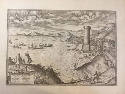
Sold2021Early Hand-Colored Map of VeniceItaly, ca. 16th-17th century. Fine hand-colored engraved map of "Venetia" with boats in harbor and compass rose. Handsomely framed. MEASUREMENTS Sight wide: 5 7/8 / 15 cm. Sight height: 4 1/2 / 11.5 cSee Sold Price
Sold2020Hand Colored Map Of ItalyHand colored map of Italy, Robert circa 1770, 13" x 14" unframed, 20" x 21" framed. Provenance: John's Island, Vero Beach, Florida.See Sold Price
Sold20231742 antique MAP of ITALY ITALIA IN FUOS STATUS 18th CENTURYITALIA IN FUOS STATUS Status divisa et ex prototypo del Isliano by Homann, Johann Baptist, 1663-1724 Nuremberg, 1742 size 20.5 by 25" Good condition, some wear, trimmed lower margin Reserve: $140.00 SSee Sold Price
Sold2019Map of Italy With the Ancient and Modern Names;Reserve Reduced! Title: Map of Italy With the Ancient and Modern Names; Publication Date: 1839 Cartographer: Pierre Tardieu Publisher: A. & W. Galignani & Co. Size (inches): 20.25Height - 16Width compSee Sold Price
Sold2020Rollin, Charles 1780 Map of Italy"Expedition of Hannibal wherein his Passage into Italy" Copper Engraved Map Published 1780, London for "The Ancient History..." by Charles Rollin. Folds as issued. Paper Size: 20 x 12 inch (50 x 30cm)See Sold Price
Sold20161812 Pinkerton Map of Southern ItalyCirca 1812 map. Frame: 33.75" x 26" image sight: 28.5" x 20.75"See Sold Price
Sold2017Braun & Hogenberg: Antique Map of Naples Italy, 1572Map: Naples Italy Date Printed: 1572-1618 Cartographer: Braun & Hogenberg / Mostly edited by Braun a clericmostly engraved by Hogenberg Material/Medium: Paper Size: 20 1/2" x 16" Civilates Orbis TerraSee Sold Price
Sold2024VIENNA & ROME. City plans. Wien. Roma. Austria. Italy. JOHNSTON 1900 old mapTITLE/CONTENT OF MAP: 'Vienna (Wien) and its environs; Rome and environs' DATE PRINTED: 1900 IMAGE SIZE: Approx 26.5 x 20.0cm, 10.25 x 7.75 inches (Medium) TYPE: Antique colour map CONDITION: Good; suSee Sold Price
Sold2017Mattheus Seutter, Antique Map of Firenza, c.1730Antique map of Firenza / Florence, Italy by Mattheus Seutter, Augsburg c.1730. Copperplate engraving, the image measures 18-7/8" x 22". Sheet measurement 20-3/8" x 25". Elaborate cartouche of the citySee Sold Price
Sold20171572 Ortelius Map of Tuscany and Siena1572 Ortelius Map of Tuscany and Siena - Senensis Ditionis, Accurata Descrip A. Ortelius 1572 Antwerp 13 x 9.5 in., 20 x 16 in. matted A lovely map of a portion of Tuscany in Italy featuring Siena neaSee Sold Price
Sold2021Venice, Italy Panorama ViewVenetia. Bird's-eye panorama harbor map view. F.B. Werner. Vintage color print. 18 3/4" x 39 1/2".See Sold Price
Sold2017Stackhouse: Antique Map of Ancient Northern Italy, 1783Title/Content of Map: Ancient Northern Italy Date Printed: 1783 Cartographer: Thomas Stackhouse Material/Medium: Paper Size: 16" x 20" Original hand color. Copperplate engraved. Published in 'An UniveSee Sold Price
Sold2017Stackhouse: Antique Map of Ancient Southern Italy, 1783Title/Content of Map: Ancient Central and Southern Italy Date Printed: 1783 Cartographer: Thomas Stackhouse Material/Medium: Paper Size: 16" x 20" Original hand color. Copperplate engraved. PublishedSee Sold Price
Sold2018Gulf of Gaeta (One of the oldest towns in Italy).Title/Content of Map: Gulf of Gaeta (One of the oldest towns in Italy). Date: 1572-1617 Size: 20 1/2 x16” from civitates Orbis Terrarum by Braun & Hogenberg , Cologne. Please note that this lot hasSee Sold Price
Sold2017Cabiahi: Antique Map of Ancient East Mediterranean 1845Map: Siria Cipro, Creta Egitto Cirenaica Marmarica ed Arabia Carta di Geografica Antica Cartographer: G. Cabiahi Place & Date: Italy / 1845 Size: 20" 1/2 x 14 1/8" Condition: outline color; overall agSee Sold Price
Sold2018ANTIQUE ITALIAN MILITARY MAP HANDKERCHIEF C 1884An antique Italian handkerchief printed with Military Circumscriptions of Italy, dated 1884. Color border. Visible part of handkerchief measures 20.25" tall x 23" wide. Frame measures 24.25" tall x 27See Sold Price
Sold2020Johnson's Roman Empire. Imperium Romanorum LatissimeTitle/Content of Map: Johnson's Roman Empire. Imperium Romanorum Latissime Patens Cartographer: JOHNSON, ALVIN JEWETT Date: 1864 Publisher: JOHNSON AND WARD Size: 13Height - 20.75Width Insets of ItalySee Sold Price
1 day LeftJasper521799 Cary Map of Northwest Italy -- A New Map of Piedmont, the Duchies of Savoy and Milan; and the$70
1 day LeftJasper521799 Cary Map of Northeast Italy, Including Venice -- A New Map of the County of Tyrol, and the$50
1 day LeftJasper521863 Johnson Map of the Roman Empire -- Johnson's Roman Empire, Imperium Romanorum Latissime Patens$45
BonhamsIRELAND (SAMUEL) Picturesque Views on the Upper, or Warwickshire Avon... to Its Junction with th...£300(1 bid)
Jun 25Freeman's | Hindman[Maps & Atlases] Seutter, Matth(ias).: Novus Orbis sive America...$300(1 bid)
Jun 25Freeman's | Hindman[Maps & Atlases] A New Map of North America, with the West India Islands...$300
BonhamsLEWIS (WYNDHAM, EDITOR) Blast. Review of the Great English Vortex, No. 1 (of 2), John Lane, 20 J...£220(9 bids)
Featured1 day LeftJasper521799 Cary Map of Hungary -- A New Map of Hungary, with Its Divisions into Gespanchafts or Counties;$70
BonhamsTHEATRE SCENERY - ITALY STUCCHI (STANISLAO, publisher) Raccolta di varie scene eseguite dai pi&#...£260(4 bids)
3 days LeftSwann Auction GalleriesCARL ROSE (1903-1971) Greenwich Village Street Maps and Landmarks.$600


![[Italy, Venetia & Friuli, Maps] 20 maps First Image](https://p1.liveauctioneers.com/2198/81135/42158521_1_x.jpg?height=300&quality=1&version=1447166404&width=300)
![[Italy, Venetia & Friuli, Maps] 20 maps First Image](https://p1.liveauctioneers.com/2198/81135/42158521_1_x.jpg?height=300&quality=95&version=1447166404&width=300)


![[Maps & Atlases] Seutter, Matth(ias).: Novus Orbis sive America... (1 of 2)](https://p1.liveauctioneers.com/65/332523/179335174_1_x.jpg?height=282&quality=70&version=1717709447)
![[Maps & Atlases] A New Map of North America, with the West India Islands... (1 of 2)](https://p1.liveauctioneers.com/65/332523/179335173_1_x.jpg?height=282&quality=70&version=1717709447)


