Sold2016Unknown - Japanese Map Of The World; People Of ManyUnknown - Japanese Map Of The World; People Of Many NationsSee Sold Price
Sold20211890 Map of JapanAuthor: Watson Title: 1890 Map of Japan Medium: Ink on Paper Dimensions: 11.5"X14.5" Map of Japan dated 1890. Printed by Watson for People's Publishing Co. Part of his World Atlas. Published in ChicagSee Sold Price
Sold20201913 World People Migration MapAuthor: Perthes Title: 1913 World People Migration Map Medium: Ink on Paper Dimensions: 14"X12" Double folio map dated 1913 engraved by Justus Perthes. Published by Sydow Wagners in Berlin and then LeSee Sold Price
Sold2020Lot of 4 Table Lighters Lighter/Case Combo & Kent FrameLot of 4 Table Lighters (Crystal w/ Chip shown, Brown & Bigalow Statesman Rememberance World Map, M.T.C. Japan & Elite) Lighter/Case Combo (Evans) & a Kent Cigarettes Advertising picture Frame - see pSee Sold Price
Sold2021WWII UNITED PRESS WAR MAP w 7 INDIVIDUAL MAPS JAPANTitle: WWII UNITED PRESS WAR MAP w 7 INDIVIDUAL MAPS JAPAN HAWAII WORLD PACIFIC THEATER Additional Information: WWII UNITED PRESS WAR MAP w 7 INDIVIDUAL MAPS JAPAN HAWAII WORLD PACIFIC THEATER WWII UNSee Sold Price
Sold2018Rand, McNally & Co.'S Indexed Atlas of the World Map ofReserve Reduced! Title/Content of Map: Rand, McNally & Co.'S Indexed Atlas of the World Map of Japan.Date: 1892 Cartographer: RAND, MCNALLY & CO. Material/Medium: RAND, MCNALLY & CO. Size: 19 x 25.8 iSee Sold Price
Sold2019Delamarche, Felix 1829 Map Dispersion of People, World"Carte de la Dispersion des Peuples apres le Deluge" Copper Engraved Map Published 1829, Paris for "Atlas de La Geographie..." by Felix Delamarche. Contemporary outline hand colour. Centre fold as pubSee Sold Price
Sold20231902 1ed JAPAN & Her People Tokyo Kyoto Buddhist Temple COLOR Illustrated MAP1902 1ed JAPAN & Her People Tokyo Kyoto Buddhist Temple COLOR Illustrated MAP Japan and Her People is an account of Japan at the turn of the century with additional photogravure illustrations. The twoSee Sold Price
Sold20211902 1ed Japan & Her People Tokyo Kyoto Buddhist Temple1902 1ed Japan & Her People Tokyo Kyoto Buddhist Temple COLOR Illustrated MAP ‘Japan and Her People’ is an account of Japan at the turn of the century with additional photogravure illustrations. TSee Sold Price
Sold20241902 JAPAN 1ed Her People Tokyo Kyoto Buddhist Temple COLOR Illustrated MAP1902 JAPAN 1ed Her People Tokyo Kyoto Buddhist Temple COLOR Illustrated MAP Japan and Her People is an account of Japan at the turn of the century with additional photogravure illustrations. The two vSee Sold Price
Sold2022[WORLD WAR II]. Collection of photographs, Japanese maps, and a diary collected by USN Lt. Cmdr. J.[WORLD WAR II]. Collection of photographs, Japanese maps, and a diary collected by USN Lt. Cmdr. J. John Fox while stationed in the Pacific, including: 53 reconnaissance photos from the Battle of OkinSee Sold Price
Sold20211st ed. Colton map of Japan – 1855From the first edition of Colton’s Atlas of the World comes this highly detailed map of Japan. Shown in a pleasing composition with a post-card size inset of Yesso and the Japanese Kuriles in the upSee Sold Price
Sold2020New Hampshire 1886Title/Content of Map: New Hampshire 1886 Date Printed: 1886 Material/Medium: paper Size: 13.5x21 inches Additional Info: he People's Unrivaled Family Atlas of the World. People's Publishing Co, ChicagSee Sold Price
Sold2020California 1886Title/Content of Map: California 1886 Date Printed: 1896 Material/Medium: paper Size: approx. 21.5x13.5 inches Additional Info: The People's Unrivaled Family Atlas of the World. People's Publishing CoSee Sold Price
Sold2020Spain & Portugal 1886Title/Content of Map: Spain & Portugal 1886 Date Printed: 1886 Material/Medium: paper Size: approx. 19x13 inches Additional Info: The People's Unrivaled Family Atlas of the World. People's PublishingSee Sold Price
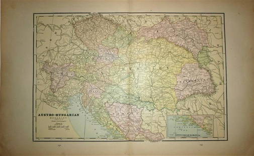
Sold2020Austro -Hungarian Monarchy 1886Title/Content of Map: Austro -Hungarian Monarchy 1886 Date Printed: 1886 Material/Medium: paper Size: Approx. 13.5x21 inches The People's Unrivaled Family Atlas of the World. People's Publishing Co, CSee Sold Price
Sold2020Michigan, Wisconsin 1886Title/Content of Map: Michigan, Wisconsin 1886 Date Printed: 1886 Material/Medium: paper Size: approx 13.5x21 inches Additional Info: The People's Unrivaled Family Atlas of the World. People's PublishSee Sold Price
Sold2020Ontario 1886Title/Content of Map: Ontario Date Printed: 1886 Material/Medium: paper Size: approx 13.5x11 inches Additional Info: The People's Unrivaled Family Atlas of the World. People's Publishing Co, Chicago.See Sold Price
Sold2022MAP, Japan & Korea, MercatorHondius' Richly Ornamented Map of Japan. Japan & Korea. Mercator/Hondius, Iaponia, from Gerardi Mercatoris - Atlas sive Cosmographicae, 1634 (published). Hand Color. Superb map of Japan based on the OSee Sold Price
Sold2022MAP, Japan & Korea, JanssonJapan & Korea. Jan Jansson, Nova et Accurata Iaponiae, Terrae Esonis, ac Insularum Adjacentium. Ex Novissima Detectione Descriptio, from Atlas Contractus, 1666 (circa). Hand Color. This superb folio mSee Sold Price
Sold2023MAP, Japan, YamashitaOmi Province, Japan. Shigemasa Yamashita, [Omi Province] ?mi no Kuni saikenzu, 1824 (circa). Black & White. This wall-sized woodblock map of the Omi Province was created by Shigemasa Yamashita. This hSee Sold Price
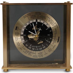
Sold2020Seiko World Desk ClockDESCRIPTION: A Seiko desk clock. Features a world map dial with white colored hands and airplane motif seconds hand. Marked "Seiko, Quartz Japan" Finished with time zone markers and a gilt brass case.See Sold Price
Sold2019Bartholomew, John 1922 Pair of Large Maps of JapanLarge Lithograph Map Published 1922 by The Times, London for "The Times Survey Atlas of the World" Maps by John George Bartholomew of the Edinburgh Geographical Institute. Centre fold as issued. PaperSee Sold Price
Sold2021Lot of Japanese Books and Maps, Edo-early Meiji periodLot of Japanese woodblock printed books and maps, Edo-early Meiji period, mostly on travel and geography. Comprising of:1. Bankoku orai (Views of the World 万国往来), by Yomo SSee Sold Price
13 hrs LeftTrillium Antique Prints & Rare BooksSanson - Map of the Philippines and Ladrones Islands$75
13 hrs LeftTrillium Antique Prints & Rare BooksSanson - Map of the Sunda Islands, Sumatra, Java, & Borneo$75
Jun 01Trillium Antique Prints & Rare BooksSanson - Map of Florida (encompassing most of Southeast North America)$75
Jun 01Trillium Antique Prints & Rare BooksSanson - Map of Canada or New France with the Great Lakes$75
Jun 01Trillium Antique Prints & Rare BooksSanson - Map of the British Isles (Ireland, Scotland, England)$75
Jun 20The Ross Art GroupOriginal Vintage Chocolat Menier Le Tour de Monde Poster by Jannot 1956 Chocolate Map$500
7 days LeftFreeman's | Hindman[WORLD WAR II] -- JAPANESE INTERNMENT]. Instructions to All Persons of Japanese Ancestry... [Western$250
6 days LeftThe Rug LifeTHE SECOND WORLD WAR AND HISTORY OF ENGLISH-SPEAKING PEOPLE, BOTH BY SIR WINSTON CHURCHILL. 9$300(1 bid)
Jun 23Schilb Antiquarian Rare Books1977 JRR Tolkien 1st ed Silmarillion Lord of the Rings Middle Earth + MAP$8(3 bids)
5 days LeftJasper52Antique engraving. Second Floor of Noah's Ark or Middle Floor of the Arke. Joodse Oudheden from$500


![[WORLD WAR II]. Collection of photographs, Japanese maps, and a diary collected by USN Lt. Cmdr. J.: [WORLD WAR II]. Collection of photographs, Japanese maps, and a diary collected by USN Lt. Cmdr. J. John Fox while stationed in the Pacific, including: 53 reconnaissance photos from the Battle of Okin](https://p1.liveauctioneers.com/197/250551/130130063_1_x.jpg?height=310&quality=70&version=1654185975)


![MAP, Japan, Yamashita: Omi Province, Japan. Shigemasa Yamashita, [Omi Province] ?mi no Kuni saikenzu, 1824 (circa). Black & White. This wall-sized woodblock map of the Omi Province was created by Shigemasa Yamashita. This h](https://p1.liveauctioneers.com/6576/279721/147265524_1_x.jpg?height=310&quality=70&version=1677104593)


![[WORLD WAR II] -- JAPANESE INTERNMENT]. Instructions to All Persons of Japanese Ancestry... [Western (1 of 1)](https://p1.liveauctioneers.com/197/329785/177758389_1_x.jpg?height=282&quality=70&version=1715625218)


