Sold2016Large Framed World Map w/ Latin InscriptionsLarge Framed World Map w/ Latin Inscriptions. Hand colored. Professionally framed and matted. Titled Mappe Monde. Measures 28 by 33 inches.See Sold Price
Sold2024Nova Totius Full Color Geographical World MapVintage full color world map in Latin, reading Nova Totius Terrarum Orbis Geographica Ac Hy Drographica Tabula. Depicts the world map with Latin sections and margins are filled with Greco Roman figureSee Sold Price
Sold2022Pair of Spinning Latin Old World Globe BookendsSpinning globe bookends with old world maps and Latin labels.See Sold Price
Sold2016[Latin Literature] Macrobius, In somnium Scipionis 1542A CLASSIC WORK OF LATIN LITERATURE, WITH THE FAMOUS MACROBIUS WOODCUT WORLD-MAP, AND OTHER 7 WOODCUT DIAGRAMSAPPARENTLY NO COPY IN USA Macrobius, Ambrosius Aurelius Theodosius. Macrobii Ambrosii AureSee Sold Price
Sold2024Vintage Full Color World Map LithographVintage full colored world map, reading Typvs Orbis Terrarvm with blue and red colors and scrolled motifs with Greco Roman lion and Figural heads and sections in Latin Frame in a tan toned wooden framSee Sold Price
Sold2024Abraham Ortelius map of Bitiurigum from Theatrum Orbis TerrarumTheatrum Orbis Terrarum, meaning "Theatre of the World" in Latin, is a landmark atlas published in 1570 by Abraham Ortelius, Theatrum Orbis Terrarum wasn't just a collection of maps; it was a significSee Sold Price
Sold2023World: Ptolemy, pub. 1562 - Map of the Ancient WorldThis early map engraving is Joseph Moleti (Giseppi Moleti [Moletius])'s edition of Claudius Ptolemaeus (Ptolemy)'s Geographia. This is the first Moleti Latin edition of the work and was published by VSee Sold Price
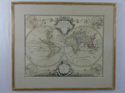
Sold2020Latin Double Hemisphere Map in Bronze FrameDouble hemisphere map of the world by Henricus Hondius II (Dutch, 1597-1651), offset print, in a bronze frame. [Sight: 20 1/2 x 29 1/2 inches; Frame: 22 x 31 inches]. In good condition.See Sold Price
Sold2022ORTELIUS, ABRAHAM; and PHILILLPE GALLE. Set of 5 miniature maps of the world and continents.ORTELIUS, ABRAHAM; and PHILILLPE GALLE. Set of 5 miniature maps of the world and continents. Engravings with original hand-color. 4x5½ inches each sheet size, Latin text on verso; light finger soSee Sold Price
Sold2023OVERSIZED REPRODUCTION OF A 16TH C. MAPMonumental and highly decorative offset lithograph reproduction map of the world by Giovanni Marfei after Abraham Ortelius, originally published c. 1589 or 1593. Dimensions: (Frame) H 45" x W 84" CondSee Sold Price
Sold201511 maps from: Anson, A Voyage Round the World.[Pacific/Travel/Latin America] 11 folding maps from a 4to edition of George Anson, “A Voyage Round the World in the Years MDCCXL, I, II, III, and IV…,” [1748 or later]. Many have “R. W. SealeSee Sold Price
Sold2016T-O World Map.- Lucanus (Marcus Annaeus) Pharsalia,Lucanus (Marcus Annaeus) Pharsalia, manuscript on paper, [Northern Italy (possibly Padua), first half of the fifteenth century]. 294 x 217mm., I + 149 + I leaves (including defective leaves and 3 blanSee Sold Price
Sold2024Petrus Plancius, Engraved World MapOrbis Terrarum Typus de Integro Multis in Locis Emendatus. Petrus Plancius (1552-1622). Copper-plate engraving with original hand color in full. Amsterdam, 1594. Some stains, creases, folds. Sight sizSee Sold Price
2022Blaeu, Johannes (Netherlands, 1596-1673) "The New World Map" Double Hemisphere World Map C. 1664Nova et Accuratissima Totius Terrarum Orbis Tabula Translated "The New World Map", Hand Colored w/ Elaborately Decorated Spandrels.   Sight View 16" x 21-1/2", Overall View 21" x 25-1/2"See Sold Price
Sold2018Ortelius' 1570 world mapHeading: Author: Ortelius, Abraham Title: Typus Orbis Terrarum Place Published: Antwerp Publisher: Date Published: 1570-[1584?] Description: Copper-engraved map, hand-colorSee Sold Price
2018Important World Map from the Nuremberg Chronicle, 1493Title/Content of Map: World Map from the Nuremberg Chronicle. One of the most important world Maps ever produced Date Printed: 1493 Cartographer: Hartmann Schedel Material/Medium: Paper Size: 18" x 25See Sold Price
Sold2023A Witco Tiki Art World MapWorld Map mixed media sculpture mid century modern Witco 37.25 x 62.25 inches Overall very good condition.See Sold Price
Sold2017World mapWorld map 'Nova Totius Terraum Orbis Geographica Ac Hydrographica Tabula', copper engraving map of Heinrich Hondius, dated 1630,two hemispheres the world map, surrounded by rich allegorical representaSee Sold Price
Sold2020Mercator World Map*** START PRICE IS THE RESERVE *** [World] MERCATOR, Rumold (1545-1599). Orbis Terrae Compendiosa Descriptio Quam ex Magna Universali Mercatoris... Engraved Map with original hand color. Geneva, 1587.See Sold Price
Sold2022Massive World Map Custom-Made Coffee Table 1995One of a kind, all iron and custom glass work, signed in 1995. Aprox. Weight: 200 lbs -Measurements: 65 in L x 40 in x 23 in HSee Sold Price
Sold2016Beautifully Colored Jan Van Loon World MapOrbis Terrarum Nova... Jan Van Loon (c. 1611-1686). Engraved map with original hand color in full. London: Moses Pitt, 1680. 17 3/4 x 21 inches visible, 28 1/4 x 31 3/4 inches framed. A fine example oSee Sold Price
Sold2016Celebrated 16th Century World Map by Abraham OrteliusTypvs Orbis Terrarvum, Antwerp, dated 1587, with hand-coloring; Spanish text on the back credits the cartographer's sources in this updated edition showing the Solomon Islands and a corrected South AmSee Sold Price
Sold2017FRAMED WORLD MAP BY HERMAN MOLL, 1719'A New & Correct Map of the Whole World, by Herman Moll, Geographer, 1719.' Hand tinted and framed. Frame size: 73 x 124 cm (28 3/4 x 48 3/4 in.)See Sold Price
7 days LeftFreeman's | Hindman[MAP]. ORTELIUS, Abraham. Americae Sive Novi Orbis, Nova Descriptio. 1573.$1,000(1 bid)
20 hrs LeftTrillium Antique Prints & Rare BooksBraun & Hogenberg, pub. 1575 - View of Ostia, Italy$140(2 bids)
20 hrs LeftTrillium Antique Prints & Rare BooksBraun & Hogenberg, pub. 1575 - Views in the Middle East: Aden, Mombasa, Kilwa, & Sofala$100(1 bid)
20 hrs LeftTrillium Antique Prints & Rare BooksBraun & Hogenberg, pub. 1575 - View of Delft, Netherlands$100
20 hrs LeftTrillium Antique Prints & Rare BooksBraun & Hogenberg, pub. 1575 - View of Alexandria, Egypt$100(1 bid)
20 hrs LeftTrillium Antique Prints & Rare BooksBraun & Hogenberg, pub. 1575 - View of Chester, England$100
20 hrs LeftTrillium Antique Prints & Rare BooksBraun & Hogenberg, pub. 1575 - View of Lyon, France$100
Jun 08Trillium Antique Prints & Rare BooksBraun & Hogenberg, pub. 1575 - View of Wroclaw (Breslau), Poland$100
Jun 08Trillium Antique Prints & Rare BooksBraun & Hogenberg, pub. 1575 - View of Bristol, England$100
Jun 08Trillium Antique Prints & Rare BooksBraun & Hogenberg, pub. 1575 - Views of Italy: Urbino and Sulmona$100
Jun 08Trillium Antique Prints & Rare BooksBraun & Hogenberg, pub. 1575 - View of Castle of Segeberg (Burg Segeberg) in Holstein, Germany$100
4 days LeftJasper521833 Woodbridge World Map -- Map of the World Adapted to Woodbridge's Geography$40
Jun 09Worthington Galleries19th c. Hemisphere World Map, Hohen und Tiefen der Erde in Lambert’s Zenithal-Projection von$10
4 days LeftJasper521881 Vuillemin World Map with French Colonies Shown -- Planisphere: Indiquant les Colonies Francises$30
22 hrs LeftRapid Estate Liquidators and Auction GalleryVintage Cricket Gillette World Map Lighter Holder$10


![[Latin Literature] Macrobius, In somnium Scipionis 1542: A CLASSIC WORK OF LATIN LITERATURE, WITH THE FAMOUS MACROBIUS WOODCUT WORLD-MAP, AND OTHER 7 WOODCUT DIAGRAMSAPPARENTLY NO COPY IN USA Macrobius, Ambrosius Aurelius Theodosius. Macrobii Ambrosii Aure](https://p1.liveauctioneers.com/2198/96026/49166112_1_x.jpg?height=310&quality=70&version=1480075738)


![World: Ptolemy, pub. 1562 - Map of the Ancient World: This early map engraving is Joseph Moleti (Giseppi Moleti [Moletius])'s edition of Claudius Ptolemaeus (Ptolemy)'s Geographia. This is the first Moleti Latin edition of the work and was published by V](https://p1.liveauctioneers.com/6581/307341/164260812_1_x.jpg?height=310&quality=70&version=1698409008)
![Latin Double Hemisphere Map in Bronze Frame: Double hemisphere map of the world by Henricus Hondius II (Dutch, 1597-1651), offset print, in a bronze frame. [Sight: 20 1/2 x 29 1/2 inches; Frame: 22 x 31 inches]. In good condition.](https://p1.liveauctioneers.com/1221/177486/89638020_1_x.jpg?height=310&quality=70&version=1599275200)


![11 maps from: Anson, A Voyage Round the World.: [Pacific/Travel/Latin America] 11 folding maps from a 4to edition of George Anson, “A Voyage Round the World in the Years MDCCXL, I, II, III, and IV…,” [1748 or later]. Many have “R. W. Seale](https://p1.liveauctioneers.com/179/82189/42599766_1_x.jpg?height=310&quality=70&version=1447864785)
![T-O World Map.- Lucanus (Marcus Annaeus) Pharsalia,: Lucanus (Marcus Annaeus) Pharsalia, manuscript on paper, [Northern Italy (possibly Padua), first half of the fifteenth century]. 294 x 217mm., I + 149 + I leaves (including defective leaves and 3 blan](https://p1.liveauctioneers.com/5458/94966/48431616_1_x.jpg?height=310&quality=70&version=1476369049)


![Ortelius' 1570 world map: Heading: Author: Ortelius, Abraham Title: Typus Orbis Terrarum Place Published: Antwerp Publisher: Date Published: 1570-[1584?] Description: Copper-engraved map, hand-color](https://p1.liveauctioneers.com/642/127929/65081054_1_x.jpg?height=310&quality=70&version=1537227236)


![Mercator World Map: *** START PRICE IS THE RESERVE *** [World] MERCATOR, Rumold (1545-1599). Orbis Terrae Compendiosa Descriptio Quam ex Magna Universali Mercatoris... Engraved Map with original hand color. Geneva, 1587.](https://p1.liveauctioneers.com/1968/163248/82424686_1_x.jpg?height=310&quality=70&version=1583340284)


![[MAP]. ORTELIUS, Abraham. Americae Sive Novi Orbis, Nova Descriptio. 1573. (1 of 2)](https://p1.liveauctioneers.com/197/329395/177650534_1_x.jpg?height=282&quality=70&version=1715364962)
![[MAP]. ORTELIUS, Abraham. Aevi Veteris, Typus Geographicus. 1601. (1 of 3)](https://p1.liveauctioneers.com/197/329395/177650532_1_x.jpg?height=282&quality=70&version=1715364962)


