Sold2024De Jode, pub. 1593 - Map of Gelderland, Netherlands, Dutch Province (Geldria?)This truly significant map is from one of the rarest atlases ever published, Gerard and Cornelis de Jode's Speculum orbis Terrae. The work was published in Antwerp in 1593 by Arnold Coninx for the widSee Sold Price
Sold2022Netherlands region of Gelderland. 1730, By J. OttensTitle: Netherlands region of Gelderland. 1730, By J. Ottens Date/Period: 1730 Materials: Hand colored copper plate engraved Size: 24 x 19 1/2 inches Additional Information: Netherlands area of GelderlSee Sold Price
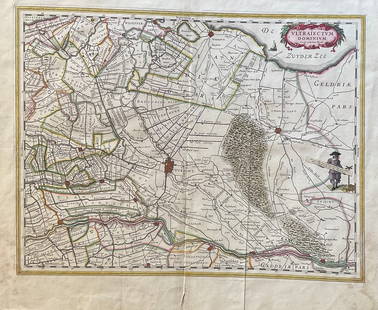
Sold2023The Netherlands Map. The region Around the city of Utrecht. 1660?s by W. BlaeuTitle: The Netherlands Map. The region Around the city of Utrecht. 1660?s by W. Blaeu Date/Period: 1660?s Materials: Hand colored copper plate engraved Size: 22 x 19 1/2'' Netherlands regional map cenSee Sold Price
Sold2020RARE map of Friesland in the NetherlandsTitle: RARE map of Friesland in the Netherlands Date/Period: 1596 Materials: Copperplate engraved Size: 14" x 10 1/4" Description: One of the new detailed map of the region not made in the Low CountriSee Sold Price
Sold2020Netherlands 1747 Map of Holland, Utrecht"A New & Exact Map of the Provinces of Holland, Utrecht, Gelderland, Zeeland, Dutch Flanders and Dutch Brabant" Copper Engraved Map Published 1732-85, London for "The London Magazine" Folds as issued.See Sold Price
Sold2022The Netherlands. 1st French Empire Belgium w/ 13 Départements. THOMSON 1830 mapTITLE/CONTENT OF MAP: 'Belgium or the Netherlands' Belgium shown under the First French Empire, with 13 Départements; although Napoleon's rule over the region had ended with his defeat at WaterloSee Sold Price
Sold2024SOUTH-WEST PACIFIC. Melanesia Micronesia Indonesia Philippines 1952 old mapTITLE/CONTENT OF MAP: 'South-West Pacific' Netherlands New Guinea (Dutch: Nederlands-Nieuw-Guinea), the West Papua region is shown as Dutch: it was an overseas territory of the Kingdom of the NetherlaSee Sold Price
Sold2024Jan Van Ravesteyn Dutch Old Master Portrait Gentleman & DogTITLE:Jan Van Ravesteyn Ducth Old Master Portrait Gentleman & Dog TYPE:Art SUB TYPE:Painting REGION:Europe SUB REGION:Netherlands MEDIUM:Oil SGD/UNS:Signed DATE OF WORK:C 1640s CATALOG NOTES:An excellSee Sold Price
Sold2018Old Master Portrait Man W/ Beard Lievens ?TYPE:Art SUB TYPE:Painting REGION:Europe SUB REGION:Netherlands MEDIUM:Oil SGD/UNS: TITLE:Old Master Portrait Man W/ Beard Lievens ? CATALOG NOTES:A fine large original oil portrait featuring a gentleSee Sold Price
Sold2024Old Master Italian Flemish 16th C Panel Portrait Woman In LandscapeTITLE:Old Master Italian Flemish 16th C Panel Portrait Woman In Landscape TYPE:Art SUB TYPE:Painting REGION:Europe SUB REGION:Netherlands MEDIUM:Oil SGD/UNS:Unsigned DATE OF WORK:16th C CATALOG NOTES:See Sold Price
2024Andreas Schelfhout Netherlands Dutch Luminist Beach Scene Sun Ships CliffsTITLE:Andreas Schelfhout Netherlands Dutch Luminist Beach Scene Sun Ships Cliffs TYPE:Art SUB TYPE:Painting REGION:Europe SUB REGION:Netherlands MEDIUM:Oil SGD/UNS:Unsigned DATE OF WORK:C 1840s-50s CASee Sold Price
Sold2023JANSSONIUS JOANNES MAP/ NOVA BELGICA & ANGLIA NOVAIdentified in pencil "Jansson 1650" on both sides. Double-page engraved map with Latin text verso; hand-colored in outline. printed on laid paper 19 3/4 x 23 inches (sheet) 23 x 27 inches (overall). PSee Sold Price
Sold2018Antique John Smith Atlantic Region Map Virginia OrigState 10: Page 41, numbers changed to 1690 and 1691. A true piece of American history, not a reproduction!Fine example of John Smith's map of the newly formed Virginia colony, one of the true milestonSee Sold Price
Sold2021Rob Parry, 'Lotus' Lounge Chairs (2)Rob Parry Pair of 'Lotus' lounge chairs, 1950s Walnut, leather, metal, brass. Manufactured by Gelderland, The Netherlands. Dimensions: 32.25" H 25" W 31" D.See Sold Price
Sold2022Rob ParryRob Parry (1925-)Teak sofa bed with sand-coloured upholstery, design Rob Parry for Gelderland, the Netherlands, design year ca. 1960, 210 cm wideSee Sold Price
Sold2024ROB PARRY FOR GELDERLAND SOFA-DAYBED, C. 1960'SBlack steel frame with teak arms and red woven fabric. Designed by Rob Parry for Gelderland, the Netherlands, c. 1960's. Dimensions: H 26" x W 82.5" x D 33" x SH 17.5" Condition: Presents very well ovSee Sold Price
Sold2024NICOLAES VISSCHER (NETHERLANDS, 1618-1709) MAP OF THE NEW WORLD"Novi Belgii Novaeque Angliae nec non Partis Virginie Tabula multis in locis emendata", 1656. Handcolored copperplate engraving on two joined sheets of wove paper as issued. Features cartouche panoramSee Sold Price
Sold2023 [MAPS - GREAT LAKES REGION]. VAUGONDY, Gilles Robert de (16...[MAPS - GREAT LAKES REGION]. VAUGONDY, Gilles Robert de (1688-1766). Les Lacs du Canada et Nouvelle Angleterre… Paris, 1749. Engraved map (229 x 318 mm) with hand-colored outlining, appearing toSee Sold Price
Sold2023Carel Allard, Map the Sevennes Region in South Central FranceCarel Allard, Map the Sevennes Region in South Central FranceAmsterdam, early 18th century, copperplate engraving with outline color; focusing of the Diocese of Monpellier; matted and framed under glaSee Sold Price
Sold2024Zatta map of Alaska region 1776Heading: Author: Zatta, Antonio Title: Nuove Scoperte de' Russi al Nord del Mare del Sud si nell' Asia, che nell' America Place Published: Venice Publisher: Date Published: 1776 DescriSee Sold Price
Sold2024Homann Map of New Spain 1720HOMANN, Johann Baptista (1664-1724). Regni Mexicani seu Novae Hispaniae. Engraved map. Nuremberg, 1720. 20" x 23 1/2" sheet. This superb map covers the region from the Great Lakes and Nova Scotia throSee Sold Price
Sold2024Exceptional 18th Century Map of The Carolinas, Maryland and VirginiaBy Johann Baptist Homann, Germany, late 17th/early 18th century. Hand colored map of the region which is excellent and quite rare. The map giving excellent details of the region and having exquisite eSee Sold Price
Sold2021Beautiful map of S.F. Bay Region 1873Heading: (California - San Francisco Bay Area) Author: California, State Geological Survey Title: Map of the Region Adjacent to the Bay of San Francisco... Place Published: [n.p.] Publisher: DateSee Sold Price
Sold2021Ukraine, one of the earliest detailed maps of theTitle: Ukraine, one of the earliest detailed maps of the country. 1762 by Homann Heirs Date/Period: 1762 Materials: Copperplate engraved Size: 24 x 20 1/2" The best detailed early map of the region. SSee Sold Price
4 days LeftJasper521792 Elwe Map of Southern Netherlands to Belgium to Northern France -- Carte Nouvelle des Pais Bas$80
7 days LeftRail & Road Auctions1934 Short Line Motor Coach Service Timetable and 1947 Michelin Map 6 of Netherlands$20
4 days LeftJasper521792 Elwe Map of the Netherlands and Belgium -- Les Dix-Sept Provinces des Pays-Bas$80
6 days LeftHunt and Peck Estate Services, Inc.Abraham Ortelius Map "Sabavdiae, et Bvrgvndiae Comitatus descriptio"$70
4 days LeftJasper521792 Elwe Map of Holland -- Carte Generale des Provinces Unies des Pais Bas et Terres Voisines?$80
4 days LeftJasper521680 Jansson/Duval Map of Middle East -- Tabula Itineris Decies Mille Graecorum sub Cyro Contra$140(1 bid)
4 days LeftJasper521579 Ortelius Map of Parts of Belgium and Holland -- Brabantiae, Germaniae Inferioris Nobilissimae$160
May 24Eldred'sWILLEM JOANNES SCHUTZ (The Netherlands, 1854-1933), Fishing boats and figures along the shoreline.,$100
4 days LeftJasper521764 Bowen Map of West India to Iran -- India As Described By All Authors Before The Fifth Century$80
6 days LeftHunt and Peck Estate Services, Inc.Jacques Nicolas Bellin Map Of Western Part Of New France Or Canada$200(1 bid)
6 days LeftHunt and Peck Estate Services, Inc.1713 Tho. Brodrick "A Compleat history of the late war in the netherlands$50
May 16Potter & Potter AuctionsGEESINK, Joop (1913 – 1984). Europa. 1957. Netherlands: KLM...$100
4 days LeftJasper521846 Quin Map of the Mediterranean and Persia During the Rule of Cyrus -- Fourth period : B.C. 529.$55


![[MAPS - GREAT LAKES REGION]. VAUGONDY, Gilles Robert de (16...: [MAPS - GREAT LAKES REGION]. VAUGONDY, Gilles Robert de (1688-1766). Les Lacs du Canada et Nouvelle Angleterre… Paris, 1749. Engraved map (229 x 318 mm) with hand-colored outlining, appearing to](https://p1.liveauctioneers.com/928/301544/160920958_1_x.jpg?height=310&quality=70&version=1694462960)


![Beautiful map of S.F. Bay Region 1873: Heading: (California - San Francisco Bay Area) Author: California, State Geological Survey Title: Map of the Region Adjacent to the Bay of San Francisco... Place Published: [n.p.] Publisher: Date](https://p1.liveauctioneers.com/642/204898/103986346_1_x.jpg?height=310&quality=70&version=1621652446)


![[COLOR PLATE BOOK]. MUDFORD, William (1782-1848). An Histor... (1 of 5)](https://p1.liveauctioneers.com/928/328184/176813588_1_x.jpg?height=282&quality=70&version=1714496988)