Sold2020MALAY ARCHIPELAGO Indonesia Malaysia PhilippinesTITLE/CONTENT OF MAP: 'EASTERN ISLANDS OR THE MALAY ARCHIPELAGO. Sumatra, Java, Borneo, etc' The top image on the right hand side shows the entire map. To view a close up of the map showing the levelSee Sold Price
Sold2020MALAY ARCHIPELAGO Indonesia Malaysia PhilippinesTITLE/CONTENT OF MAP: 'EASTERN ISLANDS OR THE MALAY ARCHIPELAGO. Sumatra, Java, Borneo, etc' The top image on the right hand side shows the entire map. To view a close up of the map showing the levelSee Sold Price
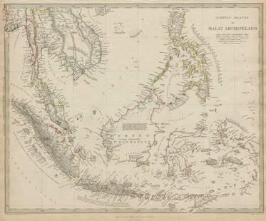
Sold2017Eastern Islands Or Malay Archipelago Map, 1836Eastern Islands Or Malay Archipelago. Baldwin & Cradock/S.D.U.K. 1836-12-01. Drawn from authorities Horsburgh, Raffles, Crawfurd, Duperray, Laplace &c. Printed by Russell, Penge. Please note that thisSee Sold Price
Sold2018Eastern Islands Or Malay ArchipelagoMap: Eastern Islands Or Malay Archipelago Date: 1852 Cartographer: WALKER, J. & C. Publisher: GEORGE COX/S.D.U.K. Size (inches): 12.5X16 Map showing southern Siam, Archipelago Filipino, Celebes, BorneSee Sold Price
Sold2022Earl, The Eastern Seas w/ four mapsHeading: Author: Earl, George Windsor Title: The Eastern Seas, or Voyages and Adventures in the Indian Archipelago in 1832-33-34, Comprising a Tour of the Island of Java- Visits to Borneo, the MalaySee Sold Price
Sold2021Tallis, John (Pub) 1852 Malay Archipelago. East IndiesSteel Engraved Map with Original Outline Hand Color Published 1852-56 by John Tallis, London for "The Universal Pronouncing Dictionary" by Thomas Wright. Drawn & Engraved by John Rapkin. Centre fold aSee Sold Price
Sold2021MALAY ARCHIPELAGO/EAST INDIA ISLANDS PhilippinesTITLE/CONTENT OF MAP: 'Malay Archipelago or East India Islands' Vignettes: Victoria Mount - New Guinea; Near Sarawak - Borneo; Natives of New Guinea; The Bee Bear. The map covers the area from Burma aSee Sold Price
Sold20241756 The Remote Chilean Juan Fernandez Archipelago, Eastern Robinson Crusoe Island, by G. AnsonTitle: 1756 The Remote Chilean Juan Fernandez Archipelago, Eastern Robinson Crusoe Island, by G. Anson Date/Period: 1756 Materials: Copper plate engraved Size: 17 1/2? x 20? This map depicts the remotSee Sold Price
Sold2021Tallis, John (Pub) 1852 Map. Eastern HemisphereSteel Engraved Map with Original Outline Hand Color Published 1852-56 by John Tallis, London for "The Universal Pronouncing Dictionary" by Thomas Wright. Drawn & Engraved by John Rapkin. Centre fold aSee Sold Price
Sold2021Tallis, John (Pub) 1852 Map Islands in the Indian OceanSteel Engraved Map with Original Outline Hand Color Published 1852-56 by John Tallis, London for "The Universal Pronouncing Dictionary" by Thomas Wright. Drawn & Engraved by John Rapkin. Centre fold aSee Sold Price
Sold2021Tallis, John (Pub) 1852 Map. Islands in the AtlanticShowing Canary Islands, Madeira and Bermuda. Steel Engraved Map with Original Outline Hand Color Published 1852-56 by John Tallis, London for "The Universal Pronouncing Dictionary" by Thomas Wright. DSee Sold Price
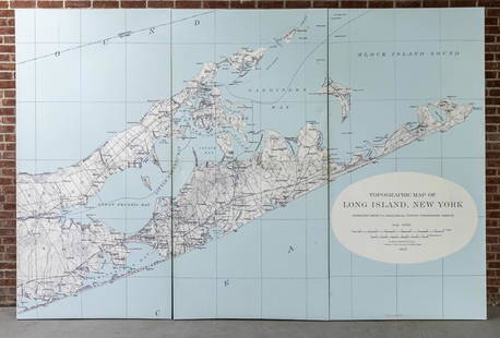
Sold2022Three Panel Water Current Map of Eastern Long Island on Canvas with FrameOver scaled Eastern Long Island water current map on three panel canvas, strengthened on frame. Please note of wear consistent with age. Each panel measures 48"W x 2"D x 96"H.See Sold Price
Sold2022Universal Atlas 1893 LG Map. Siam and the Malay ArchipelagoLithograph Map Published 1893 by Cassell & Co., London for "The Universal Atlas" Centre fold as issued. Paper Size: 16 x 10.5 inch (41 x 27cm) Good ConditionSee Sold Price
Sold2024Siam and the Malay Archipelago. Indonesia Indochina Philippines. TIMES 1895 mapTITLE/CONTENT OF MAP: 'Siam and the Malay Archipelago' DATE PRINTED: 1895 IMAGE SIZE: Approx 38.5 x 25.5cm, 15.25 x 10 inches (Large) TYPE: Antique colour atlas map CONDITION: Good; suitable for framiSee Sold Price
Sold2019Butler, George 1874 Pair of Maps. Asia & East Indies"Asia" and "The Malay Archipelago" Lithograph Maps Published 1874, London for "The Public School Atlas of Modern Geography" by Rev. George Butler. Paper Size: Up to 13.75 x 10.5 inch (35 x 27cm) GoodSee Sold Price
Sold2021Tallis, John (Pub) 1852 Map Falkland Islands, PatagoniaSteel Engraved Map with Original Outline Hand Color Published 1852-56 by John Tallis, London for "The Universal Pronouncing Dictionary" by Thomas Wright. Drawn & Engraved by John Rapkin. Centre fold aSee Sold Price
Sold2021Tallis, John (Pub) 1852 Map. Channel IslandsSteel Engraved Map with Original Outline Hand Color Published 1852-56 by John Tallis, London for "The Universal Pronouncing Dictionary" by Thomas Wright. Drawn & Engraved by John Rapkin. Centre fold aSee Sold Price
Sold2020Nautical Map / Sea Chart, #1212 Eastern Long IslandDescription: Nautical Map / Sea Chart, United States East Coast, Connecticut - New York, Long Island Sound, Eastern Part, 12th edition feb 10 / 69 ; all measurements are approximate; Folded; ShippingSee Sold Price
Sold2019Bartholomew, John 1922 Pair Large Maps of East Indies"Farther India" showing Siam, Indonesia, Singapore, Malaysia. Together with "Malay Archipelago" Large Lithograph Map Published 1922 by The Times, London for "The Times Survey Atlas of the World" MapsSee Sold Price
Sold2019Malaya 1911-1922 Pair of Maps of the East IndiesBoth titled "Malay Archipelago" Large Lithograph Maps Published 1922 by The Times, London for "The Times Survey Atlas of the World" Maps by John George Bartholomew of the Edinburgh Geographical InstitSee Sold Price
Sold2020Bartholomew, John 1922 Pair of Maps. East Indies"Farther India" and "Malay Archipelago" Large Lithograph Maps Published 1922 by The Times, London for "The Times Survey Atlas of the World" Maps by John George Bartholomew of the Edinburgh GeographicaSee Sold Price
Sold2018Bellin: Antique Map of Maluku Islands, 1740Title/Content of Map: Maluku Islands of Eastern Indonesia Date Printed: 1740-70's Cartographer: J.N. Bellin & J.F. La Harpe Material/Medium: Paper Size: 6" x 9 3/4" Copperplate engraved. Published inSee Sold Price
Sold2024New Zealand Sandwich Galapagos Islands. Papuan Archipelago. Melanesia 1860 mapCAPTION PRINTED BELOW PICTURE: 'New Zealand. // Sandwich Islands, or Hawaiian Group, // Galapagos Islands // Papuan Archipelago' The islands of New Zealand are named with their early colonial and MaorSee Sold Price
Sold2023New Zealand Sandwich Galapagos Islands. Papuan Archipelago. Melanesia 1859 mapNew Zealand. // Sandwich Islands, or Hawaiian Group, // Galapagos Islands // Papuan Archipelago' by John Bartholomew (1859). Antique engraved atlas map with original hand colour/color, 37.0 x 53.5cm,See Sold Price
5 days LeftJasper52MALAY ARCHIPELAGO/EAST INDIA ISLANDS. Philippines Indies. RAPKIN/TALLIS 1851 map$260
5 days LeftJasper52Arcipelago Mar Egeo. Aegean Cyclades Sporades Dodecanese ROSSI/CANTELLI 1685 map$280
5 days LeftSwann Auction Galleries(MISCELLANEOUS MAPS.) Group of 8 seventeenth-to-nineteenth-century engraved maps.$500
5 days LeftJasper52Chagos Islands Peros Banhos Egmont Salomon EAST INDIA CO. chart 1839 (1940) map$280
5 days LeftJasper52Océanique. Partie de l'ile de Java #27 Bali Lombok Sumbawa VANDERMAELEN 1827 map$260
3 days LeftJasper521869 MALAY ARCHIPELAGO by A.WALLACE antique illustrated w /MAPS 1st US EDITION$480
5 days LeftForum AuctionsChina.- Jansson (Jan) China Veteribus Sinarum Regio nunc Incolis Tame dicta, engraved map, [c. 1635]£200
4 hrs LeftTrillium Antique Prints & Rare BooksCatesby, Folio - Pair of Squirrel Engravings$200(1 bid)
3 days LeftJasper521896 STANFORD'S COMPEDIUM of GEOGRAPHY & TRAVEL ASIA 2 VOLS. antique ILLUSTRATED$220
5 days LeftSwann Auction Galleries(COLONIAL NEW YORK.) Major Samuel Holland. The Provinces of New York, and New Jersey; with part of$1,100


![China.- Jansson (Jan) China Veteribus Sinarum Regio nunc Incolis Tame dicta, engraved map, [c. 1635] (1 of 1)](https://p1.liveauctioneers.com/5458/332455/179303772_1_x.jpg?height=282&quality=70&version=1717586421)


