Sold2020AN ANTIQUE SURVEY MAP, "U.S. Coast Survey: PreliminaryAN ANTIQUE SURVEY MAP, "U.S. Coast Survey: Preliminary Sketch of Galveston Bay, Texas," SECOND EDITION, CIRCA 1852, lithograph on paper, map "I, No. 2," A.D. Bache, Superintendent, "Verified by I.I.See Sold Price
Sold2017Galveston Bay & Texas Land Company Certificate withGalveston Bay & Texas Land Company, Scrip No. 1070 for One Sitio, containing 4428 102/1000 English Acres. New York. October 16, 1830. 8 x 12.5 in. Featuring a map of the company's Texas land holdings,See Sold Price
Sold2017Mitchell: County Map of Texas, 1862County Map of Texas, S. Augustus Mitchell, 1862. 10.75 x 13.375 inches. Steel engraved map, with hand colored wash and outlines. Inset map of Galveston Bay, and Vicinity. Colored by county and territoSee Sold Price
Sold2023Flemming - Map of Texas with Inset of Galveston BayThis historic map of Texas is by Carl Flemming and titled "Texas." The map was published c1850 by the author. The map took inspiration from John Arrowsmith's Republic of Texas Map. There is an inset oSee Sold Price
Sold2018County Map of Texas.Title/Content of Map: County Map of Texas. Date Printed: 1870 Cartographer: MITCHELL, SAMUEL AUGUSTUS (JR.) Material/Medium: S. Augustus Mitchell, Jr. Size: 9.25X12 Inset of Galveston Bay and VicinitySee Sold Price
Sold2024Rare Galveston Bay & Texas Land Company Sitio ScripRare Galveston Bay & Texas Land Company Sitio Scrip An official document issued by the Galveston Bay & Texas Land Company, Scrip No. 802, issued in New York City on October 16, 1830, the day tSee Sold Price
Sold2022Galveston Bay & Texas Land Company Labor Scrip Made Out To Company President's SonGalveston Bay & Texas Land Company Labor Scrip Made Out To Company President's Son An official document issued by the Galveston Bay & Texas Land Company, Scrip No. 5999, issued in New York CitSee Sold Price
Sold2019Galveston Bay, Texas,Title: Galveston Bay, Texas, Publication Date: 10/1/1900 Cartographer: RICHE, CHARLES SWIFT (1865-1926) Publisher: GPO Size: 19.5Height - 24Width showing proposed improvement of Galveston Channel fromSee Sold Price
Sold2024Maria Cage Kimball (American/Galveston, Texas, 1844 - 1911)'Seagalls Over Rocks (Galveston Bay, Texas).' Pastel on paperboard. Signed bottom right. 6 x 10" ; 4 x 20" (overall).See Sold Price
Sold2022Galveston Bay and Texas Land Company Colonization Land Deed Nacogdoches 1830Described & Photographed By:Robin DBJQ 40224-L Title:Galveston Bay and Texas Land Company Colonization Land Deed Nacogdoches 1830 Description:Galveston Bay and Texas Land Company land deed for one lSee Sold Price
Sold2018U.S. Coast Survey 1853 Map of Galveston Entrace, Texas"(Sketch I No. 3) Galveston Entrance Texas" Electrotype Map Published 1843-65, Washington for "Report of the Superintendent of the U.S. Coast Survey..." Published under the supervision and direction oSee Sold Price
Sold2017Ramon Froman W/C "Galveston Bay"Ramon Mitchell Froman (Texas/New Mexico, 1908-1980) maritime watercolor on paper painting depicting a harbor with fishing boats titled "Galveston Bay". Signed, lower right. Titled with artist informatSee Sold Price
Sold2023Texas. 1861 by Johnson and BrowningTitle: Texas. 1861 by Johnson and Browning Date/Period: 1861 Materials: Steel engraved Size: 26 x 18” With inserts of the northern region, Galveston Bay, and a lake. 1861, by Johnson and BrowninSee Sold Price
Sold2024Excellent example 1852 Map of the State of TexasVery clean, comprehensive map of Texas, showing the new boundaries after the Compromise of 1850, with inset maps of the panhandle and Galveston. Locates Apaches in the western part of the state, ComanSee Sold Price
Sold2018Superb 1852 map of TexasReserve Reduced! Very clean, comprehensive map of Texas, showing the new boundaries after the Compromise of 1850, with inset maps of the panhandle and Galveston. Included are topographical details andSee Sold Price
Sold2023Rolla Sims Taylor (1872 - 1970) AMERICANRolla Sims Taylor Oil on Board, Signed, Measures (8 x 12 inches) w/frame ( 10.5 x 14.5) Rolla Sims Taylor, originally from Galveston, Texas, started painting at the age of 14. Before arriving in San ASee Sold Price
Sold2023Paul Richard Schumann (1876 - 1946) AmericanPaul Richard Schumann (1876 - 1946) Oil on Canvas on Board, Signed, Measures (16 x 20 inches) w/frame (20 x 24 inches) Born in Germany, Paul Richard Schumann moved to Galveston, Texas around 1882. HeSee Sold Price
Sold2023Rolla Sims Taylor (1872 - 1970) AmericanRolla Sims Taylor (1872 - 1970) Oil on board, Signed Lower Right, Measures (6 x 9 inches) w/frame (10 x 13 inches) Rolla Sims Taylor, originally from Galveston, Texas, started painting at the age of 1See Sold Price
Sold2023Rolla Sims Taylor (1872 - 1970) AmericanRolla Sims Taylor (1872 - 1970) Oil on Canvas on Board, Signed, Measures (9 x 12 inches) w/frame (12 x 15.5 inches) Rolla Sims Taylor, originally from Galveston, Texas, started painting at the age ofSee Sold Price
Sold2018Johnson's New Map of the State of TexasTitle: Johnson's New Map of the State of Texas Publication Date: 1864 Cartographer: JOHNSON, ALVIN JEWETT Publisher: JOHNSON & WARD Size: 16.5X24.25 Insets of Galveston, Sabine Lake and the Panhandle.See Sold Price
Sold2017McNally: Map of Texas, New Mexico, Indian TerritoryMap of Texas, New Mexico and Indian Territory. McNally's System of Geography. 1875. 12 x 10 inches. Inset showing Vicinity of Galveston Please note that this lot has a confidential reserve. When you lSee Sold Price
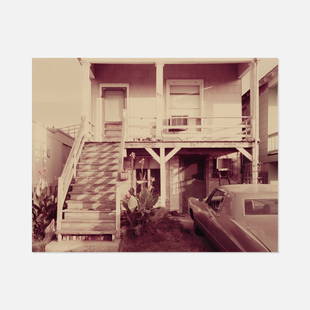
Sold2023Stephen Shore, M 1/2 Ave., Galveston, TexasUSA, 1976 c print 10” x 8” M 1/2 Ave., Galveston, Texas by Stephen Shore from the portfolio 'Twelve Photographs', published by The Metropolitan Museum of Art in an edition of 50. Signed anSee Sold Price
Sold2023Obsolete Galveston, Texas 6pt Constable Badge2.5" 6pt gold tone star badge, unmarked back.See Sold Price
Sold2019AN VINTAGE MAP, "Texas and Indian Territory," SECONDAN VINTAGE MAP, "Texas and Indian Territory," SECOND QUARTER 20TH CENTURY, color engraving on paper, showing counties, cities, rail lines, and rivers. 13.25" x 10.125"See Sold Price
Jun 23Schilb Antiquarian Rare Books1848 Emory Military Reconnaissance 1ed California MAP Indians Texas New Mexico$4(4 bids)
5 days LeftJasper52Islands in the Pacific Ocean. Hawaii. Phantom Jardines islands. THOMSON 1830 map$75
BonhamsMITCHELL (SAMUEL AUGUSTUS) A New Universal Atlas Containing Maps of the Various Empires, Kingdom...£1,300
Featured4 days LeftJasper521863 Johnson & Ward Map of the United States -- Johnson's New Military Map of the United States$140