Sold20151845 U.S. Coastal Survey Print NY Bay and HarborU.S. Coastal Survey Print, Map of New York Bay and Harbor and the Environs, published 1845, A.D. Bache Superintendent, overall 30-1/2 x 38-1/2""See Sold Price
Sold2023US WALL MAPS AND AERIAL VIEW OF NEW YORK CITYA lot of three antique and vintage wall maps of New York. The lot includes a 1914 map of New York bay and harbor, a D. Lambert Railing Co. color map of New York State, and an aerial view of Hudson RivSee Sold Price
Sold2016Map, New York Harbor, G. Mathiot, 1886This map depicts the New York Bay and Harbor area as of 1886, printed with color and with as accurate as possible scaling and measurements of depth given the time period. The top left denotes the yearSee Sold Price
Sold2018Large/scarce 1861 map of New York BayReserve Reduced! Large and scarce 1861 coastal map of New York City and its harbor. One of the earliest 19th century charts to depict New York City as we know it today. It shows Manhattan, Brooklyn anSee Sold Price
Sold2022Large lot of 1960s Nautical Chart Maps New York Harbor, Harlem River, Hudson River, Raritan RiverLarge lot of 1960s Nautical Chart Maps New York Harbor, Harlem River, Hudson River, Raritan RiverSee Sold Price
Sold2022(NEW YORK CITY.) Sanborn Map Company. Pier Map of New York Harbor.(NEW YORK CITY.) Sanborn Map Company. Pier Map of New York Harbor. Albumen aerial photograph of lower Manhattan to front pastedown, title-page, index, double-page hand-colored lithographed key map, anSee Sold Price
Sold2016Map of New York Bay. North America. 1839.Print of steel engraving titled „Plan de la baie de New-York“.Drawn by unknown.Engraved by Blondeau.From „Etats-Unis D‘Amerique by M. Roux de Rochelle. Published by Firmin didot freres. Paris.See Sold Price
Sold2023Weller, F. S. 1894 Antique Map. New York and EnvironsLithograph Map Published 1891-94 by Cassell & Co., London for "Cassell's Encyclopaedia A Storehouse of General Information" by Various Authors. Map by F. S. Weller. Folds as issued. Paper Size: 11 x 9See Sold Price
Sold20231914 Maritime Chart Of New York HarborUS Coast Survey Chart dated 1914. This is a nautical anchorage chart of New York Harbor, upper bay and narrows. This particular chart has areas marked where vessels were allowed to anchor in the bustlSee Sold Price
Sold2023Engravings by Henry Farrer & A.W. LangsterHenry Farrer, 1879 Original Etching "On New York Bay", A.W. Langster Engraving "Tonawanda Harbor Evening" approx 16" x 20"See Sold Price
Sold2022Group Lot of 7 Pieces of ArtGroup lot of (7) pieces of art depicting cottages, harbor scenes, New York Bay with lighthouse, and more. Also includes original art from Flavia Marotta. They measure from 9 to 13 inches tall by 10 toSee Sold Price
Sold20221828 MAP of New York City Suburbs Railroads New Jersey EC Bridgman Color1828 MAP of New York City Suburbs Railroads New Jersey EC Bridgman Color An impressive, 19th-century map of New York City and its surrounding environs. This E.C. Bridgman map is a huge map folded intoSee Sold Price
Sold2023Granville Perkins (American, 1830-1895) New York Bay, Seascape Oil PaintingDESCRIPTION: Granville Perkins (American, 1830-1895) Oil on canvas painting depicting the lower Bay of New York Harbor, signed and dated (Lower Left) "Granville Perkins, 1885" and at verso: "In The LoSee Sold Price
Sold2020Rasmusio and Gastaldi Map of Eastern Seaboard 160Giovanni Battista Rasmusio (1485-1557) and Giacomo Gastaldi (1500-1566), "La Nuova Francia," Venice, 1606. Woodcut map depicting the eastern seaboard of the United States and Canada from New York BaySee Sold Price
Sold2022[NEW YORK SCENES] -- CURRIER and IVES, publishers. City of New York and Environs, 1875. (G.1226). --[NEW YORK SCENES] -- CURRIER and IVES, publishersCity of New York and Environs, 1875. (G.1226). -- The Narrows, New York Bay. From Staten Island, n.d. (G.4760). 2 small-format lithographs with hand-coSee Sold Price
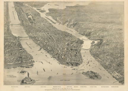
Sold2021New York Bay, 1897Bird’s-Eye View of New York City in 1897This small but intensely detailed map of the city of New York depicts a near snapshot of what could be seen from a rare objective-above. With Burroughs aSee Sold Price
Sold2019Hudson by Daylight MapTitle/Content of Map: Hudson by Daylight Map Date: 1878 © Cartographer: LINK, WILLIAM F. Size: 5.5Height - 99Width Publisher: WM. F. LINK from New York Bay to the head of tide water containing nameSee Sold Price
Sold20181984 NOAA New York Harbor Navigational ChartTitle/Content of Map: 1984 NOAA New Your Harbor Navigational Chart Issued for Statue of Liberty Centennial -- United States East Coast; New York - New Jersy; New York Harbor Date Printed: 1984, WashinSee Sold Price
Sold2023MAP: United States - East Coast. Thames River New York London Harbor Long Island to NorwichDescription: United States - East Coast Connecticut - New York. Thames River/ New York London Harbor Long Island to Norwich. Published at Washington D.C. US Department of Commerce, Environmental ScienSee Sold Price
Sold201713 1859 U.S. Coastal Survey MapsDESCRIPTION: Collection of thirteen 1859 United States coastal survey maps from a trigonometrical survey. Includes: St. Mary's River, Maryland; New York Bay and Hudson River; Port Royal Entrance of SoSee Sold Price
Sold2021CHARLES J. LUNDGREN (American 1911 – 1988) Oil onCHARLES J. LUNDGREN (American 1911 – 1988) Oil on Panel, Castle Garden and New York Bay, 1869, 1980. New York Tug accompanies a three masted schooner in New York Harbor. Signed and dated lower rightSee Sold Price
Sold2016Map, Hudson River, Rev. War, Sauthier, 1776At the top of the map is written: "A Topographical Map of Hudsons River, with the Channels Depth of Water, Rocks, Shoals, &c. and the Country Adjacent, from Sandy-Hook, New York and Bay to Fort EdwardSee Sold Price
Sold2021Hayward Map of New York City -- A Plan of the City ofTitle: Hayward Map of New York City -- A Plan of the City of New York & its Environs to Greenwich … Cartographer: J Hayward / Valentine's manual Year / Place: 1855, New York Map Dimension (in.): 24.See Sold Price
Sold20181813 but 1854 Grim's Map of New York CityTitle/Content of Map: 1813 but 1854 Grim's Map of New York City -- A Plan of the City and Environs of New York as they were in the Years 1742, 1743 and 1744 Drawn by D. G. in the 76th Year of his ageSee Sold Price
4 days LeftRail & Road AuctionsScandinavian-American Line Tin Lithograph Advertising Sign of Frederick VIII By Ferdinand Worms$170
May 15University ArchivesStatue of Liberty Inaugural Ceremony Invitation, October 28, 1886$300(1 bid)
4 days LeftRail & Road AuctionsAmerican Export Lines SS Independence Advertising Print By Frederick Hoertz$30
May 16Potter & Potter Auctions[NEW YORK CITY – PICTORIAL MAPS]. Group of 3 pictorial maps...$200(1 bid)


![[NEW YORK SCENES] -- CURRIER and IVES, publishers. City of New York and Environs, 1875. (G.1226). --: [NEW YORK SCENES] -- CURRIER and IVES, publishersCity of New York and Environs, 1875. (G.1226). -- The Narrows, New York Bay. From Staten Island, n.d. (G.4760). 2 small-format lithographs with hand-co](https://p1.liveauctioneers.com/197/264838/138100533_1_x.jpg?height=310&quality=70&version=1665664275)


![[CIVIL WAR] Union Deserters Jump Overboard (1 of 3)](https://p1.liveauctioneers.com/7226/325455/175168991_1_x.jpg?height=282&quality=70&version=1712370394)


![[NEW YORK CITY – PICTORIAL MAPS]. Group of 3 pictorial maps... (1 of 3)](https://p1.liveauctioneers.com/928/325952/175495562_1_x.jpg?height=282&quality=70&version=1712935174)


