Sold2019Two Maps by Thomas Kitchin (1718-1774), "Map of theTwo Maps by Thomas Kitchin (1718-1774), "Map of the countries on the South Sea from Panama to Guayquil," 1821, together with "West Indies agreeable to the most approved Maps and Charts," 1782, South SSee Sold Price
Sold2019Robertson & Kitchin 1795 Map. Panama, Ecuador etc"Map of the Countries on the South Sea from Panama to Guayquil" Copper Engraved Map Published 1795, London for "The History of America" by Dr. William Robertson. Drawn & Engraved by Thomas Kitchin. FoSee Sold Price
Sold2018Kitchin: Antique Map of Panama/Colombia/Ecuador, 1795Map: Map of the Countries on the South Sea, from Panama to Guayaquil Cartographer: Kitchin Place & Date: London / 1795 Size: 9 3/8" x 14 5/8" Condition: outline color; overall age toning; upper rightSee Sold Price
Sold2024A New and Exact Map of the Coast, Countries and Islands within the, limits of the South Sea CompanyA New and Exact Map of the Coast, Countries and Islands within the limits of the South Sea Company by Moll (London, 1711) "A New and Exact Map of the Coast, Countries and Islands within the limits ofSee Sold Price
Sold2023Print, Herman MollHerman Moll (British, 1654-1732), "A New and Exact Map of the Coast, Countries and Islands within ye Limits of ye South Sea Company, from ye River Aranoca to Tierra del Fuego, and from thence throughSee Sold Price
Sold2018Three Antique Mapswith The Countries and Islands Of The South Sea Company, 25 3/4" x 19 3/4" (sight) America Meridio Nalis, 15" x 20" (sight) Hispaniae, Novae Sivae, 14 1/2" x 20" (sight)See Sold Price
Sold2020Color pictorial map of Panama Mail Steam Ship routeHeading: (Panama Mail Steamship - color pictorial map) Author: Godwin, Harrison Title: The sea coastes of America shewing the ports of call of the Panama Mail Steamships as the country there aboutes iSee Sold Price
Sold20171773 Gentlemans Magazine Map Voyage South Seas Cpt CookFirst printing in original blue advertising wrapper of the Supplement issue of Gentleman's Magazine for the year 1773. Bound with the General Title and Preface and 26 pages, engraved folding plate shoSee Sold Price
Sold20231748 George Anson World Voyage 3 HUGE MAPS Spain South America Sea Navigation1748 George Anson World Voyage 3 HUGE MAPS Spain South America Sea Navigation George Anson was an 18th-century British Navy admiral who is noted for his important world voyage in which he circumnavigaSee Sold Price
Sold20211753 Fine Folding Map of the South SeasMap of the South Seas by Jacques Bellin, Paris, circa 1753. Entitled "Carte Reduite De la Mer Du Sud Pour Servir a l'Histoire generale des Voyages". Fine folding map, close trim to right margin. MeasuSee Sold Price
Sold2015Dutch Map of Panama & South America, circa 1630sJan Janssonius (Dutch, 1588-1664). "Firma et Novum Regnum Granatense et Popayan", published in Amsterdam c.1636, copperplate cartographical engraving with Dutch text to verso, inscribed below title caSee Sold Price
Sold2018North Sea countries. Rare Map of Scandanavia. BritishNorth Sea countries. Rare Map of Scandanavia. British isles to Greenland 1740-70's J.N. Bellin & J.F. La Harpe 14 1/2" x 19 1/3" Copperplate engraved. Published in Paris. From the 'Aberge de L'HistoirSee Sold Price
Sold2021Framed Map of the South China Sea c1760 Published byFramed Map of the South China Sea c1760 Published by French Cartographer Nicholas Bellin, this pictre has been framed in accordance with museum standards, Frame size H: W: 17.4 in. (43 cm)x W:15.2in.See Sold Price
Sold2017Gray's Antique Map of Countries Surrounding Black SeaMap: Gray's New Map of the Countries Surrounding the Black Sea Comprising European Turkey Southern Russia Asia Minor Etc. Publication Date: 1877 Authors: O.W. GRAY & SON, GRAY, FRANK A. Publisher: O.WSee Sold Price
Sold2018NORTH AMERICA.Texas Republic.Mexican California.RussianTITLE/CONTENT OF MAP: 'NORTH AMERICA, South to Panama.' The Republic of Texas is shown as an independent state as it existed between 1836 and 1845; it shows the US-Mexican border prior to the Mexican-See Sold Price
Sold2020NORTH AMERICA.Texas Republic.Mexican California.RussianTITLE/CONTENT OF MAP: 'NORTH AMERICA, South to Panama.' The Republic of Texas is shown as an independent state as it existed between 1836 and 1845; it shows the US-Mexican border prior to the Mexican-See Sold Price
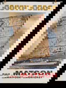
Sold2023Matson SS Mariposa South Seas Lithograph Travel Cruise PosterMatson Lines SS Mariposa SS Monterey South Seas Treasure Map Poster. Reads Matson's Treasure Route Through All The South seas, San Francisco, Los Angeles, Hawaii, Samoa, Fiji, Sydney, Auckland, TahitiSee Sold Price
Sold2024Matson SS Mariposa South Seas Lithograph Travel Cruise PosterMatson Lines SS Mariposa SS Monterey South Seas Treasure Map Poster. Reads Matson's Treasure Route Through All The South seas, San Francisco, Los Angeles, Hawaii, Samoa, Fiji, Sydney, Auckland, TahitiSee Sold Price
2017Gray: Map of Countries Surrounding the Black Sea, 1883Map: Gray's New Map of the Countries Surrounding the Black Sea: Comprising Turkey in Europe, and Part of Turkey in Asia, Greece (Hellas) Southern Russia, Etc... Publication Date: 1883 Authors: STEDMANSee Sold Price
Sold2018Vintage Hankie CollectionApprox. 40 vintage hankies including needlework, Pan American 1901, printed children's hankies, cloth maps of Japan and South China Sea and more.See Sold Price
Sold20221831 Teesdale Map of Southeast Asia -- Birman Empire & Countries South EastTitle: 1831 Teesdale Map of Southeast Asia -- Birman Empire & Countries South East Cartographer: H Teesdale Year / Place: 1831, London Map Dimension (in.): 15.8 X 12.9 in. This is a very nice map of sSee Sold Price
Sold2017Mitchell: Antique Map of South American Countries, 1869Map: New Granada Venezuela Peru Ecuador Argentina Date Printed: 1869 Cartographer: Augustus S. Mitchell Material/Medium: Paper Size: 12 1/4" x 15 1/4" Hand colored engraved map. Printed in PhiladelphiSee Sold Price
Sold2022Antique Map Print - Map of Pomerania - Map of Germany - South of the Baltic SeaAntique outline hand colored map from edition of Meyer’s world atlas, edited by Ludwig Ravenstein, published by Bibliographic Institute in 1872. Technique: Engraving. Place: Leipzig, Germany. SSee Sold Price
Sold201717th C. 1654 Capitana Shipwreck Silver Treasure Coins17th Century 1654 Capitana Shipwreck Silver Treasure Coins (two). Mid- 17th century flagship of the Armada del mar del sur (South Sea Armada) sailing from Peru to Panama. Coin - 2" diameter. Box - 1 7See Sold Price
5 days LeftAlbion AuctionsStieler, Adolf 1909 Antique Map. New Zealand - South Sea Islands, Pacific Australia Hawaii$5
4 days LeftJasper52THRACE & DACIA. European Turkey Romania Bulgaria Danube. 'Dace'. MALLET 1683 map$40
4 days LeftJasper52Countries round the Mediterranean. Soundings Telegraph cables. STANFORD 1904 map$60
4 days LeftJasper52Countries round the Mediterranean. Soundings Telegraph cables. STANFORD 1894 map$75
4 days LeftJasper52Countries round the Mediterranean. Soundings Telegraph cables. STANFORD 1894 map$75
4 days LeftJasper52Countries round the Mediterranean. Soundings Telegraph cables. STANFORD 1896 map$75
4 days LeftJasper52MEDITERRANEAN SEA. Submarine telegraph cables. steamship routes. LOWRY 1863 map$55
4 days LeftPotter & Potter AuctionsPOLAND, Edwin Christian (1903 – 1991). The Evergreen Playgr...$200
2 days LeftMynt AuctionsRare 1935 New York to San Francisco via Panama Canal Postcard to Waconia MN$330