Sold2020The Wonderground Map of London Town 1915 MacDonalLeslie MacDonald Gill (1884-1947), "The Wonderground Map of London Town," London, 1915. This highly detailed and eye-catching map was commissioned by the London Underground to entertain passengers waiSee Sold Price
Sold2022LONDON UNDERGROUND tube map diagram plan. First STINGEMORE edition 1925TITLE/CONTENT OF MAP: Underground Railways of London [694 11.5.25] This is the first edition of an Underground geographic map designed by F H Stingemore. It is one of the first designs not to show anySee Sold Price
Sold2018LONDON. Vintage Underground / Tube map 1933 old vintageTITLE/CONTENT OF MAP: 'Map of the Underground Railways of London' DATE: 1933 IMAGE SIZE: Approx 18.5 x 30.5cm, 7.25 x 12 inches (Medium) TYPE: Colour vintage street atlas map CONDITION: Good; suitableSee Sold Price
Sold2023Leslie MacDonald Gill (1884-1947) 'The Wonderground Map of London Town' c. 1924England, 20th century. Printed and Published by the Westminster Press, 11 Henrietta Street, Covent Garden, [1927]. Pictorial map printed in full color, 29” x 36.5” plus margins. The map waSee Sold Price
Sold2016MacDonald Gill (1884-1947) The County Bus Services MapMacDonald Gill (1884-1947) The County Bus Services Map and Central London Map, two reproductions of the original posters c.1922, printed for LT by John Bartholomew 1978 , each - 76 x 102 cm (2)See Sold Price
Sold2022London Tube Railways. 11 proposed new/extended Underground lines HMSO 1901 mapTITLE/CONTENT OF MAP: 'London tube railways 1901' This fascinating map, drafted by the Civil Engineer Sir Alexander Binnie in his capacity as Chief Engineer of London County Council, shows the developSee Sold Price
Sold2018CENTRAL LONDON TRANSPORT. Railways & underground tubeCENTRAL LONDON TRANSPORT. Railways & underground tube DATE: 1906 IMAGE SIZE: Approx 22.0 x 27.5cm, 8.5 x 10.75 inches (Medium); Please note that this is a folding map. TYPE: Antique colour travel mapSee Sold Price
Sold2023HAVANA. Vintage town plan. Railways & streetcar lines. Cuba. Caribbean 1923 mapHavana' by Sifton, Praed & Co. Ltd, St. James's St. London S.W. (1923). Vintage map, 18.5 x 15.0cm, 7.25 x 6 inches; Please note that this is a folding map. Additional Information: CAPTION PRINTED BELSee Sold Price
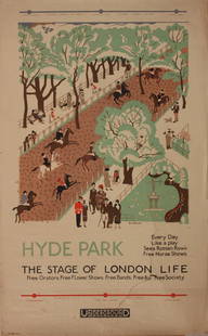
Sold2023Vintage PosterEdward Bawden (1903-1989) Hyde Park The Stage of London Life, original poster printed for the Underground (London Electric Railway) 1925 - 102 x 63 cm One the Bawden's first commercial design commissiSee Sold Price
Sold2017Cross (Joseph) - Cross's New Plan of London, 1836,from Canonbury to Camberwell, and from Hyde Park to East India Dock, updated to include the London and Birmingham railway, engraved map with full original hand-colouring, 665 x 1010mm., dissected andSee Sold Price
Sold2023Vintage PosterMacdonald Gill 1884-1947) The Country Bus Services Map, original poser printed for LT by Waterlow 1928 - 102 x127 cmSee Sold Price
Sold2024Stanford, Edward 1901 Large Map. British Isles - Railway MapLarge Folio Lithograph Map Published 1901, London for "Stanford's London Atlas of Universal Geography" by Edward Stanford. Centre fold as published. Paper Size: 29 x 21.5 inch (74 x 55cm) Very minor tSee Sold Price
Sold2024Cooke, George 1801 Antique Map. World Hemispheres by ArrowsmithEngraved J. Lodge after Aaron Arrowsmith. Copper Engraved Map Published 1801-07 by Macdonald & Son, London for "Modern and Authentic System of Universal Geography" By George A. Cooke. Folds as issued.See Sold Price
Sold2024Cooke, George 1801 Antique Map. Pacific Ocean - Australia etc (Fault)Copper Engraved Map Published 1801-07 by Macdonald & Son, London for "Modern and Authentic System of Universal Geography" By George A. Cooke. Folds as issued. Paper Size: 17.5 x 14.5 inch (45 x 37cm)See Sold Price
Sold2024Cooke, George 1801 Antique Map. ChinaCopper Engraved Map Published 1801-07 by Macdonald & Son, London for "Modern and Authentic System of Universal Geography" By George A. Cooke. Folds as issued. Paper Size: 12.5 x 10 inch (32 x 26cm) ApSee Sold Price
Sold2024Cooke, George 1801 Antique Map. India - HindoostanCopper Engraved Map Published 1801-07 by Macdonald & Son, London for "Modern and Authentic System of Universal Geography" By George A. Cooke. Folds as issued. Paper Size: 12.5 x 10 inch (32 x 26cm) ApSee Sold Price
Sold2024Cooke, George 1801 Antique Map. Turkey in EuropeCopper Engraved Map Published 1801-07 by Macdonald & Son, London for "Modern and Authentic System of Universal Geography" By George A. Cooke. Folds as issued. Paper Size: 12.5 x 10 inch (32 x 26cm) ApSee Sold Price
Sold2024Cooke, George 1801 Antique Map. ScotlandCopper Engraved Map Published 1801-07 by Macdonald & Son, London for "Modern and Authentic System of Universal Geography" By George A. Cooke. Folds as issued. Paper Size: 12.5 x 10 inch (32 x 26cm) ApSee Sold Price
Sold2024Cooke, George 1801 Antique Map. Turkey is AsiaCopper Engraved Map Published 1801-07 by Macdonald & Son, London for "Modern and Authentic System of Universal Geography" By George A. Cooke. Folds as issued. Paper Size: 12.5 x 10 inch (32 x 26cm) ApSee Sold Price
Sold2024Cooke, George 1801 Antique Map. AsiaCopper Engraved Map Published 1801-07 by Macdonald & Son, London for "Modern and Authentic System of Universal Geography" By George A. Cooke. Folds as issued. Paper Size: 12.5 x 10 inch (32 x 26cm) ApSee Sold Price
Sold2024Cooke, George 1801 Antique Map. FranceCopper Engraved Map Published 1801-07 by Macdonald & Son, London for "Modern and Authentic System of Universal Geography" By George A. Cooke. Folds as issued. Paper Size: 12.5 x 10 inch (32 x 26cm) ApSee Sold Price
Sold2024Cooke, George 1801 Antique Map. Russian EmpireCopper Engraved Map Published 1801-07 by Macdonald & Son, London for "Modern and Authentic System of Universal Geography" By George A. Cooke. Folds as issued. Paper Size: 13.5 x 10 inch (34 x 26cm) ApSee Sold Price
Sold2024Cooke, George 1801 Antique Map. Spain & PortugalCopper Engraved Map Published 1801-07 by Macdonald & Son, London for "Modern and Authentic System of Universal Geography" By George A. Cooke. Folds as issued. Paper Size: 12.5 x 10 inch (32 x 26cm) ApSee Sold Price
Sold2015Original Vintage PosterT Way (Thomas Robert 1861-1914) Twickenham Ferry Underground London United Tramways , printed for Electric Railway House by T Way July 1911 - 52 x 21.5 cmSee Sold Price
Featured4 days LeftJasper521814 Aaron Arrowsmith map. Israelites from Egypt to Canaan through the desert of Arabia Petraea$130
May 29Adam's AuctioneersFrank Brangwyn (Illus.) 'The Rubaiyat of Omar Khayyam' With colour illustrations and decorations b€0
5 days LeftForum AuctionsLondon.- River Thames.- Tombleson (William) Tombleson’s Panoramic Map of the River Thames and£260
1818 AuctioneersRailways and Engineering. Grover, J. W. - Estimates and Diagrams of Railway Bridges for Turnpike,£42
Jun 05TimeLine Auctions Ltd.Archaeological Books - Myths and Legends of Ancient Egypt and Other Titles.£5(1 bid)
5 days LeftPotter & Potter Auctions[NEWSPAPER]. [NELSON, Lord Horatio (1758-1805), subject]. T...$200
5 days LeftDoyle New YorkRussian Porcelain Plate from the Service of The Order of St. Alexander Nevsky$1,300(1 bid)
BonhamsA collected silver Hanoverian pattern table service of flatware various maker's and dates (Qty)£1,400
5 days LeftForum AuctionsLondon.- Langley (Edward, & Belch, William) Langley and Belch's New Map of London, engraved map,£600
May 30PropstoreSTAR WARS: THE EMPIRE STRIKES BACK (1980) - Untrimmed UK "Gone with the Wind" Style A Quad£8,000
Jun 06Freeman's | HindmanCLEMENS, Samuel Langhorne ("Mark Twain") (1835-1910). The Curious Republic of Gondour. New York:$200
3 days LeftBonhamsA group of six books and pamphlets, relating to the Sikh States of Patiala, Jind and Nabha Print...£1,200


![LONDON UNDERGROUND tube map diagram plan. First STINGEMORE edition 1925: TITLE/CONTENT OF MAP: Underground Railways of London [694 11.5.25] This is the first edition of an Underground geographic map designed by F H Stingemore. It is one of the first designs not to show any](https://p1.liveauctioneers.com/5584/263211/137236971_1_x.jpg?height=310&quality=70&version=1664917902)

![Leslie MacDonald Gill (1884-1947) 'The Wonderground Map of London Town' c. 1924: England, 20th century. Printed and Published by the Westminster Press, 11 Henrietta Street, Covent Garden, [1927]. Pictorial map printed in full color, 29” x 36.5” plus margins. The map wa](https://p1.liveauctioneers.com/7899/310285/166001628_1_x.jpg?height=310&quality=70&version=1700492487)


![[NEWSPAPER]. [NELSON, Lord Horatio (1758-1805), subject]. T... (1 of 2)](https://p1.liveauctioneers.com/928/328184/176813431_1_x.jpg?height=282&quality=70&version=1714496988)


![[MAGIC & ALLIED ARTS]. Group of 8 volumes in original and d... (1 of 1)](https://p1.liveauctioneers.com/928/329228/177514409_1_x.jpg?height=282&quality=70&version=1715272280)