Sold2020Aitken Revolutionary War Boston Map 1775Robert Aitken (1735-1808), "A New and Correct Plan of the Town of Boston," London: The Gentleman's Magazine, 1775. This map of Boston depicts the city early in the American Revolution, including the rSee Sold Price
Sold2023AMERICAN REVOLUTIONARY WAR MAP OF BOSTON, MASSACHUSETTSAMERICAN REVOLUTIONARY WAR MAP OF BOSTON, MASSACHUSETTS, uncolored engraving on paper, A New and Correct Plan of the Town of Boston and Provincial Camp, engraved by Robert Aitken (AmeriSee Sold Price
Sold2022(2) BOSTON REVOLUTIONARY WAR MAPS, CHARLESTOWN AND BUNKER HILLA Plan of the Action at Bunker Hill on the 17th of June 1775; engraved for Stedman's History of the American War; publ. by the auSee Sold Price
Sold2023First American Revolutionary War Battle Map, from Nathan Daboll, Freebetter's New-England Almanacks,American Revolution First American Printing of a Revolutionary War Battle Map Titled: "A VIEW of the Present Seat of War, at and near New-York." by Nathaniel Low, Printed by John Gill, Boston 1777-DatSee Sold Price
Sold2022Lot of 18th & 19th Century DocumentsA lot of 18th/19th century documents including a 1777 Revolutionary War Boston receipt, an 1814 New Haven militia letter, an 18th century will, five misc. items, Wear consistent with age. RM The item(See Sold Price
Sold2017Revolutionary War era chart of Delaware Bay and RiverTitle/Content of Map: Revolutionary War era chart of Delaware Bay and River Date Printed: 1779 Cartographer: Gentlemans Magazine Size (in): 9 x 7 Small antique chart of Delaware Bay and River. DerivedSee Sold Price
Sold20201786 1ed America Voyages of Chastellux MAPS Revolutiona1786 1ed America Voyages of Chastellux MAPS Revolutionary WAR French Washington “the first trustworthy record of life in the United States!” (Howes) François Jean de Chastellux was an 18th-centurSee Sold Price
Sold20191771 PAUL REVERE Engraved Masthead BOSTON GAZETTEColonial America 1771 Paul Revere Engraved Masthead for THE BOSTON GAZETTE Newspaper with Faneuil Hall "Lottery Scheme" August 26, 1771-Dated Pre Revolutionary War Colonial Boston, Newspaper, "THE BOSSee Sold Price
Sold2022[PRE-REVOLUTIONARY WAR]. The Boston Chronicle. Vol. I, No. 51. Boston, MA: Mein and Fleeming, 5[PRE-REVOLUTIONARY WAR]. The Boston Chronicle. Vol. I, No. 51. Boston, MA: Mein and Fleeming, 5 December 1768.  4pp., folio, 8 1/4 x 10 1/2 in. Disbound (scattered spotting, few stains, some toniSee Sold Price
Sold2022[PRE-REVOLUTIONARY WAR]. The Boston Gazette and Country Journal. No. 950. Boston, MA: Edes & Gill,[PRE-REVOLUTIONARY WAR]. The Boston Gazette and Country Journal. No. 950. Boston, MA: Edes & Gill, 21 June 1773.  4pp., folio, 9 1/4 x 14 1/2 in. Disbound (partial separation at centerfold, scattSee Sold Price
Sold2023IMPORTANT DATED 1780 REVOLUTIONARY WAR MAP HORN CANNONEER'S SIZE W/ FORTS, ALBANY, NY, SARATOGA,IMPORTANT DATED 1780 REVOLUTIONARY WAR MAP HORN CANNONEER'S SIZE W/ FORTS, ALBANY, NY, SARATOGA, ETC. 27" LONGSee Sold Price
Sold2017William Faden, rare Revolutionary War Map of NYWilliam Faden, rare Revolutionary War Map of NY, William Faden (British, 1749-1836), "A Plan of the Operations of the Kings Army under the Command of General Sr. William Howe, K.B. in New York and EasSee Sold Price
Sold2023Sauthier & Fadden Revolutionary War Map EngravingAn original 18th Century hand colored engraved topographical map, illustrated by Claude Joseph Sauthier (1736–1802) and published by William Faden (1749-1836), the latter serving as royal geogrSee Sold Price
Sold20241777 Revolutionary War Map America Septentrionalis1777 hand-colored map published by Homann Heirs, Nuremberg, showing the British colonies in North American, published in the midst of the American Revolution, entitled "America Septentrionalis a DominSee Sold Price
Sold2019Revolutionary War Map"A Plan of the Operations ... in New York and East New Jersey against the American Forces Commanded by General Washington" 29" x 20" (sight) Claude Joseph Sauthier, 1777See Sold Price
Sold20221777 Revolutionary War Map AMERICA SEPTENTRIKONALHistoric Maps 1777 AMERICA SEPTENTRIKONALIS... Homann Heirs 1777-Dated American Revolutionary War Period, Hand-Colored Engraved Map titled, "AMERICA SEPTENTRIKONALIS...," by Homann Heirs, Nuremberg, CSee Sold Price
Sold2023FIRST EDITION OF RARE REVOLUTIONARY WAR MAPCarte Nouvelle des Possessions Angloises en Amérique dressée pour l'intellegence de la guerre, Paris 1777, Maurille Antoine Moithey, engineer. Translation: New map of the English possessionsSee Sold Price
Sold2022UNUSUAL U.S. REVOLUTIONARY WAR MAP 1780Titled in both French and English "Seat of War in America." Date penciled on. Includes 1935 letter of provenance framed verso. Dimensions: (Frame) H 16" x W 21.75", (Sight) H 9.75" x W 15.5" ConditionSee Sold Price
Sold2017Homann Heirs: Antique Revolutionary War Map of the USTitle: 1777 Revolutionary War issue of Homann's map of the United States. America Septentrionalis a Domino d'Anville in Galliis edita nunc in Anglia Coloniis in Interiorem Virginiam... Map maker: HomaSee Sold Price
Sold2024Faden Revolutionary War Map of SaratogaFADEN, William (1749-1836). Plan of the Position which the Army under Lt. Genl. Burgoine took at Saratoga on the 10th of September 1777, and in which it remained till the Convention was signed. EngravSee Sold Price
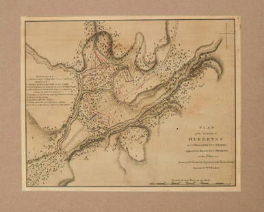
Sold2024Faden Revolutionary War Map of HubertonFADEN, William (1749-1836). Plan of the action at Huberton under Brigadier Genl. Frazer, supported by Major Genl. Reidesel, on the 7th July 1777. Drawn by P. Gerlach Deputy Quarter Master General. EngSee Sold Price
Sold2017Revolutionary War Map of the Battle of SaratogaAmerican Revolution 1780 Revolutionary War Map Engraved by William Faden 1780-Dated Revolutionary War, Hand-Colored Map entitled, “Plan of the Encampment and Position of the Army Under His Excelly.See Sold Price
Sold20211780 Faden Map of American Revolutionary War Battle inTitle: 1780 Faden Map of American Revolutionary War Battle in Vermont -- Plan of the Action at Huberton Under Brigadier Genl. Frazer, Supported by Major Genl. Reidesel, on the 7th July 1777 CartographSee Sold Price
Sold2017Revolutionary War MapMap, 18” x 11,” “Plan of the Siege of Charleston in S. Carolina" 1807, publishedC.P. Wayne, Philadelphia, withdrawn from book. Showing the location of downtown Charleston, Fort Sullivan (later nSee Sold Price
Jun 23East Coast Fine Arts LLC1777 US Revolutionary War Map French Brion de la Tour Theatre de Guerre$1,000
3 days LeftEarly American History Auctions1782 Boston, MA. and 1795 Alexandria,VA. Lot of Two International Financial Bills of Exchange$300
3 days LeftEarly American History Auctions1778 Revolutionary War Nathaniel Barber Signed, Acting Muster Master, Ex: Boston Tea Party$1,800
3 days LeftEarly American History AuctionsApril 8, 1779 Revolutionary War Newspaper, The Independent Chronicle, Boston + Identified + Content$400
Jun 13Swann Auction Galleries(NEW YORK CITY.) Group of 9 nineteenth-century maps of Manhattan,$600(1 bid)
3 days LeftEarly American History AuctionsJune 8, 1776 at Boston, Manuscript Document Signed by Artemas Ward as Commander-in-Chief$1,500
3 days LeftEarly American History AuctionsJune 22, 1775 PAUL REVERE Engraved KING PHILIP Bond Signed CAPT JOSEPH LEE, Boston TEA PARTY Patriot$18,000
2 days LeftFreeman's | Hindman[MAP]. SARTINE, Antoine Plan de la Barre et du Havre de Charles-Town...1778. RARE REVOLUTIONARY WAR$1,000(1 bid)
3 days LeftEarly American History Auctions1811 Patriots Henry Dearborn + James Lovell Signed Ships Customs Declaration for the Port of Boston$375
3 days LeftEarly American History AuctionsAugust 12, 1779 Boston Newspaper Independent Chronicle Battle of Stony Point, NY Report by Gen Wayne$1,500
7 days LeftJasper52Map of the Towns of Livingston Germantown and Clermont in the County Of Columbia.$45
3 days LeftEarly American History Auctions1859 First Edition Book, Excursion of the Putnam Phalanx to Boston, Charlestown and Providence...$80
Jun 12Jasper52Rhode Island, part of Connecticut & Massachusetts shewing… LODGE 1780 old map$500
Jun 12Jasper52A Topographical Map of the northn. part of New York Island… FADEN/STEDMAN 1794$3,200
Jun 12Jasper52A plan of the action at Bunkers Hill, on 17th June 1775… FADEN/STEDMAN 1794 map$2,000
3 days LeftEarly American History Auctions1778 British 52nd Regiment of Foot Clothing Returns Participated at Lexington + Concord, Bunker Hill$550
3 days LeftEarly American History Auctions1777 Massachusetts Council Orders Wood be Supplied to General Burgoyne and his Men held as Prisoner$1,200
3 days LeftEarly American History Auctions(1784) Independent Chronical and Universal Advertiser, Reprint Newspaper Masthead after Paul Revere$110
3 days LeftEarly American History Auctions3-Newspapers 1807 Columbian Centinel, 1917 Christian Science Monitor and 1933 Springfield Union$100(1 bid)
3 days LeftEarly American History Auctions1844 A Discourse Occasioned by the Death of Hon. William Prescott, LL. D., by Alexander Young$150
3 days LeftEarly American History AuctionsLot of Miscellaneous Printed Articles and Reproduction Souvenier Continental Army USA Design Buttons$100


![[PRE-REVOLUTIONARY WAR]. The Boston Chronicle. Vol. I, No. 51. Boston, MA: Mein and Fleeming, 5: [PRE-REVOLUTIONARY WAR]. The Boston Chronicle. Vol. I, No. 51. Boston, MA: Mein and Fleeming, 5 December 1768.  4pp., folio, 8 1/4 x 10 1/2 in. Disbound (scattered spotting, few stains, some toni](https://p1.liveauctioneers.com/197/250551/130129962_1_x.jpg?height=310&quality=70&version=1654185975)
![[PRE-REVOLUTIONARY WAR]. The Boston Gazette and Country Journal. No. 950. Boston, MA: Edes & Gill,: [PRE-REVOLUTIONARY WAR]. The Boston Gazette and Country Journal. No. 950. Boston, MA: Edes & Gill, 21 June 1773.  4pp., folio, 9 1/4 x 14 1/2 in. Disbound (partial separation at centerfold, scatt](https://p1.liveauctioneers.com/197/250551/130129963_1_x.jpg?height=310&quality=70&version=1654185975)


![[MAP]. SARTINE, Antoine Plan de la Barre et du Havre de Charles-Town...1778. RARE REVOLUTIONARY WAR (1 of 1)](https://p1.liveauctioneers.com/197/329395/177650540_1_x.jpg?height=282&quality=70&version=1715364962)


