Sold2018C.1850 Levasseur Map Amerique SeptentrionaleLevasseur Map with hand-colored engravings from the Atlas National Illustre' (French). Amerique Septentrionale. 19th Century. Measures approximately 14.5" x 20" sheet size. Unframed, loose and not gluSee Sold Price
Sold2023V. Levasseur MapVictor Levasseur, French, 1800-1870. A mid 19th century engraved map with hand-coloring, titled "Dept. de L'Aude". Very slight foxing. Image 17 1/4 x 12 1/2" high, in a contemporary composite frame wiSee Sold Price
Sold2018Levasseur's decorative North AmericaHeading: Author: Levasseur, Victor Title: Amérique Septentrionale Place Published: Paris Publisher:A. Combette Date Published: [c.1845] Description: Steel-engraved map, hanSee Sold Price
Sold2021A Mid 19th Century Map, Pennsylvania"A New Map of Pennsylvania with its Canals, Rail-Roads, Etc..." published by Thomas Cowperthwait and Co. Philadelphia. Hand colored. Dimensions: Sight is 12" x 14 1/2". Provenance: From a PhiladelphiaSee Sold Price
Sold2022Scarce 1st ed. Colton RR map of North CarolinaLovely example of North Carolina map from the first edition of Colton’s Atlas of the World. One of the few mid-19th century maps to show North Carolina independently—it was more often mappSee Sold Price
Sold2022Scarce 1850 railroad map of New York by CowperthwaitSharp and colorful map of New York State with railroads highlighted by hand in orange-red to make them stand out. It is a testament to the importance of rail travel in the mid-19th century. Maps issueSee Sold Price
Sold2022Rare J.H. Colton Map, Southern Regions, Antarctica, South PoleRare mid 19th Century map of Southern Regions, Antarctica, South Pole, The Southern Polar Regions by J. H. Colton, from an 1855 first edition, Colton's Atlas of The World. A rare look at Antarctic expSee Sold Price
Sold2018Mid-19th C Hunting Maps Royal HuntTWO folding early 19th century hunting maps: one for the Royal Hunt and the other for the Albrighton Hunt. Fine condition, each approx. 8 x 13”. Please note that this lot has a confidential reserve.See Sold Price
Sold2022Scarce 1846 map of Maryland and Delaware by MitchellStrikingly lovely map of Maryland and Delaware by perhaps the premier map producer of the mid-19th century. The map is centered on Washington, D. C., and extends eastward from Maryland to New Jersey aSee Sold Price
Sold2021Impressive 1854/56 Colton map of LouisianaBeautiful map of Louisiana with 1854 date. From Colton’s 1856 Atlas of the World, one of the best American atlases of the mid-19th century. Detailed map with decorative border, colored by parish andSee Sold Price
Sold2021Antique Framed Mounted Color Lithograph of Hudson 19 C.Antique Framed Mounted Color Lithograph of Hudson 19 C. Titled "Amerique Septentrionale etat de New York," by "L. Fabatier." View is of a stormy Hudson river with many sailboats and buSee Sold Price
Sold2023Excellent 2-pg. antique map of Palestine - 1888Map of the Holy Land depicting the land of Israel during the mid 19th century. The map shows the boundaries of the 5 Roman Divisions Judea Samaria, Perea, the Decapolis, and Galilea. The map extends nSee Sold Price
Sold2021Civil War era county map of Georgia & AlabamaS. Augustus Mitchell published some of the nicer atlases during the mid-19th century in America. Maps from these atlases are desirable documents showing what the different states looked like at the tiSee Sold Price
Sold2019Rare 1st ed. map of world diseases, c1848World map showing the spread of diseases across the globe in mid-19th century. Three inset maps show diseases in North America, the spread of cholera throughout the world and South Africa. Charts andSee Sold Price
Sold2021Levasseur Map, "Amerique Septentrionale" ca. 1845**Originally Listed At $275** Cartographer: Victor Levasseur (French, 1800-1870). Printer: Joseph Rose Lemercier (French, 1803-1887). "Amerique Septentrionale" - steel engraving with hand coloring. IsSee Sold Price
Sold2023Highly collectible 1860 RR map of Texas, S. A. Mitchell, Jr.One of the most attractive atlas maps of Texas to appear in the mid-19th century. This authentic antique map (160 years old) was published when the Civil War was at its height. It shows the region froSee Sold Price
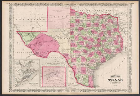
Sold2023Excellent example of Johnson’s Texas, 1866Authentic and impressive vintage map of Texas. One of the more collectible maps to be produced in the mid-19th century. A highly desirable map that details the state in full. Shows the elevated TableSee Sold Price
Sold2021Schotte and Co. mini terrestrial globeSchotte and Co. mini terrestrial globe, Mid-19th c., France, hand-tinted map engraving over papier-mache, rotating on turned wood stand, signed in engraving "Globe Schotte de Berlin revu et corrige paSee Sold Price
Sold2017Amerique Septentrionale Victor Levasseur MapAmerique Septentrionale. Maker: Victor Levasseur. Date: Ca. 1845. Size: sheet 14.5" x 20", printed area 11" x 17", Map image 8" x 7". The Atlas Universel Illustre by Victor Lavasseur is one of the lasSee Sold Price
Sold2017Levasseur Map of Amerique Septentrionale, 1861Title: 1861 Levasseur Map of North America, Texas Republic - Amerique Septentrionale Cartographer: V. Levasseur Published: 1861 Paris Measurements: 13x 16 in. This strikingly decorative map of North ASee Sold Price
Sold2016Levasseur: Map of Amerique Septentrionale 1850Map: Amerique Septentrionale Maker: Levasseur Date ca. 1850 Size: 12.25 x 17 inches From the last great decorative atlas with the Republic of Texas outlined in blue. Original outline color No Reserve:See Sold Price
Sold201813 Maps of Canada mid 19th Century13 Maps of Canada mid 19th Century-- Dimensions: largest 26.5x 16 - smallest 12.25x15.25 inches.---See Sold Price
Sold2022Exceptional 1864 RR map of Texas, S. A. Mitchell, Jr.One of the most attractive atlas maps of Texas to appear in the mid-19th century. This nearly 160-year-old map--published during the height of the Civil War--shows the region from western New Mexico tSee Sold Price
Sold2024The Kingdom of Naples or The Two Sicilies, 1850Lovely example of the Mitchell mid-century map of southern Italy. The Mitchell firm became the leading American producer of maps in the mid-19th century, which was carried on by Samuel Augustus MitcheSee Sold Price
3 days LeftJasper521758 MAP PARTIE DE LA MER GLACIALE contenants La Nouvelle Zemble RUSSIA antique$55
4 days LeftHannam's Auctioneers LtdA MID 19TH CENTURY CONTINENTAL GRAND TOUR MARBLE MICRO MOSAIC PAPERWEIGHT. 66.2 grams. 5 cm x 3.75 c£5
3 days LeftLoon EstatesLewis Morris Rutherfurd, First Quarter Moon 19th C. Glass Lantern Slide $65(4 bids)
Jun 23East Coast Fine Arts LLCHeinrich Funk Stuttgart Germany 19th C Watercolor Alpine Landscape Listed$8,000
1 day LeftRapid Estate Liquidators and Auction Gallery"A False Alarm on the Road to Gretna" C B Newhouse$95
5 days LeftJeffrey S. Evans & AssociatesJ.B. AKIN, DANVILLE, KENTUCKY RETAILED COIN SILVER PITCHER$500
5 days LeftJeffrey S. Evans & AssociatesPOINDEXTER, LEXINGTON, KENTUCKY COIN SILVER JULEP CUP / BEAKER$250(1 bid)
5 days LeftJeffrey S. Evans & AssociatesW.R. EVANS, CINCINNATI, OHIO OR COVINGTON, KENTUCKY COIN SILVER JULEP CUP / BEAKER$160(2 bids)


![Levasseur's decorative North America: Heading: Author: Levasseur, Victor Title: Amérique Septentrionale Place Published: Paris Publisher:A. Combette Date Published: [c.1845] Description: Steel-engraved map, han](https://p1.liveauctioneers.com/642/127929/65081039_1_x.jpg?height=310&quality=70&version=1537227236)