Sold2021Lapie - Carte de Etats Unis d’Amérique du Canada, duArtist: Lapie Title: Carte de Etats Unis d’Amérique du Canada, du Nouveau Brunswick et d’une partie de la Nouvelle Bretagne Description: Lapie - Carte de Etats Unis d’Amérique du Canada, du NoSee Sold Price
Sold2019Philomé Obin (Haitian, 1892-1986), , Untitled (BattlePhilomé Obin (Haitian, 1892-1986) Untitled (Battle Scene) Signed, located 'Cap-Haitien' bottom right and inscribed 'Escarmouche entre les hommes du Gal Valev St Amour avec les Marines de Etats Unis.See Sold Price
Sold202119th Century Map of MemphisPLAN DE LA VILLE DE MEMPHIS (ETATS-UNIS) 40,000 HABITANTS pen and ink with watercolor hand drawn drainage system map, circa 1870. Depicts a grid street plan of the city of Memphis with labeled streetSee Sold Price
Sold2022(CIVIL WAR.) Jean-Rodolphe Mayer. Nouvelle Carte des Etats-Unis de l'Amerique du Nord… 2de(CIVIL WAR.) Jean-Rodolphe Mayer. Nouvelle Carte des Etats-Unis de l'Amerique du Nord… 2de Edition. Large hand-colored lithographed map of the United States with a keyed reference table numberinSee Sold Price
Sold2019Les Etats Unis de I'Amérique Septentrionale, partieTITLE/CONTENT OF MAP: 'Les Etats Unis de I'Amérique Septentrionale, partie Occidentale [The United States of North America, western part]' The top image on the right hand side shows the entire map. TSee Sold Price
Sold2023"Carte De La Partie Nord, Des Etats Unis, de L'Amérique Septentrionale" by Rigobert Bonne. Paris,“Carte De La Partie Nord, Des Etats Unis, de l'Amerique Septentrionale” by Rigobert Bonne, Ca. 1780s. This post-revolutionary war map features a detailed overview of the mid-Atlantic regioSee Sold Price
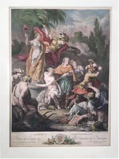
Sold2022[CONSTITUTION] DE LA ROCHEFOUCAULD D'ENVILLE, LOUIS ALEXANDRE (Duc de), translator. Constitutions[CONSTITUTION] DE LA ROCHEFOUCAULD D'ENVILLE, LOUIS ALEXANDRE (Duc de), translator. Constitutions des Treize Etats-Unis de L'Amerique. Philadelphia and Paris: [printed for La Rochefoucault and BenjamiSee Sold Price
Sold2024BEN. FRANKLIN CONSTITUTIONS DES TRIEIZE ETATS 1783Constitutions Des Treize Etats-Unis de l'Amerique. Printed 1783 by D. Pierres, Paris. Contains the first printed appearance of the Great Seal of the United States designed by Benjamin Franklin. The FrSee Sold Price
Sold2018Map, United States, 1784, first map of the nationMap, United States, 1784,"Carte Des Etats-Unis De L'Amerique Suivant le Traite de Paix de 1783. Dediee et Presentee A.S. Excellence M. Benjamin Franklin Ministre Pleinipotentaire des Etats-Unis", theSee Sold Price
Sold2021Antique French Map of United States- Etats-Unis De L'Amerique Septentrionale Avec Les Isles Royale, De Terre Neuve, De St. Jean, L'Acadie &c.; Hand-colored; Ches Boudet Imprimeur du Roi; Paris; undated (circa 1785). One of the early maSee Sold Price
Sold2016L'Amerique Septentrionale, F. Delamarche 1785Title: Etats-Unis De L'Amerique Septentrionale Avec Les Isles Royale, De Terre Neuve, De St. Jean, L'Acadie Subject: United States/American Revolution Maker: F. Delamarche Date: 1785, Paris Size: 18.7See Sold Price
Sold2023Antoine BOREL: Color Engraving by Le VasseurExtremely rare, original 1778 engraving titled "L'Amerique Independante; Dediee au Congres des Etats Unis de l'Amerique" [Independent America; dedicated to the Congress of the United States of AmericaSee Sold Price
Sold2018Buchon: Antique Map of USA territorial developmentTITLE/CONTENT OF MAP: 'Carte de l'adjonction progressive des divers états au territoire et à l'union constitutionelle des États-Unis de l'Amérique du Nord 1825' This fascinating map shows the terrSee Sold Price
Sold2022c. 1788 French Map of the Eastern United StatesHistoric Maps c. 1788 Map, "Les Etats Unis de L'Amerique Septentrionale, Partie Orientale" (Eastern Part of the Northern United States of America) by M. (Rigobert) Bonne c. 1788 Map titled, "Les EtatsSee Sold Price
Sold202118TH CENTURY FRENCH MAP OF SOUTHEASTERN USRigobert Bonne (French, 1727-1794). "Carte De la Partie Sud Des Etats Unis De L'Amerique Septentrionale" -circa 1780, engraving. Provenance: From the Lifetime Collection of Billy S. Arant, Jr., ChattaSee Sold Price
Sold20211800 Weld Map of Northern United States and Great LakesTitle: 1800 Weld Map of Northern United States and Great Lakes -- Partie des Etats-Unis de L'Amerique Septentrionale Cartographer: I Weld Year / Place: 1800, Paris Map Dimension (in.): 16.1 X !8.2 in.See Sold Price
Sold2019Two Maps by Rigobert Bonne (1727-1794, Paris), Isles deTwo Maps by Rigobert Bonne (1727-1794, Paris), Isles de Cuba et de Jamaiqe, 1750; together with Les Etats Unis de L'Amerique Septentrionale les Royale de Terre Neuve, de St. Jean et L'Acadie; et partiSee Sold Price
Sold2017E.F. Delamarche, French Framed Map"Etats-Unis de L'Amerique." Approx. 18" x 23" sight, 22 1/2" x 28 1/2" framed. (6215) Yellowing. Damage to glass.See Sold Price
Sold2016Tanner map of west 1852 in French pamphetHeading: Author: Tanner, Henry Schenck Title: Carte Des Nouvelle Etats et Territoires annexés aux Etats-Unis Extrait de la carte Génerale des Etats-Unis Publiée New York en 1851 par H. S. Tanner PSee Sold Price
Sold2018Engraved map of Canada and United StatesCarte de la Region Orientale des Etats-Unis et de la dominion du Canada, 19th century, engraved map with hand coloring, designed by A. Brue, overall (with frame): 19.5"h x 25"wSee Sold Price
Sold2023Two Vintage 1960s European Art Exhibition PostersTwo Post-War modern exhibition posters: 1) "Etats-Unis Scultures de XX Siecle" exhibition at Musee Rodin, Paris, 1965, published by Les Presses Artistiques, featuring a sculpture by David Smith. [OverSee Sold Price
2020Nall, esposition de Gravures et de dessins, FondationNall, esposition de Gravures et de dessins, Fondation des Etats-Unis, 5 August-9 June 1972, offset, cm 60,5x39.See Sold Price
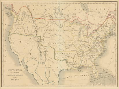
Sold2023EUSTACHE-HYACINTHE LANGLOIS (1777-1837) A MEXICAN TEXAS MAP, "Etats Unis et Partie de L'AméEUSTACHE-HYACINTHE LANGLOIS (1777-1837) A MEXICAN TEXAS MAP, "Etats Unis et Partie de L'Amérique Anglaise et du Mexique," PARIS, CIRCA 1830, lithograph on cream wove paper with hand color, probabSee Sold Price
Sold2017Tardieu: Antique Map of Northern U.S & Canada, 1798Map: Carte de la Partie Septentrionale des Etats Unis comprenant le Canada Cartographer: Chanlaire & Mentelle / Tardieu Place & Date: Paris / 1798 Size: 16 3/4" x 13" Condition: outline color; mild frSee Sold Price
Jun 14DuMouchellesRigobert Bonne (French, 1727-1794) Hand Colored Engraving Ca. 18th Century, Les Etats Unis De$50
BonhamsHERMES Paris. Cendrier en porcelaine 'Early America'. D'après le carré dessiné pa...€150
22 hrs LeftRapid Estate Liquidators and Auction GalleryPuissance Militaire Etats Unis D'Amerique Hardcover$90
4 days LeftJasper521719 Chatelain Map of the Adriatic and Venice Republic -- Carte de Geographie des Differents Etats$190
Jun 04Freeman's | HindmanManuel Azadigian (Armenian/American, 1901-1924) - Fontaine de l'Observatoire, Paris$1,000
5 days LeftJasper52Extremité Meridionale de l'Amérique Tierra del Fuego Magellan Str BONNE 1788 map$35
4 days LeftJasper521719 Chatelain Map of Russian Empire -- Carte Generale des Etats du Czar Empereur de Moscovie…$320
6 days LeftArt Research ParisALESSANDRO GUERRIERO (NÉ EN 1920) & ALCHIMIA (ÉDITEUR) ALESSANDRO GUERRIERO (NE? EN 1920) &€3,000
2 days LeftMynt AuctionsOlivia De Berardinis Licks from the Licorice Suite L/ED Signed and Numbered$10


![Les Etats Unis de I'Amérique Septentrionale, partie: TITLE/CONTENT OF MAP: 'Les Etats Unis de I'Amérique Septentrionale, partie Occidentale [The United States of North America, western part]' The top image on the right hand side shows the entire map. T](https://p1.liveauctioneers.com/5584/147595/74587359_1_x.jpg?height=310&quality=70&version=1565730371)

![[CONSTITUTION] DE LA ROCHEFOUCAULD D'ENVILLE, LOUIS ALEXANDRE (Duc de), translator. Constitutions: [CONSTITUTION] DE LA ROCHEFOUCAULD D'ENVILLE, LOUIS ALEXANDRE (Duc de), translator. Constitutions des Treize Etats-Unis de L'Amerique. Philadelphia and Paris: [printed for La Rochefoucault and Benjami](https://p1.liveauctioneers.com/292/250642/130213472_1_x.jpg?height=310&quality=70&version=1654271664)