Sold2024EARLY 18TH C. MAP OF ITALY, FRAMED"Italia iam Tota Principes in suas Partes accuratius distincta hisee, praeter caeteras adjunximus Majerum ejus Insularum Siciliam . . .", by Peter Schenk, Amsterdam, ca 1700, handcolored copperplate eSee Sold Price
Sold2020Guillaume de L'Isle and Peter Schenk MapGuillaume de L'Isle and Peter Schenk "L'Amerique Septentrionale Dressee sur les Observations...", Amsterdam, Pierre Schenk, 1708, hand-colored engraved map, 17 1/2 in. x 23 in., matted and framed ProvSee Sold Price
Sold2019Schenk Map of RussiaSCHENK, Petrus (1660-1711). La Russie Blanche Moscovie... Engraved map with original color. Amsterdam, c. 1700. 21 1/8" x 25" sheet. Handsome map showing the extent of the Russian Empire in Europe. ThSee Sold Price
Sold20201750 c. Schenk Map of Eastern Germany Centered onTitle: 1750 c. Schenk Map of Eastern Germany Centered on Dresden -- Dem Durchlauchtigsten Fursten und Herrn Herrn Friedrich Augusto... Cartographer: P Schenk II Year/Place: 1750 c., Amsterdam Size: 19See Sold Price
Sold2018Celestial MapPlanisphaerivm Sive Orbivm Mvn 17" x 20 1/2" (image) Peter Schenk, Amsterdam 18th centurySee Sold Price
Sold2018Schenk and Valk: BermudaReserve Reduced! Map Title: Mappa Aestivarum Insularum, alias Bermudas Cartographer: Schenk and Valk Place / Date: Amsterdam / 1700 (c.) Size: 19 7/8" x 15 1/8" Condition: contemporary color; overallSee Sold Price
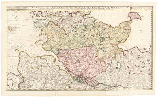
Sold2016Large map of Holstein, Germany 1720Heading: Author: Visscher, Nicolas Title: Holsatiae Ducatus Vernadule das Hertzogtum Holetein... Place Published: Amsterdam Publisher:Pieter Schenk, Jr. Date Published: c.1720 DescriptSee Sold Price
Sold2017Antique Engraved Map of Oxfordshire, England. c.1670sMap of Oxfordshire c.1670s by Gerard Valck (1651-1726) & Pieter Schenk (1660-1711) of Amsterdam, between 1670 and 1690. . Title. Oxonium comitatus vulgo Oxfordshire. Amstelaedami (Amsterdam) apud GeraSee Sold Price
Sold2022Peter Haller, MountainsPeter Haller Mountains c. 1955oil on pressboard 8 h × 10 w in (20 × 25 cm) Signed to lower right 'Haller'. This work will ship from Wright in Chicago, Illinois.See Sold Price
Sold2019Antique Map of AfricaCarte Des Costes de L'Afrique. Map by Mortier, Amsterdam, c. 1700. 24 1/2" x 20 1/2".See Sold Price
Sold2019France Antique Map & View, 17th C.Descriptio Veromanduorum, Antique map, Blaeu, Amsterdam, mid 17th C. W/ view Mommedy on 2 separate sheets, engraving by Israel Silvestre, 1669. 19 1/2" x 26 1/4".See Sold Price
Sold2017Vintage Metallic Paper Peter Shenk Map of WorldVintage Metallic Gold Foil Embellished Paper Shenk Map of the World, with a reverse painted black mat on the frame's glass. Copy of an 18th century world map by Peter Schenk the elder (1645-1715). FraSee Sold Price
Sold202216TH C. MAP OF AMSTERDAM BY BRAUN & HOGENBERG"Amstelredamum, Nobile Inferioris Germaniae Oppidum (..)" by Frans Hogenberg (1535-1590) / Georg Braun (1541-1622). Handcolored copperplate engraving, perspective map with buildings, from the first paSee Sold Price
Sold2018Bleau Map of AsiaBLAEU, Willem Janszoon (1571-1638). Asia Noviter Delineata…Engraved map with original hand color. Amsterdam, c. 1618-1650. 20 x 24 inches sheet, 25 1/8 x 21 3/8 inches framed This is one of the mostSee Sold Price
Sold2016CARTE PARTICULIERE DE VIRGINIE, MARYLAND, PENNSYLVANIA;CARTE PARTICULIERE DE VIRGINIE, MARYLAND, PENNSYLVANIA; ALEXIS-HUBERT JAILLOT (1632-1712), ENGRAVED HAND COLORED MAP, AMSTERDAM AND PAIRIS, PIERRE MORTIER, C.1693-1710 (AN IMPORTANT CHART OF THE MID-ASee Sold Price
Sold2024Six Maps including Visscher's Map of America[SIX MAPS] 1. VISSCHER, Nicolas (1618-1679). Novissima et Accuratissima Totius Americae descriptio. Engraved map with original hand color. Amsterdam, c. 1677. 20" x 24" visible, 29 1/2" x 33 1/2" framSee Sold Price
Sold2017De Wit Map of AfricaTotius Africa Accuratissima Tabula. Frederick de Wit (1629/1630-1706). Engraved map with original hand color. Amsterdam, c. 1660. 19 1/4 x 23 inches visible, 24 3/4 x 28 1/2 inches framedSee Sold Price
Sold2024Blaeu Map of the Amazon Region, BrazilBLAEU, Willem Janszoon (1571-1638). Guiana Siue Amazonum Regio. Engraved map with original hand color. Amsterdam, c. 1640. 18 1/2" x 22 3/4" sheet.See Sold Price
Sold2024Van Loon Map of the Guaiana and BrazilVAN LOON, Johannes (c. 1611-1686). Pascaerte van de cist van Guaiana oste de Wilde Custen't Noorder deel van Brazil... Engraved map with original hand color. Amsterdam, c. 1666. 18" x 22 1/4" sheet.See Sold Price
Sold2020CHATELAIN, H. [North America], [1720]Chatelain, H. DRESSEE SUR LES PLUS NOUVELLES OBSERVATIONS DE MESSIEURS DE L’ACADEMIE... [Amsterdam, c.1720].Engraved map, outline colour, folds and minor imperfections, small loss affecting 4 lSee Sold Price
Sold2017Hand Colored 'Edenburg, Scotland' MapHand Colored 'Edenburg, Scotland' Map c.1640, Amsterdam, a new description of the shyres Lothian and Linlitqvo, mapmaker Timothy Pont, printer Henricus Hondius Height: 14.00 inches, Width: 21.00 incheSee Sold Price
Sold2021De Witt. Angliae Regni et Walliae Principatus.[England] de Witt, Frederick (1630-1706). "Accuratissima Angliae Regni et Walliae Principatus." Amsterdam. c.1680. Copperplate engraved map. Hand colored cartouche and bordering. Shows most of the BriSee Sold Price
Sold2023De Wit Map of Zeeland, HollandDE WIT, Frederick (c. 1630-1706). Comitatus Zelandiae tabula... Engraved map with original hand color. Amsterdam, c. 1680. 21 1/2" x 24 3/8" sheet, approx. Antique Map of Zeeland, Netherlands showingSee Sold Price
Sold2023Visscher Map of Middleburgh, HollandVISSCHER, Nicolas II (1649-1702). Untitled [Middelburgh] Engraved map with original hand color. Amsterdam, c.1690 21 1/2" x 24 3/8" sheet. Antique Map showing the then Island of Middleburgh in HollandSee Sold Price
Jun 15Riverfront AuctionsC. 1730 Map of North Rhine-Westphalia, Germany after N. Sanson by Covens and Mortier$5
7 days LeftJasper52WEST AFRICA Explorers' routes Senegal Ashanti. Mountains of Kong. SDUK 1857 map$30
7 days LeftJasper52WEST AFRICA I Explorers' routes Senegal Ashanti Ivory Gold Coast. SDUK 1851 map$40
7 days LeftJasper52WEST AFRICA explorers' routes. Beaufort Gray Park Dochard Caillie. SDUK 1874 map$40
BonhamsAFRICA DE WIT (FREDERICK) Totius Africae Accuratissima Tabula,Amsterdam, Frederick de Wit, [c.16...£10
BonhamsEAST AFRICA DE WIT (FREDERICK) Occidentalior Tractus Indiarum Orientalium a Promontorio Bonae Sp...£300
Jun 12Quittenbaum Kunstauktionen GmbHPeter Hoogeboom (1961 Leiden - lives in Amsterdam), Necklace 'Slokkies', 1996€800


![Six Maps including Visscher's Map of America: [SIX MAPS] 1. VISSCHER, Nicolas (1618-1679). Novissima et Accuratissima Totius Americae descriptio. Engraved map with original hand color. Amsterdam, c. 1677. 20" x 24" visible, 29 1/2" x 33 1/2" fram](https://p1.liveauctioneers.com/1968/314554/168606424_1_x.jpg?height=310&quality=70&version=1704142666)


![CHATELAIN, H. [North America], [1720]: Chatelain, H. DRESSEE SUR LES PLUS NOUVELLES OBSERVATIONS DE MESSIEURS DE L’ACADEMIE... [Amsterdam, c.1720].Engraved map, outline colour, folds and minor imperfections, small loss affecting 4 l](https://p1.liveauctioneers.com/1124/187577/94368858_1_x.jpg?height=310&quality=70&version=1607095126)

![De Witt. Angliae Regni et Walliae Principatus.: [England] de Witt, Frederick (1630-1706). "Accuratissima Angliae Regni et Walliae Principatus." Amsterdam. c.1680. Copperplate engraved map. Hand colored cartouche and bordering. Shows most of the Bri](https://p1.liveauctioneers.com/179/209052/106367558_1_x.jpg?height=310&quality=70&version=1624651037)

![Visscher Map of Middleburgh, Holland: VISSCHER, Nicolas II (1649-1702). Untitled [Middelburgh] Engraved map with original hand color. Amsterdam, c.1690 21 1/2" x 24 3/8" sheet. Antique Map showing the then Island of Middleburgh in Holland](https://p1.liveauctioneers.com/1968/297676/158406682_1_x.jpg?height=310&quality=70&version=1690906360)


