Sold2022COVARRUBIAS, Miguel (1904-1957). The Covarrubias Map of Ame...COVARRUBIAS, Miguel (1904-1957). The Covarrubias Map of America. 1942. Philadelphia: Edward Stern & Co. Pictorial map of the United States, mounted on board, depicting Indigenous peoples, farmers, shiSee Sold Price
Sold2022FLICK, Alexander C. -- PAINE, Paul M. A Map of the History ...FLICK, Alexander C. -- PAINE, Paul M. A Map of the History of New York State. 1928. New York: R.R. Bowker Co. Historical pictorial map of New York with insets of Old New York, Niagara, Tip of Long IslSee Sold Price
Sold2023MOSS, Ira. Pictorial Wildlife and Game Map of the United St...MOSS, Ira. Pictorial Wildlife and Game Map of the United States. 1956. A.R. Gellman & Co/Shorewood Press. Color pictorial map filled with illustrations of the birds and animals of each state. Shaded iSee Sold Price
Sold20191961 General Drafting Co./Esso Civil War Pictorial MapTitle: 1961 General Drafting Co./Esso Civil War Pictorial Map of Battles -- A Pictorial Map Showing Historical Shrines and Battlefields of the Civil War 1861-1865 Date: 1961, Convert Station, NJ CartoSee Sold Price
Sold2023Lake Pend Oreille Pictorial Map 1956 by M. McLeanFeatured in this lot is an in depth pictorial map of Lake Pend Oreille in Bonner and Kootenai Co., Idaho, USA. Drawn and compiled by Marie McLean in 1956 and published by the McLean Studio, Glengary BSee Sold Price
Sold2021Charles W. Smith, Pictorial Map of Virginia"A Historical Map of Virginia" by artist Charles William Smith, (1893-1987, American,) copyrighted 1930 by Charles W. Smith, Offset lithography by Garrett & Massie, Inc., Richmond, Virginia. CopiouslySee Sold Price
Sold2020Pictorial map of Dude Ranches of the WestHeading: (Sportsman's...) Author: Blakeman, T.G. Title: The Sportsman's Dude Ranch Map Place Published: Boston Publisher:The Sportsman Publishing Co. Date Published: 1934 Description: <See Sold Price
Sold2023Pictorial map of Washington StateHeading: (Washington) Author: Herman, John F. & Chark Teegarden Title: A Pictorial Map of Washington: The Evergreen State"" Place Published: Seattle, WA Publisher:Ridgway Litho. Co. Date PublisheSee Sold Price
Sold2020Rare pictorial map of Oakland and S.F. BayHeading: (California - Oakland, San Francisco, etc.) Author: Lundy, Fred Title: San Francisco Bay. (with) part of San Francisco and Oakland Place Published: Oakland, CA Publisher:Tribune Publishing CoSee Sold Price
Sold2022RARE PICTORIAL MAP OF CAPE ANN & THE NORTH SHOREMounted to board. Designed by Errol W. Goff for Houghton Mifflin Co Boston MA 1934. 31 3/8 x 36 1/2 inches. Condition: Good. Frame slightly bowed.See Sold Price
Sold2023Pictorial map of western WashingtonHeading: (Washington) Author: Title: Good Natured Map - Shrine Playground - Seattle Washington Place Published: Seattle Publisher:Farwest Lithograph & Printing Co. Date Published: 1936See Sold Price
Sold2018Vintage Polar Projection of WWII World Pictorial MapTitle/Content of Map: 1943 Alcoa Aluminum Polar Projection of World at World Pictorial Map -- Global Map for Global War and Global Peace Date Printed: 1943 Cartographer: Alcoa Aluminum Co. Size: 24.4See Sold Price
Sold2018Pictorial Map of the American Continent, 1940Title/Content of Map: Pictorial Map of the American Continent Date Printed: c1940 Cartographer: GENERAL DRAFTING CO. Size: 23.6X17.25 Interesting map showing principal products of each country in theSee Sold Price
Sold2019Pictorial map of US Sports Records through 1935 --Title/Content of Map: Pictorial map of US Sports Records through 1935 -- Gunther's Map of Sports Records Date: Later print of original 1935, Baltimore Cartographer: Gunther's Brewing Co. Size: 17 x 23See Sold Price
Sold2024Map of North America, Geographical Pub CoNorth America. Geographical Publishing Co., Animated North America, 1929 (circa). Printed Color. This pictorial map of North America is filled with illustrations demonstrating the continent's diverseSee Sold Price
Sold2022CLARK TEEGARDEN & JOHN "FRED" HERMAN (DATES UNKNOWN).CLARK TEEGARDEN & JOHN "FRED" HERMAN (DATES UNKNOWN) PICTORIAL MAP OF THE REPUBLIC OF PANAMA WITH THE CANAL ZONE. 1940. 30¼x48 inches, 79¾x122 cm. Ridgway Litho. Co., Seattle. Condition A-:See Sold Price
Sold2023SCHEUERLE, Joseph (1873—1948). Great Northern / Recreationa...SCHEUERLE, Joseph (1873—1948). Great Northern / Recreational Map of Glacier National Park Montana. 1930. Louis F. Dow Co., St. Paul, MN. 17 ¾ x 31½”. A pictorial map from the GreSee Sold Price
Sold2015Early MapEarly map of The United States. Marked "New Indexed Pictorial Map of the United States and World....Published By J. R. Spaulding & Co....". Map 43" x 61".See Sold Price
Sold20181943 Alcoa Aluminum Polar Projection of World at WorldTitle/Content of Map: 1943 Alcoa Aluminum Polar Projection of World at World Pictorial Map -- Global Map for Global War and Global Peace Date Printed: 1943 Cartographer: Alcoa Aluminum Co. Size: 24.4See Sold Price
Sold20191943 Alcoa Aluminum Polar Projection of World at WorldTitle/Content of Map: 1943 Alcoa Aluminum Polar Projection of World at World Pictorial Map -- Global Map for Global War and Global Peace Date: 1943 Cartographer: Alcoa Aluminum Co. Size: 24.4 x 33 in.See Sold Price
Sold2020Karamojo Safari by Bell 1949Karamojo Safari by W. D. M. Bell. 1949 with dust jacket price unclipped. Harcourt, Brace and Co., New York. 298 pp. with pictorial map endsheets. Measures 8.375 in. x 5.75 in. x 1.25 in. From a non-smSee Sold Price
Sold20181946 Greyhound Bus Line Pictorial US Map -- MapaTitle/Content of Map: 1946 Greyhound Bus Line Pictorial US Map -- Mapa Ilustrado Greyhound de Los Estados Unidos Date: 1946 Cartographer: Greyhound Co. Size: 18 x 23. 8 in. This is a nice pictorial maSee Sold Price
Sold2023Safari Today by Robert M. Lee SIGNEDSafari Today by Robert M. Lee. Inscribed to 'Jack' and author signed. Stackpole Co. 1960 with unclipped dust jacket. 227 pp. Illustrated. Pictorial map endsheets. Brown covers with red lettering. MeasSee Sold Price
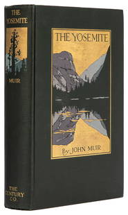
Sold2023 MUIR, John (1838-1914). The Yosemite. New York: The Century...MUIR, John (1838-1914). The Yosemite. New York: The Century Co., 1912. 8vo. 32 full-page plates from photographs, 3 folding maps. Original pictorial dark green cloth, top edge gilt (small spot of ghosSee Sold Price
BonhamsBRADFORD (THOMAS G.) A Comprehensive Atlas, Geographical, Historical & Commercial, 1835; and atl...£500
BonhamsMEYRICK (SAMUEL RUSH) AND CHARLES HAMILTON SMITH The Costume of the Original Inhabitants of the ...£60(3 bids)
BonhamsCRUIKSHANK (GEORGE) The Humorist: A Collection of Entertaining Tales, Anecdotes, Repartees..., 4...£190(8 bids)
Jul 06Rafael Osona AuctionsVintage Tilghman Packing Co. "Historical Map of the Maryland Eastern Shore", circa 1957$100
Jun 29JM Hobby Supply and Railroad Artifact AuctionsFlorence & Cripple Creek RR Public Timetable-September 1894$400
4 days LeftJeffrey S. Evans & AssociatesGII-64 "LIBERTY" EAGLE - WILLINGTON GLASS CO. PICTORIAL / HISTORICAL FLASK$180(3 bids)
5 days LeftJeffrey S. Evans & AssociatesMECKLENBURG CO. / UNION CO., NORTH CAROLINA PICTORIAL NEEDLEWORK SAMPLER$1,000
Jun 30Heartland Artifact Auctions Inc5 1/4" Hemphill, Bennett COA, **RESTORED ON ONE EAR***, found in Fulton Co., Illinois, Ex Carl & Roy$10
5 days LeftJeffrey S. Evans & AssociatesMIDDLESEX / NORFOLK CO., MASSACHUSETTS NEEDLEWORK SAMPLER$300(3 bids)
BonhamsHARLEQUINADE - MANUSCRIPT FLAP-BOOK A seventeenth century manuscript pictorial flap-book 'Painte...£2,800(3 bids)
BonhamsMITCHELL (SAMUEL AUGUSTUS) A New Universal Atlas Containing Maps of the Various Empires, Kingdom...£1,300
BonhamsSPEED (JOHN) AND WILLEM BLAEU Pictorial title-pages to Speed's 'Theatre of the Empire of Great B...£30(3 bids)
Featured4 days LeftJasper52Map of the Railroad System of the Central Railroad and Banking Co. Of Georgia$45(1 bid)


![Carroll, Lewis [Charles Lutwidge Dodgson] (1 of 1)](https://p1.liveauctioneers.com/94/330664/178342370_1_x.jpg?height=282&quality=70&version=1716466933)


