Sold2018Cram Map of TexasCRAM, George F (1842-1928). Railroad and county map of Texas. Lithograph with handcolor, with original black slipcase on the verso. Chicago, 1876. 17 3/4 x 24 inches sheet, 28 x 33 inches framedSee Sold Price
Sold2022Scarce Texas map (eastern part) from Asher & Adams,County map of Eastern Texas extends from Louisiana west to beyond San Antonio and features the railroad system of that time. Features numerous railroads still in their infancy, along with proposed futSee Sold Price
Sold2020Rand McNally & Co., County and Railroad Pocket MapRand McNally & Company, Indexed County and Railroad Pocket Map and Shipper's Guide of Texas, Chicago 1904 image size: 24 x 16", frame: 28 x 17.5" Fine separately published map of Texas, colored by couSee Sold Price
Sold2022Asher & Adams' unique RR map of Texas, 1871County map of East Texas depicted in the unique Asher & Adams’ style, without roads to highlight the presence of railroads. Extends from Louisiana west to beyond San Antonio and features the raSee Sold Price
Sold2017Colton: Antique Map of Texas, 18641860 Colton’s Texas - uncommon. From an 1864 school atlas. This map is not seen very often. Delineates all counties to 1860. Shows topography, forts, railroads, battle fields, rivers, etc. �See Sold Price
Sold20221885 Two-page Railroad map of TexasCram’s 1885 double-page railroad map of Texas has exceptional printed color. Every railroad line in the state is highlighted in a heavier black line than such things as county borders, rivers anSee Sold Price
Sold20201862 Colton Map of the United States -- Colton's NewTitle/Content of Map: 1862 Colton Map of the United States -- Colton's New Railroad & County Map of the United States the Canadas &c. Cartographer: J Colton Year/Place: 1862, New York Size: 33.1 X 39See Sold Price
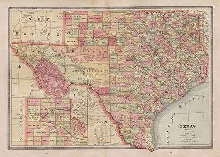
Sold2017Mitchell: Antique County Map of Texas, 1873Excellent 1873 County Map of Texas by S. Augustus Mitchell. Impressive two-page County Map of the State of Texas. Map image much larger than earlier Mitchell maps. Designed and engraved by W. H. GamblSee Sold Price
Sold2021Colton Railroad and County Map United States 1878Colton, after G. W., Colton's Railroad and County Map of the United States, The Canadas, &c, 1878, antique map on paper, folded as originally issued, 33 x 42 inches, in a wood frame 36.5 x 47.5 inchesSee Sold Price
Sold2018County Map of Texas.Reserve Reduced! Title: County Map of Texas. Publication Date: 1861 Cartographer: MITCHELL, SAMUEL AUGUSTUS (JR.) Publisher: S. Augustus Mitchell, Jr. Size: 10.75 X 13.25 Map 29 from Mitchell's New GeSee Sold Price
Sold2019Rand McNally & Co.'s New Railroad and County Map of theTitle/Content of Map: Rand McNally & Co.'s New Railroad and County Map of the United States And Dominion of Canada Date: 1882 Cartographer: RAND, MCNALLY & CO. Publisher: RAND, MCNALLY & CO. Size: 26.See Sold Price
Sold2018County Map of Texas.Title/Content of Map: County Map of Texas. Date Printed: 1870 Cartographer: MITCHELL, SAMUEL AUGUSTUS (JR.) Material/Medium: S. Augustus Mitchell, Jr. Size: 9.25X12 Inset of Galveston Bay and VicinitySee Sold Price
Sold2023Railroad and County Map of Montana.Publication Date: 1887 Title: Railroad and County Map of Montana. Cartographer: CRAM, GEORGE F. Publisher: A.A. Grant Height: 21.1 Width: 22.1 Detailed state map with railroads marked. Some topographySee Sold Price
Sold2017Mitchell: County Map of Texas, 1862County Map of Texas, S. Augustus Mitchell, 1862. 10.75 x 13.375 inches. Steel engraved map, with hand colored wash and outlines. Inset map of Galveston Bay, and Vicinity. Colored by county and territoSee Sold Price
Sold2018County Map of Texas, S. A. Mitchell, 1860Reserve Reduced! Authentic handcolored map of Texas with 1860 date but from Mitchell’s New General Atlas published 1864 by S. Augustus Mitchell. Detailed early map of Texas, immediately prior to theSee Sold Price
Sold2020Railroad and County Map of New Mexico.Title/Content of Map: Railroad and County Map of New Mexico. Date: 1888 Cartographer: CRAM, GEORGE F. Publisher: GEO. F. CRAM Size: 22.25Height - 16.25Width Detailed state map with railroads named butSee Sold Price
Sold2017Mitchell: Antique County Map of Texas, 1870Map: County Map of Texas Cartographer: S. A. Mitchell Place & Date: Philadelphia / 1870 Size: 13 1/4" x 10 3/4" Condition: full color; light overall age toning The beautifully detailed and colored couSee Sold Price
Sold2018Railroad and County Map of Florida.Title/Content of Map: Railroad and County Map of Florida. Date: 1887 Cartographer: CRAM, GEORGE F. Size: 21.8X15.6 From the Grant's Standard American atlas, cover date 1887. Shows railroads finished aSee Sold Price
Sold2020Railroad and County Map of OregonPublication Date: 1887 Title: Railroad and County Map of Oregon Cartographer: CRAM, GEORGE F. Publisher: A.A. Grant Height: 16.3 Width: 22 Detailed state map with railroads marked. Some topography. ShSee Sold Price
Sold2023Railroad and County Map of Dakota.Publication Date: 1887 Title: Railroad and County Map of Dakota. Cartographer: CRAM, GEORGE F. Publisher: A.A. Grant From the Grant's Standard American atlas, cover date 1887. Both finished and unfiniSee Sold Price
Sold2020Railroad and County Map of Nebraska.Title/Content of Map: Railroad and County Map of Nebraska. Publication Date: 1887 Cartographer: CRAM, GEORGE F. Publisher: A.A. Grant Description: From the Grant's Standard American atlas, cover dateSee Sold Price
Sold2020New Railroad and County Map of Georgia.Publication Date: 1889 Title: New Railroad and County Map of Georgia. Cartographer: CRAM, GEORGE F. Publisher: GEO. F. CRAM Height: 22.25 Width: 16.25 Detailed state map with railroad routes in colorsSee Sold Price
Sold2022Railroad and County Map of Maine.Publication Date: 1889 Title: Railroad and County Map of Maine. Cartographer: CRAM, GEORGE F. Publisher: GEO. F. CRAM Height: 22 Width: 15.8 Detailed state map with railroads in colors. Ornamental titSee Sold Price
Sold2024NEW RAILROAD AND COUNTY MAP OF MISSOURINEW RAILROAD AND COUNTY MAP OF MISSOURIChicago, circa 1878, From Cram's Illustrated Family Atlas of the World, published by George F. Cram, machine colored.10 x 12 in. (25.4 x 30.5 cm.), Frame: 16 x 1See Sold Price
5 days LeftSimpson Galleries, LLC.A TEXAS LAND GRANT FOR I&GN RAILROAD IN POLK COUNTY, SIGNED BY ORAN ROBERTS, 17TH GOVERNOR OF TEXAS,$100(1 bid)
Jun 12Dan Morphy AuctionsLOT OF 2 MAPS: LANDS IN THE COUNTIES OF RUNNELS & TOM GREEN RUNNELS COUNTY TEXAS MAPS.$200
5 days LeftSimpson Galleries, LLC.JULIUS BIEN (1826-1909) AN AMERICAN CIVIL WAR RECONNAISSANCE MAP, "Map of Texas and Part of New$100
22 hrs LeftJasper521854-5 Parke Profile Maps of California, Arizona and New Mexico -- Profiles from San Francisco Bay$55
Jun 13Swann Auction Galleries(NEW YORK -- ADIRONDACK MOUNTAINS.) Seneca Ray Stoddard. Map of the Adirondack Wilderness.$375
Jun 14DuMouchellesWilliam H. Gamble (American, B. 1863) Hand Colored Engraving, Ca. 1863, "County Map of Michigan And$50(1 bid)