Sold2023Antique Map County of Cumberland EnglandAntique Framed and Hand Colored Map of the County of Cumberland, England by Richard Blome (London Engraver 1600-1705) . 16 inches x 13 inchesSee Sold Price
Sold2023Antique Map County of Northumberland EnglandAntique Framed and Hand Colored Map of the County of Northumberland, England by Richard Blome (London Engraver 1600-1705) . 16 inches x 13 inchesSee Sold Price
Sold20231856 Richard Clark Map of Fairfield CountyDescription: This lot includes an original 1856 map of Fairfield Country by Richard Clark. The lamp is still on it's original wood poles and has been rolled up for decades. Condition: The map is in faSee Sold Price
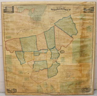
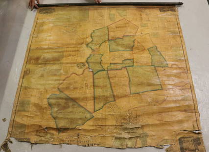
Sold2022MAP OF NORTHAMPTON COUNTY, PA 1860LINEN BACKED MAP MOUNTED ON BACKBOARD UNDER PLEXIGLASS (NO FRAMEWORK). SMITH,GALLUP & CO. PUBLISHERS, PHILADELPHIA, 1860. MEASURES 60" X 58". Terms & Conditions: Pick-up for this Auction will be WedneSee Sold Price
Sold2022MAP OF NORTHAMPTON COUNTY, PA 1860LINEN BACKED MAP. SMITH, GALLUP & CO. PUBLISHERS, PHILADELPHIA, 1860. MEASURES 56" X 57" Terms & Conditions: Pick-up for this Auction will be Wednesday August 3rd and Thursday August 4th from 9:00am tSee Sold Price
Sold2023RARE - 1673 1st ISSUE Antique Map 'A MAPP OF SURREY WITH ITS HUNDREDS' by Richard Blome.RARE - 1673 1st ISSUE Antique Map 'A MAPP OF SURREY WITH ITS HUNDREDS' by Richard Blome. A fine 1st Issue example of this map by Richard Blome. Published in 'BRITANNIA or a Geographical Description ofSee Sold Price
Sold2022c1700 Blome Engraved Map Travels Voyages ApostlesFinely engraved "Mapp of the Travels and Voyages of the Apostles in their mission and in particular of St. Paul", attributed to Richard Blome (1641-1705), London. Folding map in fine condition, measurSee Sold Price
Sold20181833 Census Map of the Counties of Leicester,Reserve Reduced! Title/Content of Map:1833 Census Map of the Counties of Leicester, Northampton, Ruthland, Warwick and Worcester -- Counties of Leicester, Northampton, Ruthland, Warwick and WorcesterSee Sold Price
Sold2018World Map - Hand-Colored Engraving - England, 17thA Mapp or Generall Carte of the World Designed in two Plaine Hemisphers, by Monsieur Sanson Geographr to the French King and Rendered into English and Illustrated with Figures by Richard Blome By theSee Sold Price
Sold2022(BRITISH ISLES.) Richard Blome. A Generale Mapp of the Isles of Great Brittaine.(BRITISH ISLES.) Richard Blome. A Generale Mapp of the Isles of Great Brittaine. Engraved folding map of Great Britain and Ireland. 15¾x20½ inches sheet size, narrow margins; original folds,See Sold Price
Sold2017Blome: Map of Turkish Empire in Asia & Europe, 1682Blome, A Map of the Estates of the Turkish Empire in Asia and Europe, 1682. An original copperplate engraving published by Richard Blome in 1682, with original outline color. This is an especially uniSee Sold Price
Sold20221687 Blome Engraved Maps Canaan Holy Land JerusalemTitle: 1687 Blome Engraved Maps Canaan Holy Land Jerusalem Description: Finely engraved "Canaan Commonly called the Holy Land of Promise …..", engraved by Richard Palmer for Richard Blome (1641-See Sold Price
Sold2022Scotland.- Blome (Richard) A Mapp of the Kingdome of Scotland, engraved map with hand-colouring,Scotland.- Blome (Richard) A Mapp of the Kingdome of Scotland, engraving, an excellent impression with full hand-colouring, on laid paper with watermark of bunch of grapes, sheet 390 x 407 mm (15 1/2See Sold Price
Sold202218th C. WAYNE COUNTY PA DRAWN PROPERTY DRAFT MAPLAND SURVEYED DECEMBER OF 1784, SIGNED BY GEORGE PALMER OF NORTHAMPTON COUNTY, MOUNTED ON CANVASSee Sold Price
Sold2021R. Blome on His Majesty's Territories in America, 1687R. Blome on His Majesty's Territories in America, 1687 1st Edition with 7 Folding Morden Maps Inc. Carolina, Virginia, New York & Bermuda BLOME, Richard. The Present State Of His Majesties Isles aSee Sold Price
Sold2022KENT – LYDD – MANUSCRIPT ESTATE MAP 'A Map of a Farm lying in the Parish of Lydd in ...KENT – MANUSCRIPT ESTATE PLAN 'A Map of a Farm lying in the Parish of Lydd in the County of Kent Belonging to the Reverd. Mr Richard Monins 1774.', manuscript map by Henry Maxted & Isaac Terry,See Sold Price
Sold2022Map of the Town of Cornwall, Connecticut, Circa 1854Map of the Town of Cornwall, Connecticutcirca 1854marked "Map of the Town of Cornwall, Litchfield County, Connecticut, Surveyed & Drawn by L. Fagan, Published by Richard Clark, 42, Moyamensing RoSee Sold Price
Sold2018Guadalcanal DiaryGuadalcanal Diary Map End papers. Penquin Special. Photo covers. Author: Richard Tregaskis Dated: 1944 Pages 217 Publisher: InfantrySee Sold Price
Sold2016[Map] Seale, Richard. Map of North AmericaSeale, Richard William. A Map of North America with the European Settlements & Whatever Else is Remarkable in ye West Indies.... [London, c.1745.] Sheet measuring 505mm x 408mm. Rather toned, 2" closeSee Sold Price
Sold2022Richard Blome (English, 1635-1705), Five Hunting Scenes, consisting of: "Takeing Say of Ye Stagg,"Richard Blome (English, 1635-1705), Five Hunting Scenes, consisting of: "Takeing Say of Ye Stagg," "Vnharbouring y Stagg," "Hunting Ye Wild Bore," "Showing Ye Buck Head to Ye Hound and Rewarding Them,See Sold Price
Sold2019Group of 6 Richard Blome EngravingsRichard Blome (1635-1705). Group of six engravings, titled "Death of the Fox," "Partridg [sic] Hawking," "Ceres," "Pomona," "Death of ye Hare w[i]th Fleet Hound," and "Brook Hawking." Each with a dediSee Sold Price
Sold202118th c. Richard Blome Engraving Depicting PartridgeThis quality matted and framed 18th century hand-colored English Engraving by Richard Blome whimsically depicts a partridge hunt and is in dedication to Sussex Baronet Sir John Shelley of Michelgrove.See Sold Price
Sold2019Richard Blome (British, 1635-1705)Richard Blome (British, 1635-1705) , 5 hand-colored engravings, 1686, from The Gentleman's Recreation, sights 13 1/4 in. x 8 in., framed alike. (5 pcs.) . Provenance: The Sturm Collection Condition ReSee Sold Price
Sold202318th C. Richard Blome Copper Plate Engravings Hunting**Originally Listed At $250** Richard Blome (British, 1635-1705). Hand-colored copper plate engravings, London: ca. 1686 to 1710. A trio of original 18th century hand-colored copper plate engravings fSee Sold Price
6 days LeftJasper521764 ACCURATE MAP OF THE COUNTY OF NORTHAMPTON antique 17.5 x 21.5" 18th CENTURY$75
Jun 14DuMouchellesWilliam H. Gamble (American, B. 1863) Hand Colored Engraving, Ca. 1863, "County Map of Michigan And$50(1 bid)
6 days LeftJasper521872 Mitchell Map of Massachussetts, Connecticut and Rhode Island -- County Map of Massachussetts,$40
6 days LeftJasper521872 Mitchell Map of Louisiana, Arkansas and Mississippi -- County Map of the States of Arkansas,$40
6 days LeftJasper521878 Mitchell Map of Georgia and Alabama -- County Map of the States of Georgia and Alabama$50


![[Map] Seale, Richard. Map of North America: Seale, Richard William. A Map of North America with the European Settlements & Whatever Else is Remarkable in ye West Indies.... [London, c.1745.] Sheet measuring 505mm x 408mm. Rather toned, 2" close](https://p1.liveauctioneers.com/3532/91776/46880446_1_x.jpg?height=310&quality=70&version=1469669287)

![Group of 6 Richard Blome Engravings: Richard Blome (1635-1705). Group of six engravings, titled "Death of the Fox," "Partridg [sic] Hawking," "Ceres," "Pomona," "Death of ye Hare w[i]th Fleet Hound," and "Brook Hawking." Each with a dedi](https://p1.liveauctioneers.com/5985/144677/73148326_1_x.jpg?height=310&quality=70&version=1561237433)


