Sold2022ORTELIUS, ABRAHAM; and PHILILLPE GALLE. Set of 5 miniature maps of the world and continents.ORTELIUS, ABRAHAM; and PHILILLPE GALLE. Set of 5 miniature maps of the world and continents. Engravings with original hand-color. 4x5½ inches each sheet size, Latin text on verso; light finger soSee Sold Price
Sold20211627 Carte de l'Amerique Corrigee, et Augmentee, dessusBy: Bertius/TavernierDate: 1627 (circa)Dimensions: 20 x 15.25 inches (50.75 x 38.5 cm)According to Burden, "This rare map is one of a set of the four known continents that Melchior Tavernier had engraSee Sold Price
Sold2021Hall, Sidney C1850 Set of 5 Continent MapsEurope, Aisa, Africa, North America, and South America. Steel Engraved Maps Published C1850, London for "A Grammar of General Geography..." by the Rev. J. Goldsmith & Edward Hughes. Folds as issed. MaSee Sold Price
Sold2017Seutter World Map, 1730Title: 1730 Seutter World Map Cartographer: M. Seutter Published: 1730 c Augsburg Measurements: 19.5 x 22.7 in. Diversi Globi Terr-Aquei Statione Variante et Visu Intercedente per Coluros Tropicorum pSee Sold Price
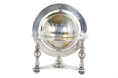
Sold2023Bulgari Sterling Silver & Vermeil Table Globe 805gA Bulgari Italian sterling silver table globe sculpture. Classical style design with spinning world map globe set within a round tri legged ring stand. Map continents finished in gold vermeil, and surSee Sold Price
Sold2018Seutter: Antique Map of the World, 1740Title/Content of Map: World by Seutter Date Printed: c1740 Cartographer: Matthaus Seutter Material/Medium: Paper Size: 24" x 19 1/2" Original hand colored Copperplate engraved. Published in Augsburg iSee Sold Price
Sold2023Signed Richard Schultz Knoll Promotional Mini Bocce Ball Set. 2). Walnut Promotional Clock. 3). MidSigned Richard Schultz Knoll Promotional Mini Bocce Ball Set. 2). Walnut Promotional Clock. 3). Mid Century World Map, Airplane Hand Chrome Alarm Clock Dimensions: Height: 5 inches, Width: 4.5 inches,See Sold Price
Sold20191891 Cram Double Hemisphere World Map -- EasternTitle/Content of Map: 1891 Cram Double Hemisphere World Map -- Eastern Hemisphere; Western Hemisphere Cartographer: G CramDate: 1891, Chicago Size: 13 x 10.5 in. A very nice double page map set of theSee Sold Price
Sold20231730 MAP UKRAINE CRIMEA RUSSIA BLACK & AZOV SEA antique NOVA MAPPA GEOGRAPHICANOVA MAPPA GEOGRAPHICA MARIS ASSOVIENSIS vel de ZABACHE et PALUDIS MAEOTIDIS accuratè aeri incisa et in lucem edita per Matthaeum Seutter chalcograph. Augsburg; 1730 Overall size 21.5 by 25.5" ImSee Sold Price
Sold2020Set 3 Framed Maps. The World, Canada, and MediterraneanSet 3 Framed Maps. The World, Canada, and Mediterranean. -- Dimensions: H: 13.5 inches: W: 18 inches ---See Sold Price
Sold20241944 Lowell Thomas' War Map of the World -- Lowell Thomas' War Map of the WorldTitle: 1944 Lowell Thomas' War Map of the World -- Lowell Thomas' War Map of the World Cartographer: Rand McNally Year / Place: 1944 c. Map Dimension (in.): 25.5 X 18.8 in. This is a fascinating set oSee Sold Price
Sold2023World Map by Ceramiche Zaccacnini, set as Coffee TableLot 133 World Map by Ceramiche Zaccacnini, set as Coffee Table map of the world, centered on the Atlantic Ocean and surrounding continents 19 x 36 x 20 1/2 inches Provenance: Property from the CollecSee Sold Price
Sold2017Mallet: Antique Map of the World/France, 1683Title/Content of Map: 'Planisphere du Monde; France' FRANCE/WORLD. odd-shaped Australia close to southern continent. Date Printed: 1683 Image Size: Approx Overall page size 13 x 21cm approximately (5See Sold Price
Sold2017Mallet: Antique Map of the World; France, 1683Map Title: 'Planisphere du Monde; France' FRANCE/WORLD. odd-shaped Australia close to southern continent. Date Printed: 1683 Image Size: Approx Overall page size 13 x 21cm approximately (5 x 8 inches)See Sold Price
Sold2021Bartholomew, John 1889 Lot of 5 Continents MapsCommercial Continent Maps of Asia, Africa, Europe, North & South America. Lithograph Maps Published 1889, Cambridge for "Atlas of Commercial Geography" by John George Bartholomew. Paper Size: 12 x 10See Sold Price
Sold2018AfricaTitle: Africa Publication Date: 1763 Cartographer: JEFFERYS, T. Publisher: S. AND E. BALLARD, etc. Size: 7X9.5 Continent map from Salmon's The Modern Gazetteer. 5th edition. Few stains. Please note thSee Sold Price
Sold20211873 World MapAuthor: Bartholomew Title: 1873 World Map Medium: Ink on Paper Dimensions: 18"X13.5" World map dated 1873. Drawn on Sir J. Herschel's Projection. Part of Zell's Descriptive Hand Atlas of the World. PuSee Sold Price
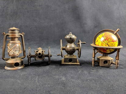
Sold2019Vintage Diecast Miniature Pencil Sharpener Lot of 4Lot of 4 diecast metal vintage pencil sharpeners. They are believed to be from the 1970's. Good used condition. Untested. Lantern (3"x2"x1") Civil War Cannon (4.5"x2"x1.5") World Map Globe(3.75"x3"See Sold Price
Sold20231941 Year Set - 5 Coins - World War II w/ Historic Events Listed1941 Year Set - 5 Coins - World War II w/ Historic Events ListedSee Sold Price
Sold2023Set 5 Britannica World Data Annual BooksBritannica World Data Annuals, dates are 1986-1990. Encyclopaedia Britannica, Inc. Chicago. Set 5 books measures app 11.5 x 9 x 1.5 in. Gilt page edges. Black leatherette covers. Covers everything froSee Sold Price
Sold2021Bartholomew, John 1889 Lot of 5 World, Europe MapsIncl Natural Productions, Chart of the World of showing Heights and Depths, Sketch Chart of the North Atlantic, Railway Map of Central Europe, and Railway Map of British Isles. Lithograph Maps PublishSee Sold Price
Sold2024Carte De La Californie Suivant (early Group of 5 California maps) 1772 [171215]A spectacular set of 5 maps showing California history from 1604 to 1767. Measures 15x12[x=#8221/]. 1) Earliest map (upper right) is based upon a manuscript map by Mathieu Neron Pecci drawn in FlorencSee Sold Price
Sold2024Set of 5 Rare Original Olsson Brothers World's Fair 1939 "Dala" Horse SculpturesSet of 5 World's Fair 1939 Hand-Made Swedish Dalah?st "Dala" Horse Figurines - Hand carved and painted in Nusn?s, Mora Municipality, Dalarna County, Sweden by the Olsson. Marked "Jannes & Nils OlsSee Sold Price
Sold2018Set of 5 Trinket Dishes by Christian LacroixSet of 5 continent trinket dishes, by Christian Lacroix, Asia, Africa, America, Europe, and OceaniaSee Sold Price
Jun 18DOYLE Auctioneers & AppraisersA block puzzle with maps of Europe, England, Ireland, Scotland, America and the World$100
6 days LeftJasper521881 Vuillemin World Map with French Colonies Shown -- Planisphere: Indiquant les Colonies Francises$30
7 hrs LeftChampagne AuctionsWORLD 1992-1996 A 15 Coin 100th. Anniversary of the Olympics ProofCA$5,500
3 days LeftTrillium Antique Prints & Rare BooksDonovan's The Natural History of British Shells - 5 Volumes in 2 Books with 180 Engravings$400
BonhamsROGERS (WOODES) A Cruising Voyage Round the World: First to the South-Sea, thence to the East-In...£400
6 days LeftJasper521660 HISTORY of the WORLD by WALTER RALEIGH antique ILLUSTRATED w/ MAPS English$700
Jun 05Jasper52Partie Occidentale de l'Ancien Continent… W Africa Macaronesia. BONNE 1780 map$30
Jun 06World of Antiques, Inc.JD Schleissner & Sohne Hanau Germany Sterling Silver liqueur set for 8$1,200


![Carte De La Californie Suivant (early Group of 5 California maps) 1772 [171215]: A spectacular set of 5 maps showing California history from 1604 to 1767. Measures 15x12[x=#8221/]. 1) Earliest map (upper right) is based upon a manuscript map by Mathieu Neron Pecci drawn in Florenc](https://p1.liveauctioneers.com/2699/324080/174413209_1_x.jpg?height=310&quality=70&version=1711485545)


