Sold2015Two Hand-Colored Old World MapsTwo Hand-Colored Old World Maps of England/Wales and the Americas, consisting of "Accuratissima Angliae Regni et Walliae Principatus...", engraved by Cornelis Danckerts, ca. 1690-1700, plate 20-1/2" xSee Sold Price
Sold2022MAP, Middle East, WitMiddle East. Frederick de Wit, Nova Persiae Armeniae Natoliae et Arabiae, 1680 (circa). Hand Color. This splendid map of the Middle East covers the region from Turkey and Egypt to Afghanistan with theSee Sold Price
Sold2022MAP, Britain, JanssonJansson's Splendid Heptarchy Map in Full Contemporary Color. Britain. Jan Jansson, Britannia Prout Divisa Suit Temporibus Anglo-Saxonum, Praesertim Durante Illorum Heptarchia, from Atlas Novus, 1646 (See Sold Price
Sold2023Russell & Barclay 1838 Hand Col Map. World Hemispheres"New World or Western Hemisphere" "Old World or Eastern Hemisphere" Hand Colored Steel Engraved Map Published 1823-40, by Fisher & Son, "A Complete Atlas of the World" by John Russell et al. A Very RaSee Sold Price
Sold2023Assorted Maps on Europe & the Sub ContinentAssorted maps on Europe, Scandinavia, and the Sub Continent, including Celestial and World Maps, some old and hand colored, some modern and picture reproductions. Provenance: Phyllis Lucas Gallery, NYSee Sold Price
Sold2018Hand Colored Map of the World, Willem BlaeuWillem Blaeu, (Dutch, 1571-1638) "Nova Totius Terrarum Orbis Geograhica ac Hydrographica" originally published 1606 Nice old color example of Blaeu's classic world map Approx. 19.5" x 25.5" (unframed)See Sold Price
Sold2023Holy Bible w Cross Zipper Leather BookThe Holy Bible Concordance with the Old & New Testaments, the authorized King James Version by World Publishing Co, NY/ Cleveland. Printed in the USA. Has colored illustrations and colored maps. BookSee Sold Price
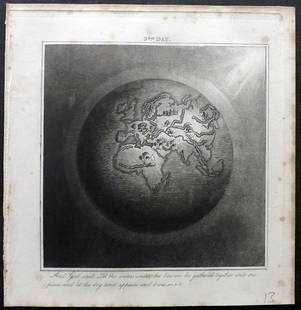
Sold2023Calmet, Augustin 1732 Large Map. Old World according to Noah's Sons"A Geographical Map of the Old World according to the division of it among Noah's Sons" Folio Copper Plate Published 1732, London for "An Historical, Critical, Geographical, Chronological and EtymologSee Sold Price
Sold20201855 Smith’s ATLAS Geography 36 BEAUTIFUL Colored MAPS1855 Smith’s ATLAS Geography 36 BEAUTIFUL Colored MAPS World ‘Smith’s Atlas of Modern and Ancient Geography’ is a collection of maps focusing on the United States, but includes maps of the worSee Sold Price
Sold2024Antique Colored Engraving Map - Old Map of Stockholm - Swedish Empire - HomannImpressive and historically significant colored copper engraving depecting old map of Stockholm created by Johann Baptist Homann, published between 1720-1721. This masterful work of cartography providSee Sold Price
Sold2021(18C.) Antique Hand Colored Map of Old Vienna 1791Antique hand colored etched old map from the famous works published in Vienna in 1791. In three parts, compiled with drawn lines representing extant postal routes at the time. Housed in wooden frame.See Sold Price
Sold2022Cellarius & Patrick 1816 Map. Hemisphere, Old WorldCopper Engraved Map Published 1816, London for "Geographia Antiqua" by Samuel Patrick. Maps based on those by Andreas Cellarius. Folds as issued. Paper Size: 10 x 8 inch (26 x 20cm) Good ConditionSee Sold Price
Sold2018ANTIQUE HAND COLORED WORLD MAP WITH SCENIC CORNERS.ANTIQUE HAND COLORED WORLD MAP WITH SCENIC CORNERS ON EARLY LAID PAPER. IMAGE 22 3/4 X 19 1/4See Sold Price
Sold2020Jan Jansson Hand Colored Old Map of South AmericaJan Jansson (Johannes Janssonius; Dutch, 1588-1664). Framed antique etching print of South America. Titled AMERICAE PARS MERIDIONALIS. Hand colored. Unknown printing date in two sheets joined in the mSee Sold Price
Sold2017Hand Colored World Map, FramedHand Colored World Map, Framed. Overall Dimensions: 30 x 33 in. This item is framed behind glass. Late 20th Century.See Sold Price
Sold2019Rhind, William 1844 Rare Map of the Old World. EarthAquatint Map Published 1844, London "The Creation: Illustrated By Six Engravings On Steel" by William Graeme Rhind. Rare. Paper Size: 6.5 x 6 inch (16.5 x 16cm) Very minor margin toning, slightly affeSee Sold Price
Sold2020Framed Hand Colored Map of The World 19th CenturyFramed Hand Colored Map of The World 19th Century. Original Map of World Hemispheres with supposed population and religious division. Certificate of Authenticity on back.Condition: Very Good, slight wSee Sold Price
Sold2022Antique World Map - Colored Etching Pre 1775World Map. Due to laid paper technique, we believe it may be pre-1775. This map is based on the 1594 world map by Peter Plancius, but what draws the eye are the lively figures depicted in the corner sSee Sold Price
Sold2022Framed Needlepoint Old World Map Antique needlepoint of the world featuring the oceans and nauticalAntique needlepoint of the world featuring the oceans and nautical references.Framed 20.5" x 20"STERLING ASSOCIATES STRIVES TO PROVIDE ACCURATE, OBJECTIVE, & FAIR INFORMATION ON ALL LOTS. WE WILL BE HSee Sold Price
Sold20221814 map of the Old World, WilkinsonExcellent map of the Old World titled “Terra Veteribus Nota” (Land of the Old) from An Atlas Of Ten Select Maps Of Ancient Geography Both Sacred And Profane; With A Chronological Table OfSee Sold Price
Sold2023John Speed (1552 – 1629) A new and Accvrat Map of the world 1651Description: John Speed (1552 – 1629) A new and Accvrat Map of the world 1651 Measurement approximate:Material: PaperSee Sold Price
Sold2024Paint Decorated Old World Map BoxPaint Decorated Old World Map Box. 23 3/4" W 12" D 12" H ALL DESCRIPTIONS AND ANY CONDITION STATEMENT GIVEN BY LANGSTON AUCTION GALLERY ARE STRICTLY OPINIONS AND LANGSTON'S SHALL HAVE NO RESPONSIBILITSee Sold Price
Sold2019Embossed Leather Decanter w Old World Map DesignEmbossed Leather Decanter w Old World Map Design. Measures 10 inches in height.See Sold Price
1 day LeftThe Bidder AuctionsThe map of the railways in the Land of Israel - published by the Surveying Department of the British$30
3 days LeftRoyal Treasures Warehouse LLC1530s Old Map of the World as seen from the North & South Poles$50
Jun 09Worthington Galleries18th c. Map OBSERVATIONS SUR LES POINTS CARDINAUX. LIGNES, ET CIRCLES DE LA SPHÈ$10
Jun 09Worthington GalleriesAntique Hand-colored Hemisphere Map Mappemonde Revue par E. Cortambert 1864$25
Jun 18DOYLE Auctioneers & AppraisersA block puzzle with maps of Europe, England, Ireland, Scotland, America and the World$100
3 days LeftNorthgate Gallery, Inc.Vintage Baker Furniture George II Style Wing Back Arm Chairs, Pair$200
Jun 07Freeman's | Hindman[MAP]. TODESCHI, Pietro. [Nova et Acurata Totius Americae Tabula auct. G.I. Blaeu] America quarta$5,000
3 days LeftTrillium Antique Prints & Rare BooksKohler & Weigel - Map of the World with North and South Pole views$75(1 bid)
Jun 07Freeman's | HindmanMURCHISON, Roderick Impey, Sir. The Silurian System. 1839. COMPLETE WITH VERY RARE HAND-COLORED$1,500


![[MAP]. TODESCHI, Pietro. [Nova et Acurata Totius Americae Tabula auct. G.I. Blaeu] America quarta (1 of 1)](https://p1.liveauctioneers.com/197/329395/177650542_1_x.jpg?height=282&quality=70&version=1715364962)


