Sold2022THREE FRAMED ENGRAVINGS.Two early 19th century German hand colored engravings of maps. 11.5"h. 10.25"w. Together with a 17th century Simon de Passe engraving on laid paper of Sir Walter Raleigh. 12.75"h. 9.75"w.See Sold Price
Sold202117th C. French Engraving Map of N. Africa MoroccoFrench hand-colored engraving of North Africa, including Morrocco, parts of Algeria, Strait of Gibraltar. Dated 1655. Measures 16"H x 21"W visual image , 23.75"H x 27.75"W framed. Condition report: GoSee Sold Price
Sold2020Three 17th C French Legal ManuscriptsThree French legal manuscripts with one of three pages 1662m, one page documents 1696 and 1705 on Fine paper. Measures 7.5 x 11". Reserve: $50.00 Shipping: Domestic: Flat-rate of $5.00 to anywhere witSee Sold Price
Sold202417TH C. ANTIQUE MAP SIEGE OF LA ROCHELLE, FRANCE, FRAMED"Seige et Reddition de La Rochelle, Octobre 1628", handcolored engraving on wove paper, Claes Jansz. Visscher (II), (workshop of), Germany, 1627 - 1629. In gilt molded frame, matted under UV non-glareSee Sold Price
Sold2022THREE EUROPEAN ENGRAVED MAPS.Mid 17th century. Two hand colored maps of Corfu by Johann Baptiste Homann. Some toning, edge damage and one is stained. 21"h. 24.5"w. And uncolored French map of "Bois le Duc, Hertogenbosch", publishSee Sold Price
Sold2022Pair hand-colored antique maps, 17th c.Pair hand-colored antique maps, 17th c., Philipp Cluver (German, 1580-1622), "Viro Antiqua domo Generoso ac Nobili: Omni Virtute pollenti...", engraving of Ancient Italy on laid paper, as two sheets jSee Sold Price
Sold2024BLAEU 17TH C. MAP OF THE SARLAT REGION OF FRANCEHand-colored engraving with centerfold and text verso. Full description on dealers label. Dated to circa 1642. Matted. Dimensions: L 27" x W 22" Condition: Paper with light age toning. Offset from texSee Sold Price
Sold2024Three Engravings after Gabriel Bodenehr (1673-1765) c. 1667Continental, 17th century. An engraving after Gabriel Bodenehr (1673-1765) on laid paper. Fleur de lis watermark present. Loosely pasted at top corners to backing paper. Plate itself measures 9.5 x 7See Sold Price
Sold2022TWO EUROPEAN MAPS.Mid 17th century, hand colored engravings on laid paper. William Blaeu map of "Karstia, Carniola, Histria et Windorum Marchia". Text on back. Crease. 18.5"h. 22.75"w. And Nicolaum Visscher map of "BelSee Sold Price
Sold2024'Antiquae Statuae Togatae' Antique EngravingContinental, 17th century. A small engraving of three robed statues. Measures 7 x 6 inches on laid paper.See Sold Price
Sold2020TWO EUROPEAN MAPS BY WILLIAM BLAEU.Amsterdam, 2nd quarter 17th century, hand colored engravings on rag paper. "Brabantia Ducatus" and "Ducatus Holsatiae". Matching late frames, 22.5"h. 27"w. overall.See Sold Price
Sold2023Salvator Rosa (1615-1673) Small Trilogy Folio EngravingItaly, 17th century. Three original small etchings on laid paper by Italian artist, Salvator Rosa (1615-1673). Overall good condition; cut from a larger folio page. Entire page measures 8 x 14.5. incSee Sold Price
Sold2023AFTER NICOLAS SANSON (FRENCH, 1600-1667) MAP OF CALIFORNIA AS AN ISLANDAFTER NICOLAS SANSON (FRENCH, 1600-1667) MAP OF CALIFORNIA AS AN ISLAND, hand-colored engraving on laid paper, titled "AUDIENCE DE / GUADALAJARA / NOUVEAU MEXIQUE / CALIFORNIE, &c. / Par N. SSee Sold Price
Sold2023An Engraving of 'Martyrdom of St. Peter' by Louis de Boullogne (French, 1609–1674)France, 17th century. A copperplate engraving by Louis de Boullogne (French, 1609–1674) dating to 1649. Laid on paper for support.See Sold Price
Sold20241630 MAP OF TARTARY CHINA RUSSIA copper engraving ANTIQUEEarly 17th century map of Tartary, reduced from the larger edition of the map which appeared in the French Mercator-Jodocus Hondius Atlas Minor in the 1630s. Very fine and decorative engraving showingSee Sold Price
Sold20231630 MAP OF TARTARY CHINA RUSSIA copper engraving ANTIQUEEarly 17th century map of Tartary, reduced from the larger edition of the map which appeared in the French Mercator-Jodocus Hondius Atlas Minor in the 1630s. Very fine and decorative engraving showingSee Sold Price
Sold20172 L. Kilian Engraving & J. Callot Etching 17th c.Lot of 2 Lucas Kilian (German 1579-1637), "Ferdinand (de Medici) Drand Duke of Tuscany", Engraving, 16th c. & Jacques Callot (French 1592-1635) 3 Etchings on Laid Paper, "The Passion of Christ", 17thSee Sold Price
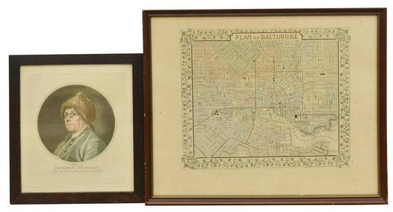
Sold2020(2) BEN FRANKLIN RUOTTE & BALTIMORE MAP ENGRAVINGS(lot of 2) Framed engravings on paper, including: (1) Benjamin Franklin (American, 1706-1790), after the original drawing by Charles Nicolas Cochin II (French, 1715-1790), engraved by C. Ruotte (LouisSee Sold Price
Sold2022John Ogilby, three road maps, including London to Norwich, hand coloured engravings, late 17thJohn Ogilby, three road maps, including London to Norwich, hand coloured engravings, late 17th century, 35 x 45cmSee Sold Price
Sold2017Two 17th Century Maps of England/Scotland andTwo 17th Century Maps of England/Scotland and Ireland/France. Two hand-colored engravings, with text in French, with genealogies of the kings Larger: 15" x 19" Frames: 22.75" x 26.75"See Sold Price
Sold2023Antique 17th C Map of Canary Islands Pierre DuvalAntique 17th C Map of Canary Islands Pierre Duval. Original proof engraved in 1653 by cartographer Pierre Duval (French, 1618 - 1683). Colored boundaries of the time. Engraving margins measure 13.5 inSee Sold Price
Sold2022Extraordinary Book of Engravings from Captain Cook's Voyages, c. 1784First Edition, c. 1784. 60 copperplate engravings drawn by John Webber (1751-1793) on chain-laid paper. Depicting images from the three voyages of Captain Cook. Contains a foldout map at the rear. PrSee Sold Price
Sold2019Group of Three 17th C French Manuscript DocumentsThree French manuscript documents latter 16th and early 17th century, one dated 1617. Approximately 8 x 11” each. Fine condition. Reserve: $20.00 Shipping: Domestic: Flat-rate of $5.00 to anywhere wSee Sold Price
Sold202217th C. French Engraving - Fortress DiagramAttributed to Vauban (French, 1633-1707). A 17th century French plan of Charleville, most likely by Vauban given the style, that features the Citadel, the River Meuse, and fortification demarcations.See Sold Price
Jun 15Riverfront Auctions'View of the Castel Sant'Angelo and Ponte Sant'Angelo in Rome' by Nicolas Perelle$5(1 bid)
6 days LeftJasper521687 19 volumes Bibliotheque Universelle et Historique antique ILLUSTRATED 17 c.$800
3 days LeftLink Auction GalleriesAfter Jusepe De Ribera, Naples, Italy 17th century, 17th c. Old Master Drawing of the Mourning of$150
13 hrs LeftForum AuctionsTibet.- Charm scroll with an apocryphal Buddhist text, [Tibet], [17th century].£400
20 hrs LeftNY Elizabeth ANTIQUE PARCHMENT BY BYZANTINE OTTOMAN TURKISH CONSTANTINOPLE, DATED 1632.$50
20 hrs LeftNY Elizabeth JESUIT C. LAPIDE, 1635, COMMENTARIA IN OMNES DIVI PAULI EPISTOLAS VELLUM FOLIO$50
20 hrs LeftNY Elizabeth 1657 TERENCE COMEDIES OLD VELLUM POETRY PUBLIUS TERENTIUS AFFIRMATIVAE SEXUALES$50
842 Lots AwayThousand Planet Auction HouseAn Antique Ming Dynasty Tibetan Chung Dzi Bead, c. 14th-17th Century$10
Jun 30Global Auctions CompanyJohann Matthias Kager (1575-1634) Engraving S. Hieronimus in the Wilderness$200


![Tibet.- Charm scroll with an apocryphal Buddhist text, [Tibet], [17th century]. (1 of 4)](https://p1.liveauctioneers.com/5458/329231/177514968_1_x.jpg?height=282&quality=70&version=1715269091)


